The Story
The Burr Trail is the kind of road that makes you pull over every quarter mile, not because anything is wrong with your car but because something extraordinary keeps appearing through the windshield. It runs roughly 66 miles from the tiny town of Boulder through some of the most dramatic canyon and slickrock scenery in Utah, crossing the Waterpocket Fold and ending at the Notom-Bullfrog Road near Capitol Reef National Park. The first 30 miles are paved. The last section, descending the Burr Trail Switchbacks through the Waterpocket Fold, is not. The entire route is one of the finest drives in the American West.
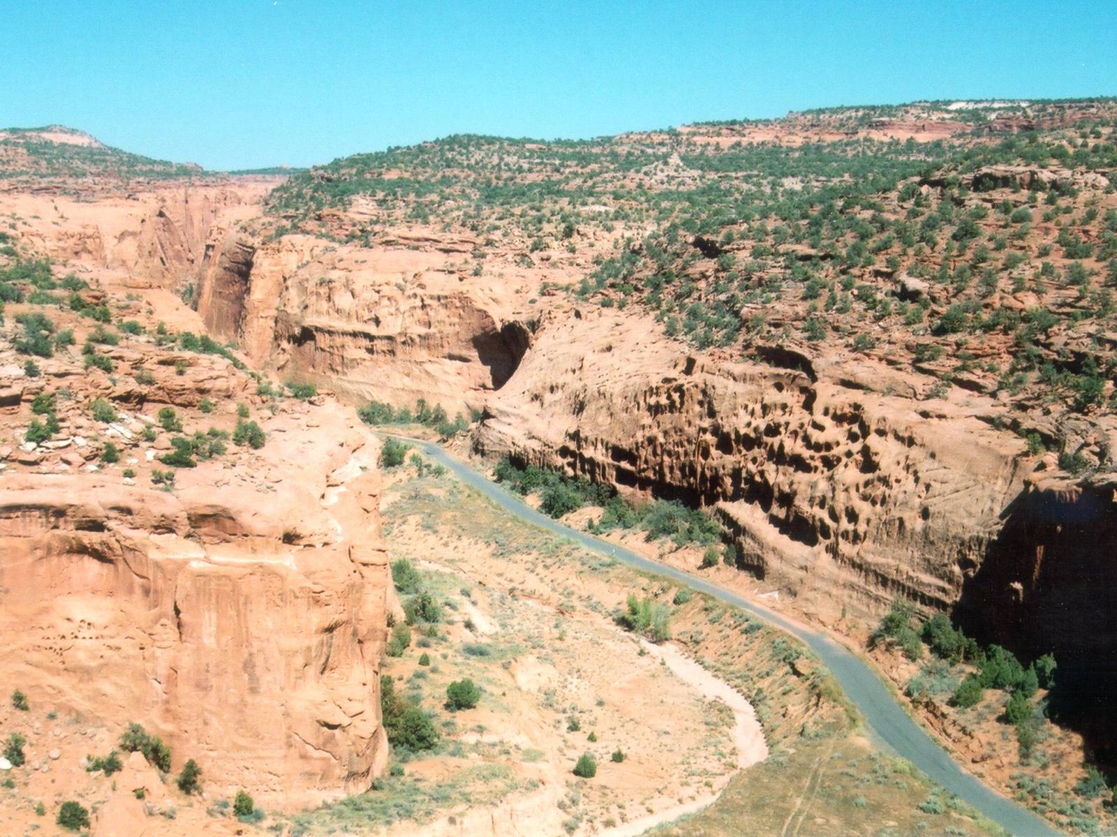
The road begins in Boulder, itself one of the most isolated towns in the lower 48 — it did not receive paved road access until 1971 and got its mail by mule train until 1940. Heading east from town, the pavement winds through Long Canyon, and this is where the Burr Trail announces its intentions. The canyon walls close in on both sides, rising hundreds of feet overhead in smooth, sweeping curves of Navajo Sandstone. The rock is cream and salmon colored, streaked with dark desert varnish, and the narrowest sections feel like driving through a roofless cathedral. The scale is immense but intimate — the walls are close enough to feel their presence but tall enough to make you feel small.
Long Canyon opens into a broader valley of slickrock and sparse desert vegetation before the road enters the Circle Cliffs, a horseshoe-shaped formation of eroded sandstone that wraps around the Lamp Stand and other isolated buttes. The colors here shift from the pale Navajo Sandstone to deeper reds and chocolates of the Wingate and Chinle formations, and the views extend for miles across a landscape that is almost entirely empty of human development. No buildings. No power lines. No cell towers. Just rock, sky, and the thin ribbon of road.
The pavement ends as the road approaches the Waterpocket Fold — the same 100-mile wrinkle in the Earth's crust that forms the backbone of Capitol Reef National Park. Here the Burr Trail becomes a graded dirt road that descends through the fold via a series of steep, tight switchbacks carved into the cliff face. The switchbacks are not for the faint of heart. The road is narrow, the drop-offs are genuine, and the grade is steep enough to make your brakes work hard on the way down. High-clearance vehicles are recommended, and trailers should not attempt it. But the view from the top of the switchbacks — looking out across the Strike Valley and the corrugated layers of the fold stretching north and south to the horizon — is staggering. You can see the entire geological structure laid out below you like a cross-section in a textbook, except this one is 100 miles long and painted in every shade of red, gold, and cream.
The road was originally a cattle trail carved by John Atlantic Burr in the 1880s, a stockman who needed a route to move his herds between the high pastures on Boulder Mountain and the winter range in the desert below. Burr found a route through the maze of canyons and cliffs that later became the basis for the road, and the switchbacks that bear his name follow roughly the same path his cattle took. It is humbling to think about driving livestock down a cliff face that makes modern drivers grip their steering wheels.
The Burr Trail passes through portions of Grand Staircase-Escalante National Monument and Capitol Reef National Park, and the combined landscape represents one of the most geologically diverse corridors in Utah. Within the space of 66 miles you cross Navajo Sandstone domes, Kayenta Sandstone benches, Wingate cliffs, Chinle badlands, and the tilted layers of the Waterpocket Fold. Each formation has its own color, its own texture, its own response to erosion, and the transitions between them are visible from the road as distinct bands of rock stacked in sequence.
Side trips along the route add depth to an already rich drive. Deer Creek and the Gulch offer hiking access to narrow canyons with perennial streams, cottonwood groves, and beaver ponds hidden in the desert. Upper Muley Twist Canyon, accessible from the eastern end of the road, is a spectacular hike through a sinuous canyon carved into the Waterpocket Fold, with natural arches, pour-offs, and views from the canyon rim that stretch to the Henry Mountains.
The Burr Trail is best driven from west to east, starting in Boulder, because the visual crescendo builds throughout the drive — from the intimacy of Long Canyon to the broad vistas of the Circle Cliffs to the climactic descent through the Waterpocket Fold. Starting early in the morning puts you in Long Canyon when the light is soft and warm, and reaching the switchbacks by midday gives you the best visibility for the descent.
There are no services along the route — no gas stations, no restaurants, no cell service. Fill your tank in Boulder, bring water and food, and let someone know your plans. The remoteness is not a bug. It is the entire point. The Burr Trail exists in a version of Utah that predates tourism infrastructure, and driving it feels less like sightseeing and more like exploration. The road asks you to slow down, pay attention, and let the landscape unfold at its own pace. It rewards that patience with scenery that most visitors to Utah never see, because most visitors never leave the pavement. The Burr Trail is what happens when you do.
Visitor Info
On the Map
Nearby
The closest stops worth working into your route
Historical markers nearby
Roadside plaques and monuments within a short detour