The Story
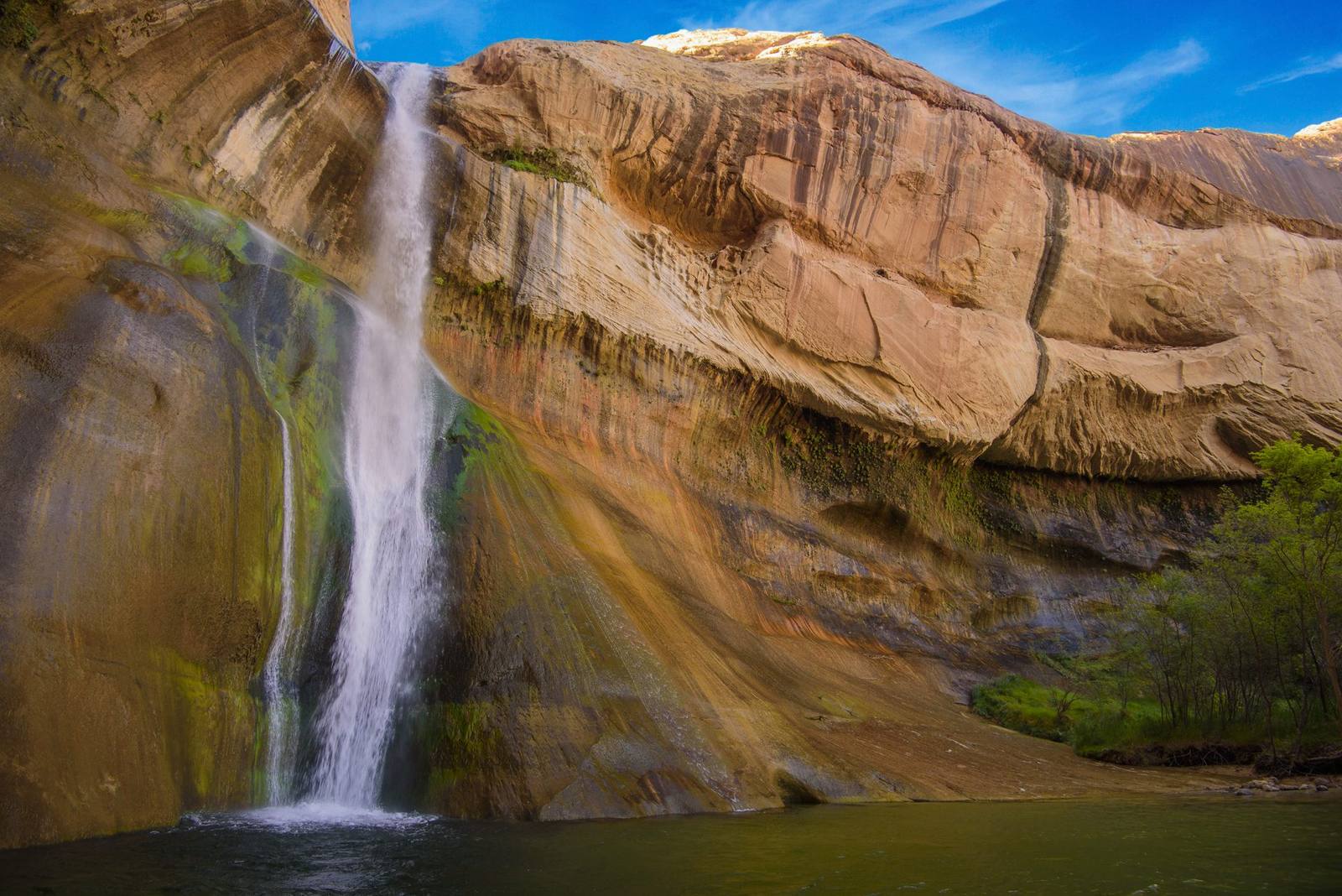
Lower Calf Creek Falls is the hike that ruins you for other desert waterfalls. After walking six miles round trip through a sandy canyon of red and cream sandstone, past ancient granaries and petroglyphs, you round a final bend and a 126-foot ribbon of water drops off a cliff into an emerald pool surrounded by hanging gardens of moss and maidenhair fern. In the middle of the desert. In the middle of a landscape so dry that the creekbed you followed to get here sometimes runs empty. The waterfall should not be here, and yet it is, and it is perfect.
The trailhead sits along Highway 12 between Escalante and Boulder, in the heart of the Grand Staircase-Escalante National Monument. The trail follows Calf Creek downstream through a narrow canyon, crossing the stream several times on sandy banks shaded by cottonwood trees. The walking is not difficult in terms of elevation — the trail is mostly flat — but the deep sand underfoot makes every step heavier than it should be. Wear sturdy shoes and bring more water than you think you need. The canyon walls amplify the heat, and there is limited shade for much of the route.
What makes the hike remarkable is not just the destination but the journey. The canyon walls rise steadily as you walk, shifting from low sandstone benches to towering cliffs of Navajo Sandstone streaked with dark desert varnish. About halfway along, an interpretive sign points out a set of Fremont culture pictographs — dark red figures painted on the cliff face roughly a thousand years ago. A little farther on, high in an alcove on the canyon wall, you can spot small stone granaries where the Fremont people stored corn and other crops. These structures have survived for centuries in the dry desert air, tucked into sheltered niches where rain and wind cannot reach them.
The creek itself is a ribbon of life in an otherwise arid landscape. Cottonwood trees line the banks, their roots tapping the shallow water table. Beaver dams create small pools where minnows dart. Dragonflies patrol the surface. The contrast between the lush riparian corridor and the bone-dry slickrock just a few feet away is a vivid demonstration of how dramatically water changes everything in the desert.
And then you reach the falls. The creek gathers itself at the top of a sandstone cliff and drops 126 feet into a plunge pool that glows an almost unnatural shade of green. The color comes from a combination of dissolved minerals, algae, and the way light interacts with the depth of the pool against the pale sandstone bottom. Mist drifts across the pool, feeding the hanging gardens of fern, moss, and columbine that cling to the cliff face on either side of the falls. The air temperature drops noticeably as you approach — ten degrees, maybe more — and on a hot day the cool mist feels like a gift.
Swimming in the pool is allowed and encouraged, though the water is cold enough to make you gasp. The depth varies with the season and recent rainfall, but the pool is generally deep enough for a full plunge. Floating on your back, looking up at the waterfall and the narrow band of blue sky between the canyon walls, is one of those moments that sears itself into memory. You will remember exactly how the mist felt on your face, exactly how the water sounded hitting the pool, exactly how the green light played across the surface.
The popularity of Lower Calf Creek Falls has grown enormously in recent years, and on peak weekends in spring and fall the parking lot fills early. The Bureau of Land Management charges a day-use fee at the trailhead, and there is a small campground nearby for those who want to stay overnight. Starting early — before 8 AM in the busy seasons — is the best strategy for avoiding crowds on the trail and having the pool to yourself for even a few minutes.
There is also an Upper Calf Creek Falls, reached by a separate and more rugged trail that drops steeply from the highway above. The upper falls are 88 feet high and see roughly a tenth of the traffic of the lower falls. Both are worth seeing, but the lower falls are the main event — the combination of the long, beautiful approach through the canyon and the sudden, dramatic reveal of the waterfall at the end creates a narrative arc that few hikes in Utah can match. You earn this one step by sandy step, and the payoff is everything the desert promises but rarely delivers.
Visitor Info
On the Map
Nearby
The closest stops worth working into your route
Historical markers nearby
Roadside plaques and monuments within a short detour