Home / California / Golden Gate & the Marin Coast / Point Reyes Lighthouse
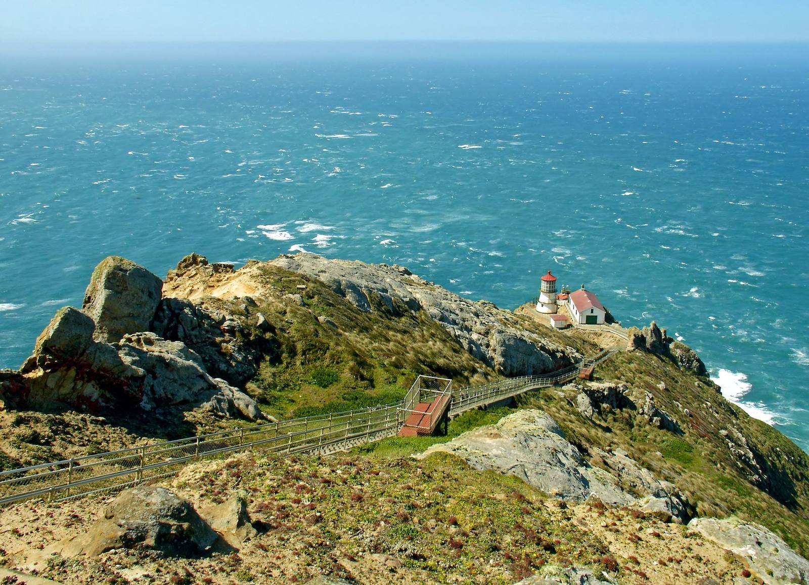
Point Reyes Lighthouse seen from the headland above: the small white tower and red-roofed building sit on a shelf low on the rocky point, a long stairway zigzagging down the slope toward them, with the open Pacific beyond.Masur / CC BY-SA 3.0 via Wikimedia Commons
🏛️Historical

Point Reyes Lighthouse

Part ofGolden Gate & the Marin Coast
On this driveHighway 1: The North Coast

A light set halfway down a cliff on purpose, because that was the only way to get it under the fog.

Iconic
⏱
Duration
One to two hours, plus about forty minutes' drive each way from Olema.
🎟
Admission
Free; the stairs and lens room open on a limited schedule and close in high wind.
📅
Best Season
Winter brings migrating gray whales offshore; summer brings the fog.

The Story

Point Reyes runs ten miles out into the Pacific across the approach to San Francisco, and for as long as ships have come this way it has wrecked them. Getting a light built here took years of lobbying, and the builders had to learn what the coast already knew: a lamp on top of the headland sat inside the high summer fog and showed nothing. So they blasted a shelf about three hundred feet down the cliff face and set the tower there, below the fog.

The tower is short — sixteen-sided, iron plate bolted to the rock — because the cliff supplied the height. Its first-order Fresnel lens, made in France in 1867, first shone on December 1, 1870, flashing every five seconds as a falling weight drove the clockwork. A keeper wound that clockwork through the night, and on foggy days the crew shoveled about 140 pounds of coal an hour into the boiler of the steam fog signal below. The Coast Guard's own record calls the station the windiest and foggiest on the Pacific coast.

When the San Andreas moved on April 18, 1906, the lens slipped off its track. Thirteen minutes later the light was working again. It was retired in 1975.

The way down is more than three hundred steps on the face of the bluff, and the way back up is all of them.

Visitor Info

⏱
Time Needed
One to two hours, plus about forty minutes' drive each way from Olema.
🎟
Admission
Free; the stairs and lens room open on a limited schedule and close in high wind.
📅
Best Season
Winter brings migrating gray whales offshore; summer brings the fog.
🛣️
Highway
Sir Francis Drake Blvd, off CA-1 at Olema

On the Map

Nearby

The closest stops worth working into your route

historical8 mi away
Cypress Tree Tunnel and Coast Station KPH
A radio company's driveway that grew into a tunnel, leading to the coast station that kept Morse code on the air.
cultural12 mi away
Kule Loklo
A Coast Miwok village built in the 1970s to honour a people its builders were told had died out. They had not.
geological13 mi away
Earthquake Trail
A short loop along the San Andreas, where a broken fence shows how far Point Reyes moved in under a minute in 1906.
natural14 mi away
Tomales Point
The northern tip of Point Reyes, where tule elk were fenced in for forty-six years and are fenced in no longer.
historical26 mi away
Muir Beach Overlook
A cliff edge on Highway 1, and the concrete dugouts where two-man crews watched the sea after Pearl Harbor.
natural26 mi away
Muir Woods National Monument
A redwood canyon saved from a reservoir by a gift, and named for a man who had been there once.

Historical markers nearby

Roadside plaques and monuments within a short detour

Marker5.3 mi away
Site of New Albion
Point Reyes Station
Marker15 mi away
Lime Kilns
Olema
Marker16 mi away
Pioneer Paper Mill
Lagunitas
Marker18 mi away
Site of the Lighter Wharf at Bolinas
Bolinas
Marker22 mi away
Bodega Bay and Harbor
Bodega Bay
Marker24 mi away
Home of Lord Charles Snowden Fairfax
Fairfax