The Story
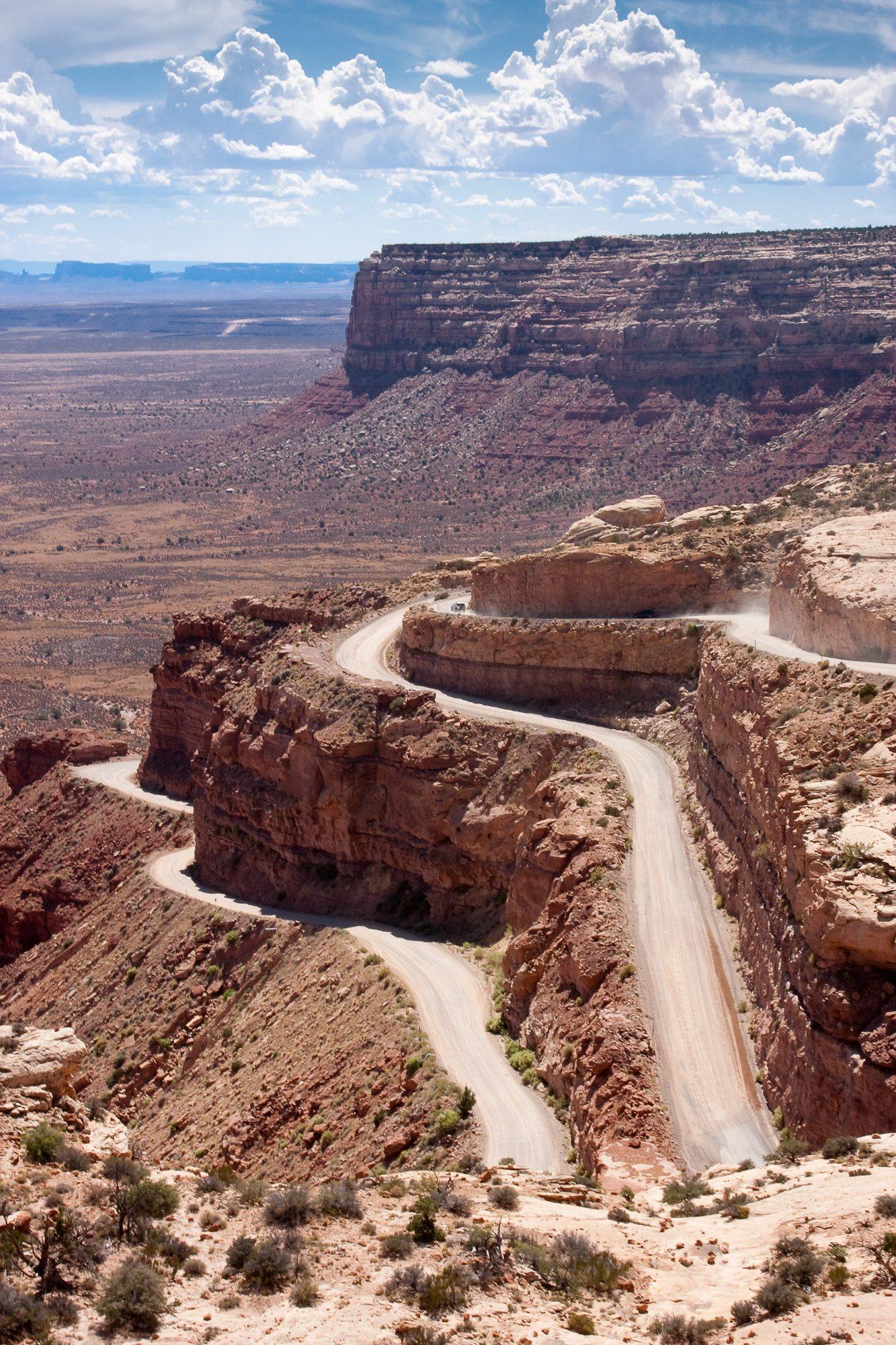
Moki Dugway is three miles of road that will make your palms sweat, your passengers go quiet, and your Instagram followers question your judgment. It is an unpaved series of steep, tight switchbacks carved into the face of Cedar Mesa, descending 1,200 feet from the mesa top to the Valley of the Gods below. There are no guardrails. The drop-offs are real. The road is barely two vehicles wide in places. And the view — the heart-stopping, jaw-dropping, forget-to-breathe view of Monument Valley, the San Juan River canyon, and hundreds of miles of red rock desert spread out below you — is one of the most spectacular driving experiences in the American West.
The road was built in 1958 by Texas Zinc, a mining company that needed a way to haul uranium ore from the Happy Jack Mine on Cedar Mesa down to the processing mill in Mexican Hat. The engineers carved eleven switchbacks into the cliff face using bulldozers and dynamite, creating a route that was functional for heavy trucks but terrifying for everyone else. The mining operation eventually closed, but the road remained, and it has since become a destination in its own right — a pilgrimage route for overlanders, adventure drivers, and anyone who believes that the best roads are the ones that make you feel alive.
The road is graded dirt and gravel, maintained by San Juan County, and passable in a standard passenger car when dry. That said, passable and comfortable are different things. The surface is washboarded in sections, the switchbacks are tight enough to require careful maneuvering in anything larger than a pickup truck, and the exposure on the outer edges of the turns is genuine — you are looking over the side of your vehicle at a thousand feet of nothing. RVs and trailers should not attempt it. Motorcycles and bicycles do, regularly, and the cyclists in particular deserve a special category of respect.
The experience is completely different depending on which direction you drive. Descending from the mesa top, you get the full visual impact immediately — the valley opens up below you as you crest the edge, and each switchback reveals a wider panorama of buttes, mesas, and desert stretching to the horizon. The descent takes about 15 to 20 minutes if you drive cautiously, which you should. Ascending from the valley floor, the experience is more claustrophobic — the cliff face fills your windshield, each turn feels steeper than the last, and you do not see the full view until you reach the top and turn around. Both directions are worth driving if your nerves can handle it.
At the top of the Dugway, a pullout offers a panoramic viewpoint that rivals anything in the national park system. You can see Monument Valley's buttes and mittens to the south, the gooseneck bends of the San Juan River to the east, and the broad red expanse of Valley of the Gods directly below. The silence at this elevation is profound — no traffic noise, no generators, no voices. Just wind across the mesa and the occasional call of a raven riding the updrafts along the cliff face.
The name Moki is a historical term for the Ancestral Puebloan people who inhabited this region for centuries, though the term is considered outdated and sometimes offensive. The Ancestral Puebloans did not build this road, obviously, but they did build communities on the mesa top and in the canyon alcoves throughout this area. Their presence is visible in the ruins, granaries, and rock art panels scattered across Cedar Mesa, many of which are accessible by hiking trails from the mesa-top roads.
The Dugway is best experienced as part of a larger loop through southeastern Utah's most dramatic landscapes. From the top of the Dugway, you can drive south on Highway 261 across Cedar Mesa to Natural Bridges National Monument. From the bottom, Valley of the Gods and Goosenecks State Park are minutes away, and Mexican Hat — the tiny town named after a perfectly balanced sombrero-shaped rock formation on its outskirts — offers gas, food, and a place to let your heart rate return to normal.
There is a philosophical argument embedded in the Moki Dugway experience. Modern road engineering is designed to eliminate surprise, smooth out terrain, and insulate drivers from the landscape they are passing through. The Dugway does the opposite. It forces you to engage with the terrain on its terms — to slow down, pay attention, feel the grade in your steering wheel and the exposure in your stomach. You cannot text on the Moki Dugway. You cannot zone out. You are fully present for every foot of the descent, and by the time you reach the bottom, the landscape has gotten under your skin in a way that no interstate overlook ever could.
That is the trade the Dugway offers. Three miles of discomfort in exchange for a view and an experience you will never forget. It is, by any reasonable measure, an excellent deal.
Visitor Info
On the Map
Nearby
The closest stops worth working into your route
Historical markers nearby
Roadside plaques and monuments within a short detour