The Story
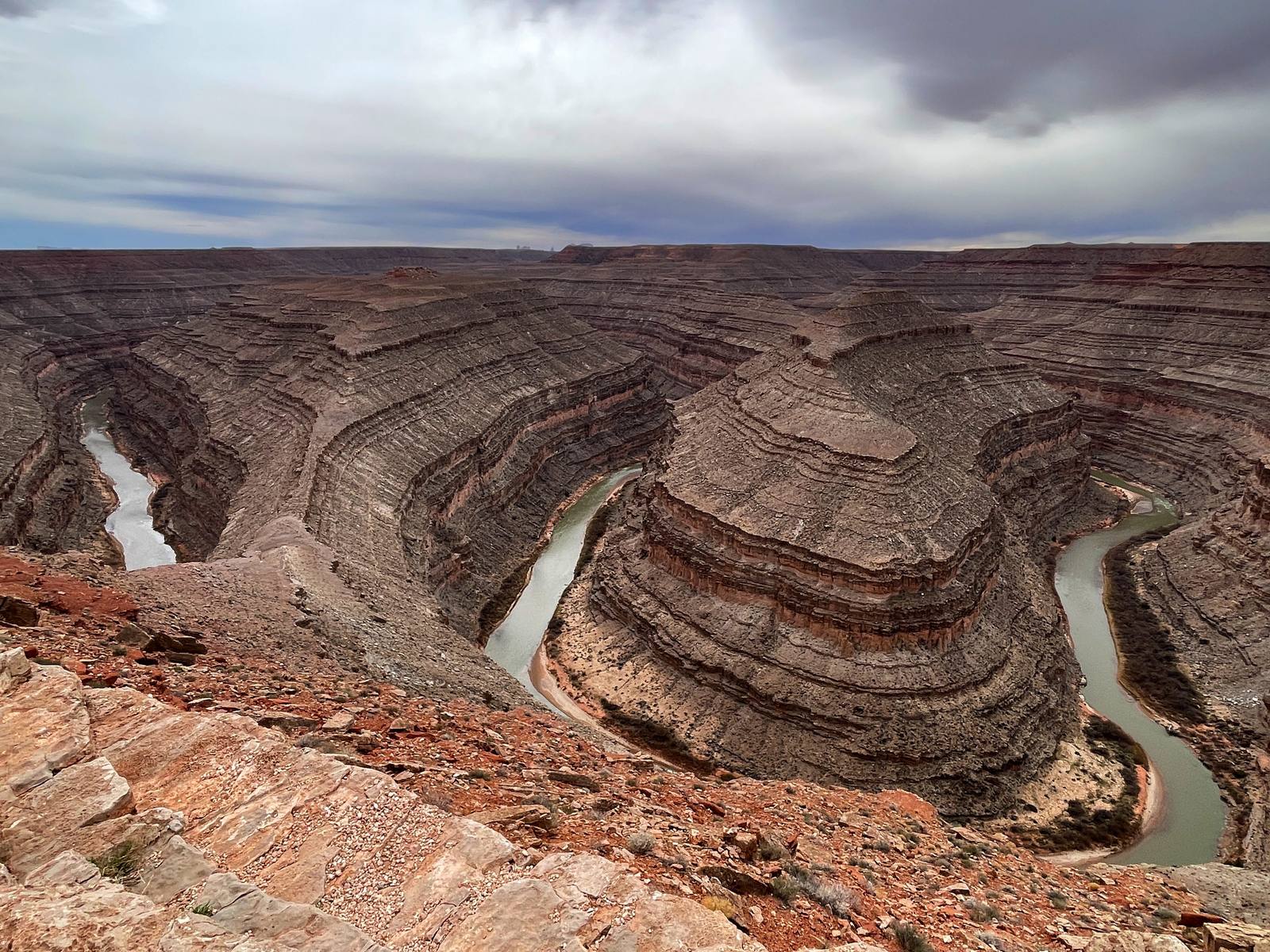
Goosenecks State Park is the simplest park in Utah — a railing, a parking lot, and a view that makes your knees buckle. You pull up, walk thirty feet to the edge, and look down a thousand feet into a canyon where the San Juan River has tied itself in knots. Five enormous meanders — tight, sinuous loops that double back on themselves like a snake trying to swallow its own tail — wind through six miles of river channel while covering only 1.5 miles of straight-line distance. The river is right there below you, green and glinting, but to follow it by boat from the beginning of the first bend to the end of the last would take you four times farther than the canyon is wide. It is one of the most dramatic examples of an entrenched meander anywhere on Earth.
The geology is written on the canyon walls in horizontal stripes. Three hundred million years of Earth history are exposed in the layers of limestone, sandstone, and shale stacked from river level to rim. The oldest visible rocks, near the bottom, date to the Pennsylvanian period — roughly 300 million years ago, when this region was covered by a shallow tropical sea. The younger layers above record advancing and retreating coastlines, desert dune fields, and river floodplains, each deposited in sequence like pages in a book. Standing at the overlook, you are reading that book from top to bottom, and the sheer volume of time represented in those colorful bands is almost impossible to comprehend.
The meanders themselves formed when the San Juan River was flowing across a flat, low-gradient plain millions of years ago. Rivers on flat terrain naturally develop sinuous curves — the physics of flowing water favor meandering over straight channels. As the Colorado Plateau slowly uplifted, the river maintained its winding course while cutting downward into the rising rock, carving the meanders deeper and deeper until they became entrenched in a canyon a thousand feet below the original plain. The river did not choose this path through the rock. It inherited it from a time when the rock was not there.
The park is tiny — barely more than a viewpoint with a few picnic shelters and a vault toilet — but it packs more geological drama per square foot than almost any park in the state. There are no trails descending into the canyon, no visitor center, and no interpretive programs. There is just the railing and the void. This simplicity is refreshing in a state where the national parks can feel like theme parks during peak season. At Goosenecks, there is nothing between you and 300 million years of Earth history except a thousand feet of air.
The light changes everything here. At midday, the canyon walls look pale and washed out, and the river blends into the shadows at the bottom. At sunrise and sunset, the low-angle light catches the horizontal layers and turns them into glowing bands of gold, red, and purple, and the river reflects the sky in its loops. The shadows of the canyon rims creep across the meanders like clock hands, and the entire scene shifts in color and mood over the course of an hour. Photographers who time their visit for golden hour are rewarded with images that look like paintings.
Goosenecks sits just four miles north of Mexican Hat on Highway 316, making it an easy and essential stop on any drive through southeastern Utah. It pairs naturally with the Moki Dugway, Valley of the Gods, and Monument Valley — all within a 30-minute drive — and the combination of these four stops constitutes one of the most visually overwhelming half-days in the American West.
Camping is permitted at the park, and the sites — essentially flat patches of ground near the rim — are first-come, first-served and rarely full. Spending the night here means watching the sunset paint the canyon walls, seeing the stars emerge over the meanders, and waking up to the first light catching the river a thousand feet below your sleeping bag. The facilities are minimal, but the experience is enormous.
There is a temptation to treat Goosenecks as a quick photo stop — pull in, snap a picture, drive away. Resist it. Sit at the edge for twenty minutes. Watch the light change. Follow the river through its loops with your eyes and try to understand the patience required to carve this canyon one grain of sand at a time over 300 million years. The San Juan River is still down there, still meandering, still cutting. It is in no hurry. Neither should you be.
Visitor Info
On the Map
Nearby
The closest stops worth working into your route
Historical markers nearby
Roadside plaques and monuments within a short detour