The Story
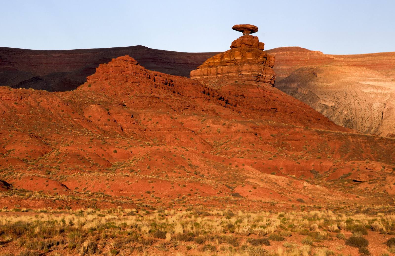
Mexican Hat Rock is a geological sight gag that has been running for millions of years. A broad, flat disc of sandstone — roughly 60 feet wide and shaped unmistakably like a sombrero — sits balanced on a narrow pedestal of softer rock above the tiny town of Mexican Hat, looking for all the world like someone placed it there as a joke and forgot to take it down. The resemblance is not subtle. It is not one of those rock formations where you have to squint and use your imagination. It is a hat. On a head. Made of rock. And it has been sitting there, perfectly balanced, for longer than any hat-wearing civilization has existed.
The formation is a classic example of differential erosion — a hard, resistant caprock protecting softer underlying layers from weathering. The sombrero is a slab of Cedar Mesa Sandstone, a tough, well-cemented rock that resists wind and water erosion effectively. The pedestal beneath it is composed of softer Halgaito Shale, which erodes more quickly, gradually narrowing as the elements strip away material from all sides. The result is a top-heavy formation that looks impossibly precarious but is actually quite stable — the center of gravity sits well within the base, and the physics of the arrangement could sustain the balance for thousands of years to come. Unless an earthquake intervenes, the hat is not going anywhere.
The rock sits on a ridge above the San Juan River, about a mile northeast of the town that borrowed its name. It is visible from Highway 163 as you approach from either direction, though the best views require a short detour up a dirt road that climbs to the base of the formation. A rough parking area at the end of the road puts you within a few hundred feet of the rock, and the walk to the base is short and informal — no maintained trail, just a scramble up the hillside to where the formation stands against the sky.
Up close, the scale is larger than it appears from the highway. The brim of the hat extends well beyond the pedestal on all sides, creating overhangs that cast shadows on the slope below. The rock surface is weathered and pocked, showing the texture of centuries of wind erosion, and the color is the warm tan of Cedar Mesa Sandstone, darkened in places by desert varnish. Standing beneath the overhang, looking up at the underside of a 60-foot stone sombrero balanced on a column of shale, produces a sensation that is equal parts geological appreciation and cartoon physics.
The town of Mexican Hat — population roughly 30 — sits on the north bank of the San Juan River and serves as a launching point for river trips through the Goosenecks and the canyons downstream. The town consists of a few buildings, a trading post, a lodge, and the kind of quiet that only a community of 30 people in the middle of the desert can produce. Its existence is tied entirely to its geography — the river crossing, the proximity to Monument Valley and Valley of the Gods, and the improbable rock formation on the hill above that gave the town its name and its identity.
Mexican Hat Rock is the kind of roadside attraction that the American West does better than anywhere else on Earth. It is not in a national park. It is not managed or interpreted or surrounded by infrastructure. It is just a rock that looks like a hat, sitting on a hill above a town that looks like a crossroads, in a landscape that looks like the backdrop to every Western film ever made. The San Juan River flows past below. Monument Valley's buttes are visible on the southern horizon. The silence is vast. And the hat just sits there, balanced and patient, as it has for millennia, waiting for the next traveler to pull over, look up, and smile.
The formation is best photographed in late afternoon, when the low-angle sun catches the brim and pedestal from the side, casting sharp shadows that emphasize the three-dimensional hat shape. Morning light tends to flatten the formation against the sky, reducing the visual impact. From certain angles at sunset, the rock is silhouetted against the western sky, and the hat shape becomes a black cutout against orange and pink clouds — a natural logo for a town that needed no marketing department to find its brand.
Mexican Hat Rock will never be a major destination. It is too small, too simple, too inherently silly to inspire the reverence that national parks command. But it is a perfect five-minute stop — the kind of place that makes a road trip feel like a road trip rather than a scheduled itinerary. You see the sign. You take the detour. You look at a rock that looks like a hat. You take a photograph. You get back in the car with a smile on your face and a geological curiosity satisfied. That is the transaction, and it is exactly as valuable as it needs to be.
Visitor Info
On the Map
Nearby
The closest stops worth working into your route
Historical markers nearby
Roadside plaques and monuments within a short detour