The Story
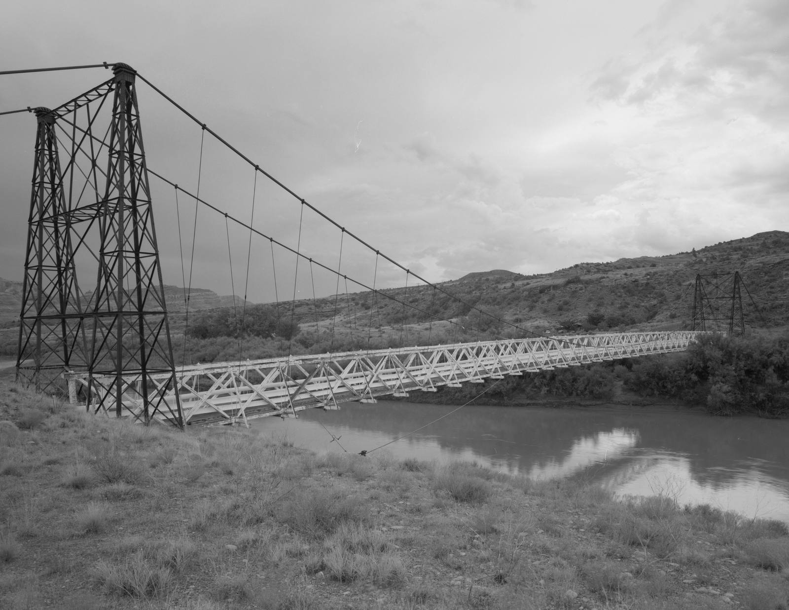
What stands at Dewey today is a skeleton, and that is the point. Two steel towers and a web of cables hang over the Colorado River at the spot where, for ninety-two years, a single-lane wooden deck carried everything southeastern Utah needed across the water, and those bare bones are all that survived the fire that took the rest on a Sunday afternoon in April 2008.
The bridge was finished in 1916, and when it opened it was a genuine event: the towns of Dewey, Cisco, Castleton, and Richardson threw a three-day celebration with a banquet and a dance every night, because the structure meant something close to liberation. Until then, Moab and the other towns of southeastern Utah were tethered to Grand Junction, Colorado — the nearest railhead and supply center — but the river sat between them like a wall, and the only way across at Dewey was a ferry that the little settlement of Kingsferry had grown up around in the 1880s. The Dewey Bridge was the first permanent crossing, the thread that finally stitched the two regions together, and the cattle, freight, and produce that had to reach market now had a way over the river that did not depend on the current.
It was a serious piece of engineering for its day. The Midland Bridge Company of Kansas City built it for about twenty-five thousand dollars — a suspension span 502 feet long and barely eight feet wide from rail to rail, designed to hold six horses, three wagons, and nine thousand pounds of freight at once. At completion it was the longest suspension bridge in Utah and the second longest west of the Mississippi, and it kept that first title until the day it burned. Automobiles and small trucks eventually crossed the same wooden planks the wagons had, one vehicle at a time, until a modern bridge went up alongside it in the late 1980s and the old one was retired from traffic. Grand County restored it in 2000 and folded it into the Kokopelli Trail for cyclists and hikers, and it earned a place on the National Register of Historic Places.
Then, on April 6, 2008, a seven-year-old playing with matches at the campground beside it started a brush fire, and the all-wood deck — ninety-two years old and bone dry — went up. What the flames left behind are the towers and cables you see now, holding up nothing. It is one of only three bridges that cross the Colorado in the four hundred miles the river runs through Utah, which makes the empty frame read less like a ruin than a monument. Pull off at mile marker 30, walk down to the abutment, and study the structure the way you would read Fisher Towers a few miles back toward Moab: as a record of how much effort it once took to get from one side of this country to the other.
Visitor Info
On the Map
A story featuring this place
Go deeper into the history and character of this stop
Nearby
The closest stops worth working into your route
Historical markers nearby
Roadside plaques and monuments within a short detour