Home / Oregon / The North Oregon Coast / Depoe Bay
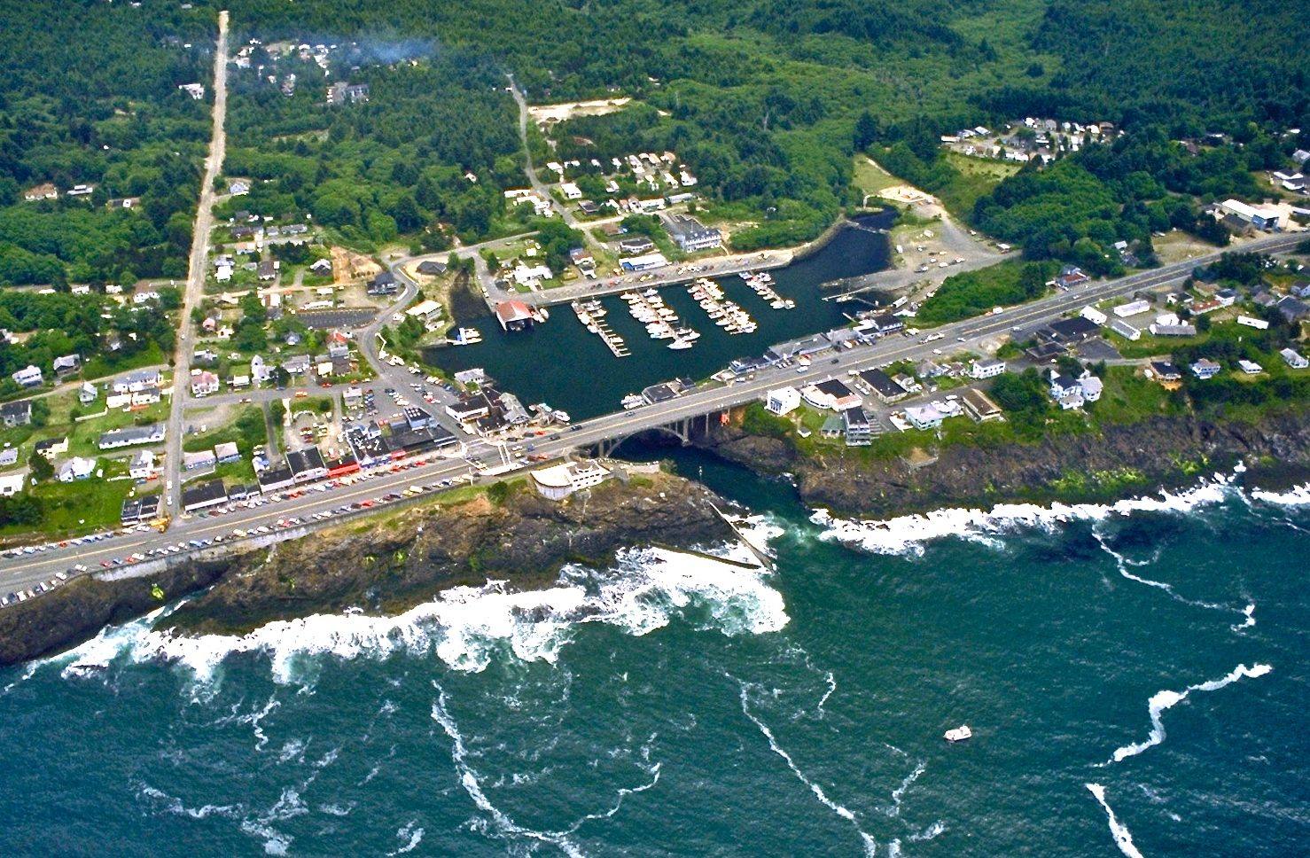
Aerial view of Depoe Bay, the small harbor reached through a rock channel under the US-101 bridgeBob Heims, U.S. Army Corps of Engineers / public domain via Wikimedia Commons
🌲Natural

Depoe Bay

Part ofThe North Oregon Coast
On this driveUS-101 on the North Coast: Astoria to Newport

A six-acre harbor reached through a crack in the basalt, on land allotted in 1894 to a Tututni man the agency knew as Depot Charley.

PhotographyNative American HeritageFree
⏱
Duration
Half an hour on the seawall; a few hours with a boat trip.
📅
Best Season
Late summer and fall for feeding whales close to shore; winter for storms.

The Story

The man the town is named for came from the lower Rogue River. He was Tututni, one of the people forced north onto the Coast Reservation after the Rogue River war, and at the Siletz Agency he was known as Depot Charley, by one account for working at the army depot up the Yaquina near Toledo. The family name later became DePoe. In 1894, under the Dawes Act policy of cutting reservations into individual allotments, he and his family were allotted more than two hundred acres beside a small ocean bay. His heirs sold the last of it in 1923 to a Siletz couple, who sold it on to a real estate speculator, and the town that went up in the late 1920s took the family's name.

The bay is a pocket in the lava with a narrow, dog-legged channel, about fifty feet wide, opening into a harbor of six acres that the town bills as the world's smallest navigable harbor. Charter boats work out of it, and skippers coming in time the swells to run the slot under Conde McCullough's 1927 arch, widened in 1940 because so many drivers stopped on it to look. Walk under the bridge on the stairs from the seawall to watch them.

Gray whales pass on their migrations, and a group of a couple of hundred stays the summer to feed close inshore, often near enough to see from the sidewalk; late summer into fall is the best time. Oregon State Parks staffs a whale watching center on the seawall at the north end of the bridge, free, with binoculars and someone who knows where to look.

Visitor Info

⏱
Time Needed
Half an hour on the seawall; a few hours with a boat trip.
📅
Best Season
Late summer and fall for feeding whales close to shore; winter for storms.
🛣️
Highway
US-101

On the Map

Nearby

The closest stops worth working into your route

natural9.2 mi away
Yaquina Head
A basalt headland with Oregon's tallest lighthouse at the tip and, on its south side, an old quarry the sea was let back into.
culinary48 mi away
Tillamook Creamery
A farmer-owned cheese plant that exists because Tillamook Bay had no good way out, and whose logo is the schooner the settlers built to make one.
historical65 mi away
Champoeg
The river-bend meadow where settlers voted for a government in 1843, and where the Willamette took the entire town but one warehouse eighteen years later.
natural68 mi away
Oregon Dunes
Forty miles of moving sand that Frank Herbert came to write about in 1957, and a government project to stop them that gave him Dune and is now being undone.
natural69 mi away
Silver Falls State Park
Ten waterfalls in a logged-over canyon whose owner once charged a dime admission and pushed junk cars off the edge for the crowd, until a photographer got it made a park.
geological74 mi away
Haystack Rock
A 235-foot sea stack made of lava that ran down the Columbia from the far side of the state, now a nesting rock for tufted puffins.

Historical markers nearby

Roadside plaques and monuments within a short detour

Marker8.3 mi away
Great Tsunami of 1700
Marker13 mi away
Yaquina Bay
Marker28 mi away
Grand Ronde Indian Reservation