The Story
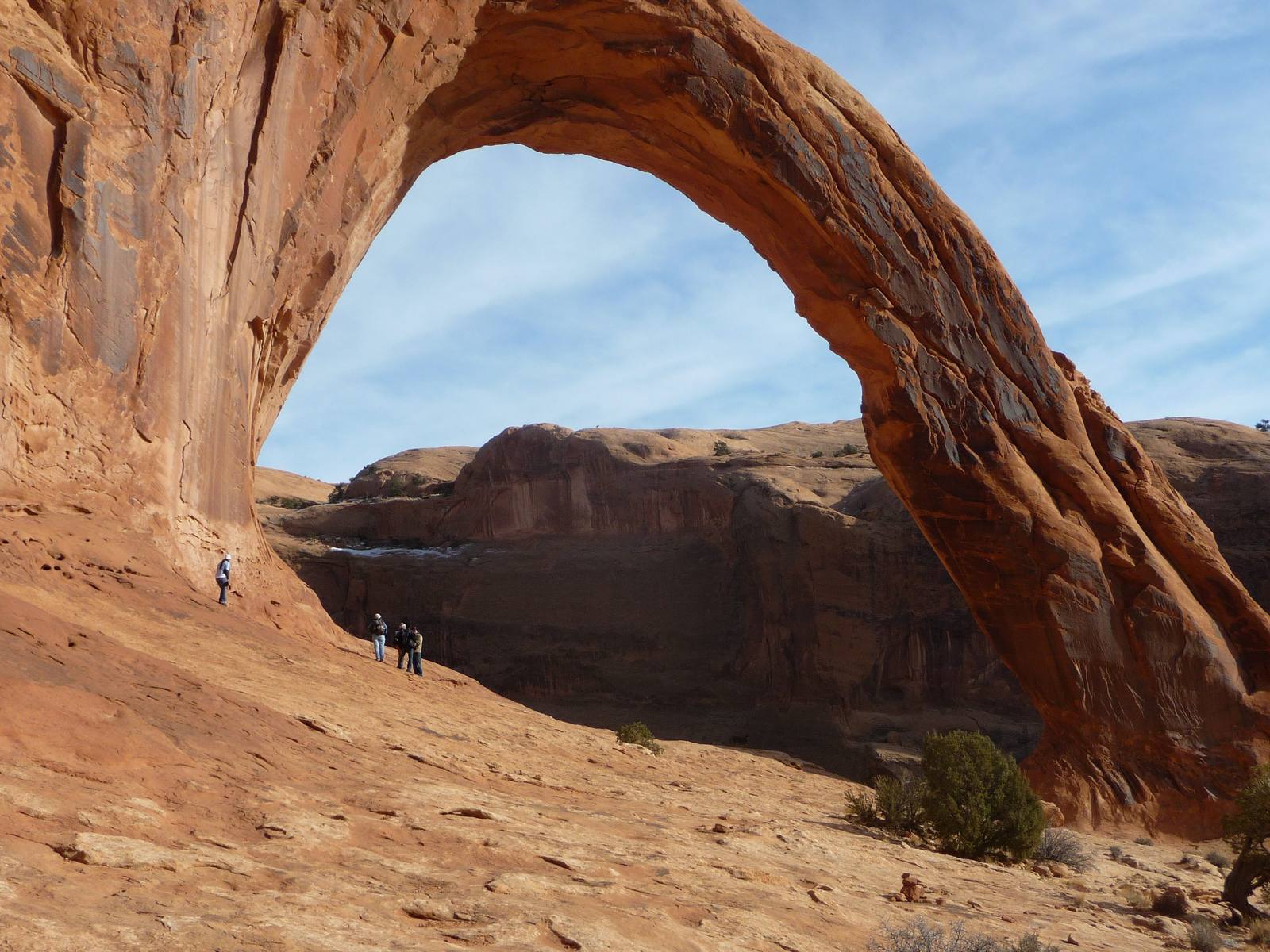
Corona Arch is the arch that Arches National Park wishes it could claim. With a span of 140 feet and a height of 105 feet, it is comparable in size to Delicate Arch — the icon of Utah itself — but it sits on Bureau of Land Management land outside the park boundary, which means no entrance fee, no timed reservation, no crowds jostling for position at a viewpoint. On a weekday morning in the shoulder season, you might have one of the largest natural arches in the Southwest entirely to yourself. That is an increasingly rare experience in southern Utah, and it is worth the short hike to get it.
The trail is three miles round trip, gaining about 400 feet of elevation through a landscape of slickrock, desert scrub, and railroad tracks. Yes, railroad tracks — the first section of the trail parallels and crosses the Union Pacific mainline that runs along the Colorado River corridor, and the sight and sound of a mile-long freight train rumbling past while you hike through red rock desert is one of those only-in-the-American-West juxtapositions that no one plans for but everyone remembers.
Beyond the railroad, the trail climbs through Navajo Sandstone slickrock, following cairns and painted markers across smooth, undulating surfaces. Two short sections require the use of fixed aids — a cable handline bolted into the rock on a steep slickrock ramp, and a short metal ladder on a sandstone ledge. Neither is technically difficult, but both add a tactile engagement with the terrain that most arch-viewing trails lack. You are not walking to an overlook. You are scrambling through the landscape, using your hands, feeling the sandstone under your palms, earning the view in a way that makes the arrival more satisfying.
And then you see it. Corona Arch appears suddenly, framing a section of sky and the distant canyon walls behind it. The arch is massive — the opening is large enough to park a commercial airliner inside — and the shape is a near-perfect parabola, smooth and symmetrical in a way that most natural arches are not. The sandstone is pale cream and salmon, stained with dark streaks of desert varnish, and the play of light through the opening shifts throughout the day. In the morning, the arch is backlit and the interior glows with reflected light from the canyon walls. In the afternoon, direct sun pours through the opening and illuminates the slickrock beneath in a pool of warm gold.
Bowtie Arch, a smaller but equally photogenic arch, is visible from the trail about a quarter mile before Corona. It sits high on the cliff face, a perfect oval of sky punched through the sandstone wall, and it makes an excellent appetizer for the main course ahead. The two arches together make this trail one of the best geological hikes in the Moab area, delivering twice the payoff of most arch trails with none of the national park overhead.
The geology is straightforward. Both arches formed in the Navajo Sandstone, a massive layer of ancient sand dunes turned to stone roughly 180 million years ago. Water seeping through joints and fractures in the rock dissolved the calcium carbonate cement that holds the sand grains together, gradually hollowing out alcoves that deepened and widened over millions of years until they broke through to the other side, creating the openings we see today. Corona Arch is in the prime of its geological life — large enough to be spectacular, thick enough to be stable, and young enough in geological terms that it will likely persist for thousands of years before erosion thins it to the point of collapse.
The trailhead is located along Potash Road (Highway 279), about 10 miles west of Moab along the Colorado River. The drive to the trailhead is scenic in its own right — Potash Road follows the river through a narrow canyon of Wingate Sandstone cliffs, passing dinosaur track sites, rock art panels, and rock climbing areas before reaching the Corona Arch parking lot. Arriving early is advisable on spring and fall weekends, as the small parking area fills quickly.
Corona Arch gained unwanted notoriety in 2012 when a viral video showed a man rope-swinging through the arch opening — a practice that was subsequently banned by the BLM after a fatality. The ban is posted at the trailhead, and the incident serves as a reminder that the forces that make these formations beautiful — thin rock, high exposure, gravity — also make them dangerous when treated as playground equipment.
The arch does not need enhancement. It does not need a rope swing or a drone flyover or a sponsored Instagram post. It needs you to walk three miles through the desert, climb a cable and a ladder, round the final bend, and stand in the shade of 140 feet of natural stone spanning the sky above your head. The silence, the scale, and the absence of crowds create a quality of experience that the national parks are increasingly unable to offer. Corona Arch is the argument for public land at its most persuasive — a world-class natural wonder, free to visit, asking nothing of you but the willingness to walk.
Visitor Info
On the Map
Nearby
The closest stops worth working into your route
Historical markers nearby
Roadside plaques and monuments within a short detour