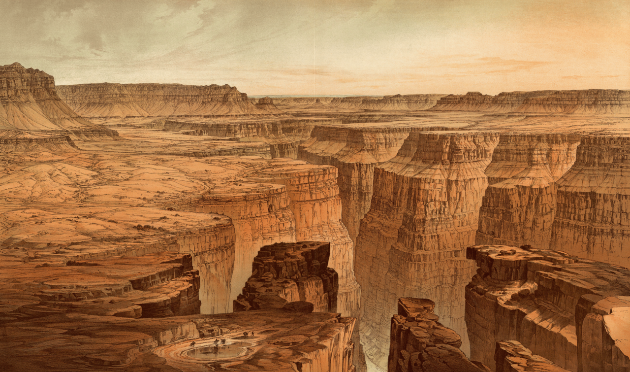
There is a phrase geologists use for what southern Utah does. They call it a layer cake. The image is supposed to make the abstract more digestible — imagine a sliced cake, each tier a different color, each tier a different age. But the metaphor fails the actual landscape. A cake suggests something you look down on, sized to a kitchen. The Grand Staircase is something you look across, sized to a continent.
It stretches from the floor of the Grand Canyon in Arizona, where rocks are six hundred million years old, up through Zion's vertical walls of fossilized sand dunes, up again through the gray badlands of central Utah, and finally up onto the pink limestone hoodoos of Bryce Canyon, the youngest layer in the stack at roughly fifty million years. Five vertical steps. Three states. The deepest readable record of geological time anywhere on the continent, all of it sticking up out of the ground at the same time, all of it visible from the road.
Most of the time, geology is something you have to either dig for or fly over. The Grand Staircase is the rare exception. It tilts up out of the earth at a few degrees, which is just enough that erosion has had something to attack. Over the last twenty million years or so, since the Colorado Plateau began rising in earnest, rivers and ice and wind have cut into the tilted layers and exposed their edges as cliffs.
The result is that what would normally be hidden underground is instead arranged outdoors, in sequence, color-coded, lit from above by Utah sun. You can read it the way you would read the rings of a tree, except the tree is the size of a small country.
This is the story Utah Highway 12 tells when you drive it. The road climbs and drops and climbs again, and at each elevation it cuts through a different layer of the staircase. Most travel writing about Highway 12 treats the scenery as a sequence of beautiful overlooks, which it is. But the overlooks are not separate places. They are different floors of the same building.
The top step
The drive starts, if you come in from the west, at Bryce Canyon. This is the youngest layer of the staircase and the strangest. Bryce is not really a canyon. It is the edge of a high plateau that has been eaten back by ice and rain into thousands of pink limestone spires called hoodoos.
They are made of the Claron Formation, deposited between roughly fifty and sixty million years ago at the bottom of a freshwater lake that covered much of southwestern Utah long after the dinosaurs were gone. The pink color comes from iron oxide in the original lake sediment — the same compound that makes rust, and the same compound that gives human blood its color.
What erodes the hoodoos is not, despite what most visitors assume, wind. It is ice. Bryce sits at over eight thousand feet of elevation, and the temperature swings above and below freezing on roughly two hundred days a year. Water seeps into vertical cracks in the limestone, freezes overnight, expands by nine percent, and pries the rock apart. The hoodoos lose two to four feet of material every century. The amphitheater you see today will be a different amphitheater in a thousand years.
The same Pink Cliff layer also forms Cedar Breaks National Monument, an hour west and less famous, where the same Claron Formation has been carved into a half-mile-deep natural amphitheater that most people drive past on the way to somewhere else.
Descending the steps
Leave Bryce, drive east on Highway 12, and you are descending the staircase. The road drops off the Paunsaugunt Plateau and onto progressively older rock. You pass through the Gray Cliffs, which are Cretaceous shales deposited at the bottom of an inland sea that once split North America in two.
You cross Kodachrome Basin, where pale Entrada Sandstone has been pierced by dozens of vertical rock pipes that no one fully understands — they may be solidified geyser plumbing from a long-dead hot spring field, frozen mid-eruption and then exposed by erosion.
You pass Escalante Petrified Forest, where logs from a Jurassic floodplain were buried in volcanic ash, slowly replaced atom-by-atom with silica, and are now scattered across the hillsides as fragments of stone that still show the original wood grain. Each of these places is a different chapter of the same book, the book being roughly two hundred million years of life and death and shifting climate in what is now southern Utah.
The terrain itself changes as you descend. The vegetation changes. The shape of the light changes. This is not coincidence. Each rock layer weathers differently, holds water differently, supports different soils, supports different plants. The forests of pine and aspen at the top of the staircase give way to pinyon and juniper in the middle elevations, and then to the slickrock barrens of the Escalante canyon country at the bottom. You are not just driving through time. You are driving through the way time shapes everything that lives on top of it.
The ridge that explains itself
About halfway between the towns of Escalante and Boulder, the road climbs onto a ridge so narrow and so high that there is barely room for the pavement and certainly no room for a shoulder. This is The Hogback, and it is one of the few places on the drive where the geology and the engineering of the road are visibly the same thing.
The Hogback exists because of differential erosion — a vertical slab of harder Navajo Sandstone has resisted weathering while the softer rock on either side has been carved away by the Escalante River and its tributaries. The result is a knife-edge of rock with thousand-foot drops on both sides. The road sits on top because the road had nowhere else to sit.
It is the literal embodiment of the principle that runs through the whole staircase: hard rock makes cliffs, soft rock makes slopes, and the shape of the land is just the shape of the difference.
The odd one out
Then, past Boulder, Highway 12 climbs again. It climbs steeply, switchbacking up the flank of Boulder Mountain, and at the top something is wrong with the geology. The rock here is dark. It is heavy. It is volcanic basalt, not sedimentary stone — and it sits on top of the Claron Formation, the same pink limestone you started the drive on at Bryce.
Boulder Mountain is the highest timbered plateau in North America. Its summit reaches over eleven thousand three hundred feet, and the entire top is capped with twenty- to thirty-million-year-old lava flows from a series of volcanic events that geologists are still working out the details of.
As recently as twenty thousand years ago, during the last ice age, the whole summit was buried under an ice cap that spilled glaciers off the rim in every direction. There are glacial striations on the basalt. There are scoured lake basins. The mountain holds eighty lakes, most of them sitting in depressions carved by ice.
This is why Boulder Mountain feels wrong when you climb it after the rest of the drive. It does not match the staircase. It is the staircase plus something else — the staircase with a lid of younger volcanic and glacial events sitting on top, like a hat. It is the reminder that the Grand Staircase is not the only story this landscape tells. It is the loudest one, but the road keeps going up past it.
What it means to drive it
The Grand Staircase took about two hundred and seventy million years to deposit. It took roughly twenty million years to lift, and another several million to erode into its current cliff-and-bench form. Most of that time has no human witness.
The road, by contrast, took a few decades to plan and was not fully paved until 1985. To drive it now, from the Pink Cliffs to the basalt top of Boulder Mountain, takes about three hours if you don't stop. Almost no one drives it without stopping.
The reason is not that the scenery is more dramatic than the scenery on a hundred other beautiful drives. It is that the scenery here happens to also be a legible record of deep time, arranged at a scale and a pace that a human in a car can actually take in. You can stand at Bryce Point in the morning and look out at fifty-million-year-old lake mud carved into spires. You can stand at the summit of Boulder Mountain in the afternoon and look down at twenty-thousand-year-old glacier scratches on volcanic rock. In between, you have driven through every chapter of two hundred and seventy million years.
This is the rarest thing about the road. Not that it is beautiful. Plenty of roads are beautiful. It is that it is beautiful in a way that explains itself, layer by layer, the entire time you are on it.