There is a creek east of Moab that you can smell before you can see it.
It runs out of a side canyon off Highway 128, past the broken red spires of Fisher Towers, and the first thing it does is announce itself — a low, sulfurous, rotten-egg smell that hangs in the dry air and does not belong in slickrock country. The water is called Stinking Spring, and the canyon it drains is named, with the same plain honesty, Onion Creek. Walk its banks and you find something stranger than the smell: actual salt, crusted white along the rock, sitting at the surface in a desert where salt has no business surviving. Rain should have dissolved it and carried it downriver ages ago.
That it is still here is the whole story of why Moab looks the way it does. The smell is a leak, and what it leaks from is the thing that built everything you came to see.
The buried sea
Roughly three hundred million years ago, in the stretch of deep time geologists call the Pennsylvanian, this corner of Utah was a long trough called the Paradox Basin, pinned against the flank of an ancestral mountain range that has since worn entirely away. Seawater spilled into the basin, sat under a desert sun, and evaporated. Then it spilled in again, and evaporated again, and it repeated this in cycles for millions of years — and each cycle left behind the minerals seawater leaves when it dries: gypsum, anhydrite, and ordinary table salt. Stacked over time, those layers became the Paradox Formation, a body of evaporite that runs as much as a thousand feet thick beneath the canyon country and is, in places, sixty-five to eighty-five percent pure salt.
Then the land buried it. Sand seas, rivers, and shallow oceans came and went across the top of the Paradox salt for the next two hundred million years, pressing it down under thousands of feet of the red and tan sandstone the region is famous for today. There the sea should have stayed — a flat, dead bed of salt, sealed away for good.
It did not stay flat. That is the part nobody tells you at the trailhead.
Salt that flows
Salt has a habit that sets it apart from almost every other rock: under pressure, it flows. Bury a layer of sandstone deep enough and it simply packs tighter and grows denser. Salt cannot do this — its crystals have almost no empty space left to squeeze out — so as everything around it grows heavier with depth, the salt stays stubbornly light, and light things buried under heavy things want to rise. Given enough time and enough weight on top, the Paradox salt began to move, oozing sideways and then upward through every crack and weakness in the rock above it, the way warm wax climbs a lava lamp, except over spans of time the mind is not built to hold.
Where the salt gathered and pushed upward, it lifted the overlying rock into long ridges called salt anticlines. Then water finished the job. Wherever a rising salt wall came close enough to the surface for groundwater to reach it, the water did what rain does to salt everywhere — it dissolved it. The support vanished, the arched-up rock above collapsed straight down into the gap, and what was left was a long, flat-floored valley with broken, high-angle faults running down both sides like the seams of a healed wound.
Once you know to look for it, you cannot stop seeing it.
The town in the sunken valley
Start with Moab itself. The town does not sit in a canyon — it sits in a collapsed salt anticline, a valley that exists because a wall of Paradox salt rose here, was dissolved by water working down two parallel faults, and let the ground above it founder. Those faults run the length of the valley and meet near the entrance to Arches National Park, where the highway out of town rides along one of them. Every motel, brewpub, and gear shop in Moab stands on the floor of a hole left by a melted bed of salt.
Arches, a few miles north, is the famous case, and its salt story is told in full on its own page — the short version is that the same rising salt cracked the rock above it into the parallel fins that weather, eventually, into the densest collection of stone arches on Earth. But the arches take all the attention, and the rest of the neighborhood, doing the same work less spectacularly, gets almost none.
The collapse and the spires
Drive northeast along the Colorado and the salt keeps signing its name. Castle Valley — the broad red valley with the freestanding tower that has stood behind a hundred car commercials — is another collapsed salt anticline, faulted down both sides exactly like Moab's, its tall Wingate spires (Castleton Tower, the Priest and Nuns) left standing on the wreckage of the dissolved dome.
A little farther on, Fisher Towers are the salt's strangest sculpture: dark, dripping pinnacles of soft Cutler sandstone capped with harder rock and caked in a stucco of dried red mud, standing on the very salt structure that lifted and broke the ground beneath them. And tucked just behind them is Onion Creek, where we began — the one spot in the neighborhood where the salt did not merely rise and dissolve underground but punched all the way to the surface as a dome called a diapir, and then stayed there, exposed, kept from washing away by the same dry climate that makes the desert a desert. The rotten-egg smell is the closing flourish: as the salt rose it carried up sulfur-rich minerals, and bacteria living in them breathe out the gas that Stinking Spring delivers to daylight.
Even the region's great geological mystery wears the family resemblance. The crater-like swirl of Upheaval Dome, out on the Island in the Sky, was for decades blamed on the salt — taken for a Paradox dome that had risen and collapsed — before most geologists came around to a meteorite instead. Around Moab, salt is simply the first suspect for anything strange in the rock, and it is usually right.
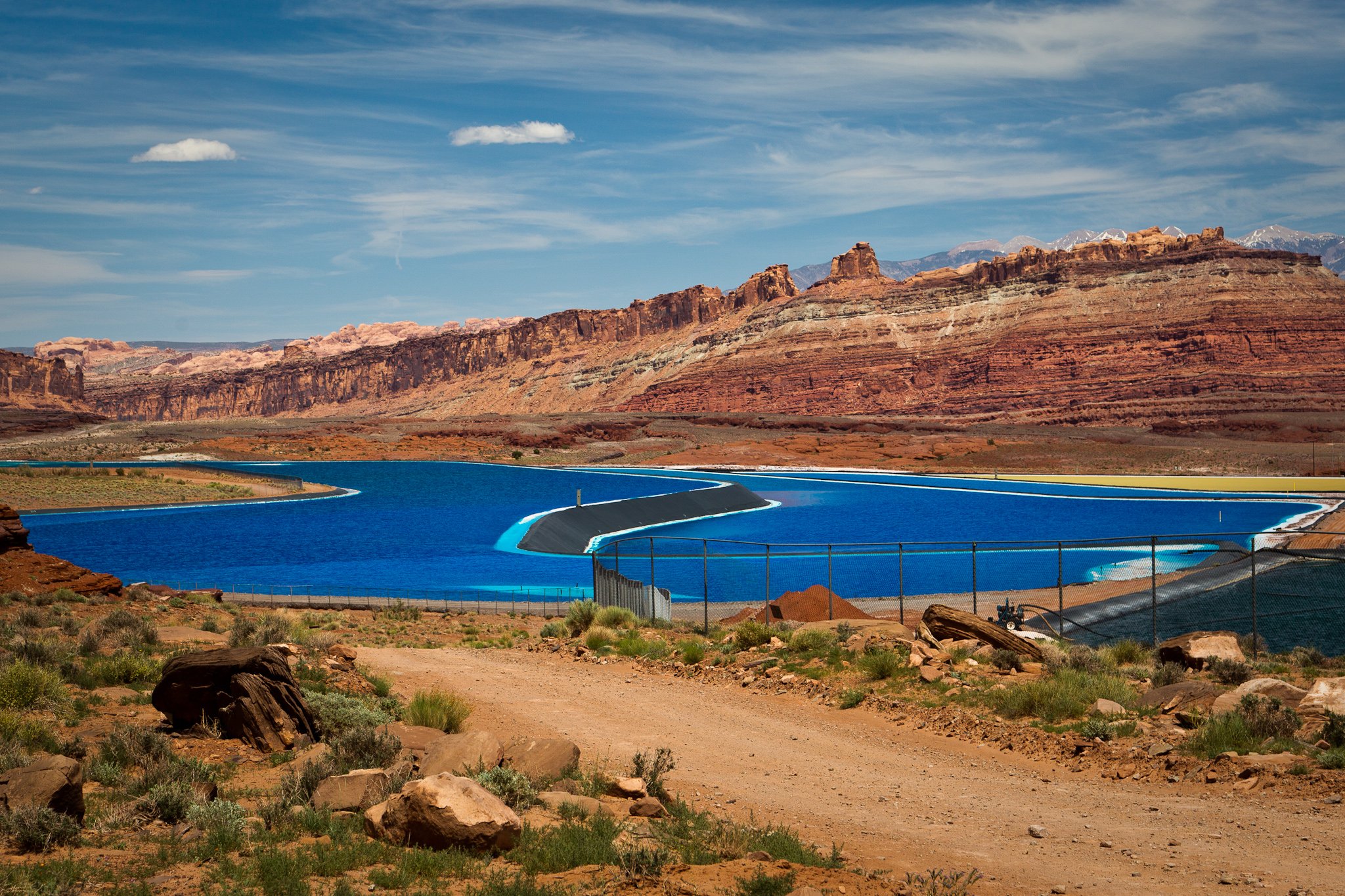
The sea, pumped back up
The strangest proof that the buried sea is still down there is the one you can see from the rim of Dead Horse Point. Look toward the river from the overlook and, set against two thousand feet of red rock, you will find a grid of ponds in an electric, impossible blue.
They are salt. A mining company drills more than three thousand feet down into the same Paradox Formation, injects Colorado River water to dissolve the potassium salts the ancient sea left behind, pumps the brine back to the surface, and spreads it in shallow ponds to let the desert sun evaporate it — exactly the way the sun evaporated the sea that made the salt in the first place. The blue is dye, added to pull in heat and hurry the drying. When the water is gone, the salt is scraped up and carried off as fertilizer.
It is the oldest process in this whole story, run on a three-hundred-million-year delay: an inland sea, dried by the sun, leaving its salt on the ground. The only thing that has changed is that this time someone is doing it on purpose.
That is the thing to carry out of canyon country. The arches and the towers and the sunken valleys are not separate marvels that happen to share a map. They are one marvel — the long, slow, unfinished afterlife of a sea that dried up and never actually left.