Home / Colorado / Denver & the Front Range / Dinosaur Ridge
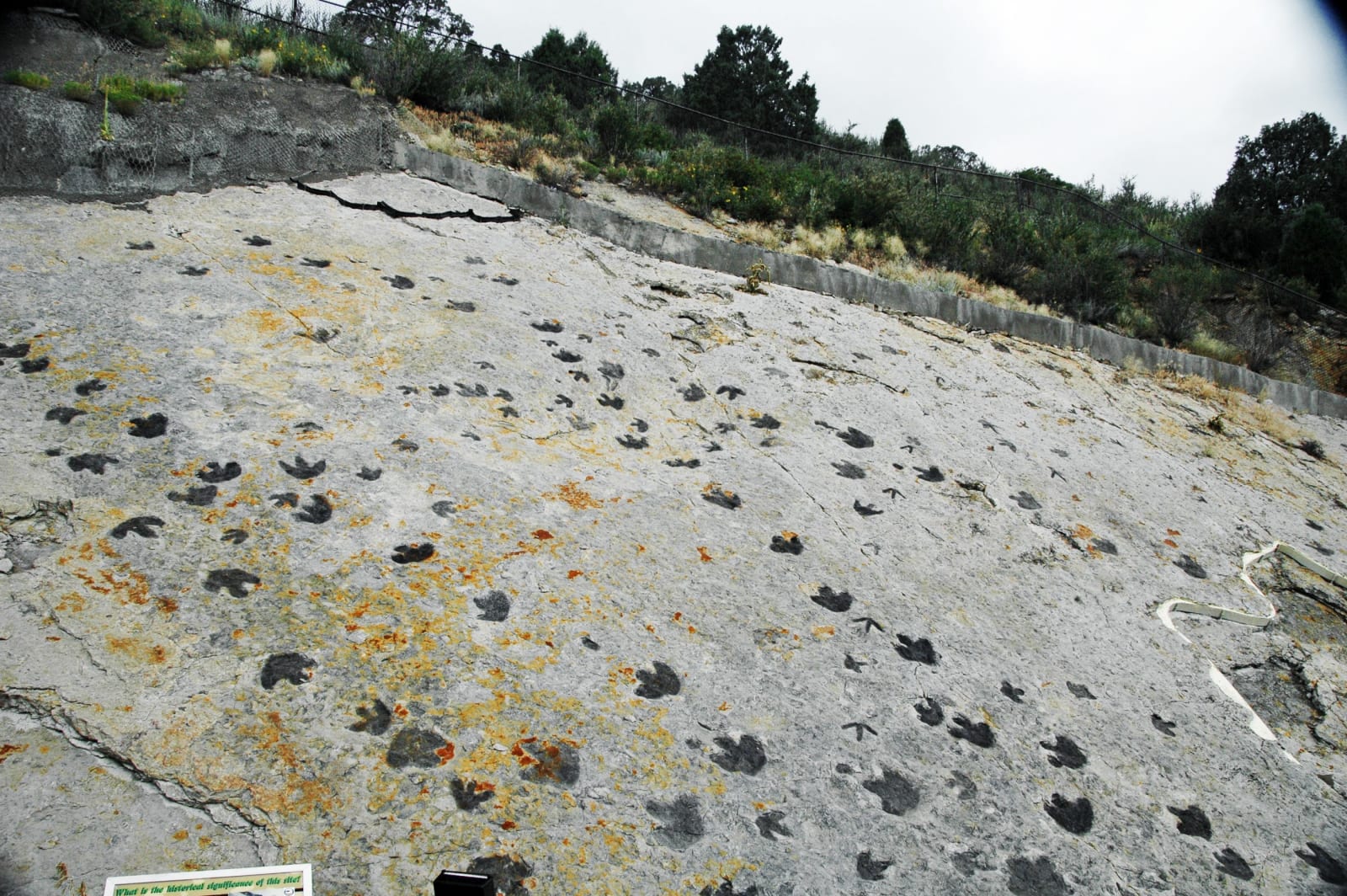
Dinosaur tracks in the tilted Dakota Sandstone on the east face of Dinosaur RidgeJames St. John / CC BY 2.0 via Wikimedia Commons
🏜️Geological

Dinosaur Ridge

Part ofDenver & the Front Range

A hogback near Morrison with the bones of 1877 on one flank and the footprints a road crew blasted open in 1937 on the other.

Year-RoundFamily-FriendlyFossilsDinosaur SitesFreeHiking
⏱
Duration
One to two hours.
🎟
Admission
The trail is free; the bus tours charge.
📅
Best Season
Spring through fall; the trail is open all year.

The Story

Dinosaur Ridge is a hogback, a ridge of tilted rock running north from Morrison along the foot of the Front Range, and its two faces belong to different ages. The west side is Morrison Formation, river and floodplain mud laid down about 150 million years ago, in the Late Jurassic. The east side is Dakota Group sandstone, roughly 100 million years old, left along the shore of the shallow sea that once split the continent.

In March 1877 Arthur Lakes, an English-born teacher in Golden, found bones in the west face. He wrote to O. C. Marsh at Yale and collected for him from quarries along the hogback until 1879, and those quarries gave up the first known remains of Stegosaurus and Apatosaurus. The rock layer took the town's name, so the Morrison Formation that later yielded skeletons from Como Bluff in Wyoming to eastern Utah is named for this place. Stegosaurus has been Colorado's state fossil since 1982.

The east face waited for a road. In 1937, blasting for West Alameda Parkway over the ridge exposed hundreds of footprints in the Dakota sandstone, most of them left by three-toed plant-eaters, along with smaller meat-eaters; later work turned up the first raptor track found in Colorado. Bones are signed along the west side and tracks along the east. Alameda Parkway is closed to public traffic across the ridge and is walked or ridden as a paved trail of about two miles, with guided bus tours from the visitor center. The quarry and the tracks were designated part of a National Natural Landmark in 1973, now the Morrison-Golden Fossil Areas.

Visitor Info

⏱
Time Needed
One to two hours.
🎟
Admission
The trail is free; the bus tours charge.
📅
Best Season
Spring through fall; the trail is open all year.
🛣️
Highway
C-470

On the Map

Nearby

The closest stops worth working into your route

cultural1.8 mi away
Red Rocks Amphitheatre
Walker's Garden of the Titans, finished by the CCC between Ship Rock and Creation Rock and dedicated on June 15, 1941.
architectural11 mi away
Colorado State Capitol
A capitol of Colorado granite, marble, onyx and gold, with three different steps claiming to stand exactly a mile high.
natural19 mi away
Rocky Mountain Arsenal National Wildlife Refuge
Mustard gas, nerve agent and pesticides for forty years, then bald eagles, bison and black-footed ferrets on the same ground.
cultural19 mi away
Central City Opera House
Built by a mining town for itself in 1878, outshone by Tabor within four years, and reopened in 1932 with Lillian Gish.
cultural22 mi away
Colorado Chautauqua
A summer school for Texas teachers that Boulder built in under eight weeks in 1898, still running at the foot of the Flatirons.
natural25 mi away
Mount Blue Sky
Rosalie for a painter, Evans for a governor, and since 2023 a name the Cheyenne and Arapaho asked for, at the top of North America's highest paved road.

Historical markers nearby

Roadside plaques and monuments within a short detour

Marker8.7 mi away
Manhattan Beach
Denver
Marker9.7 mi away
Gold Was Discovered
Denver
Marker9.9 mi away
Camp Weld
Denver
Marker10 mi away
Overland Park
Denver
Marker11 mi away
Elephant Corral
Denver
Marker11 mi away
The Rocky Mountain News
Denver