Home / Alabama / Little River Canyon & Northeast Alabama / Cherokee Rock Village
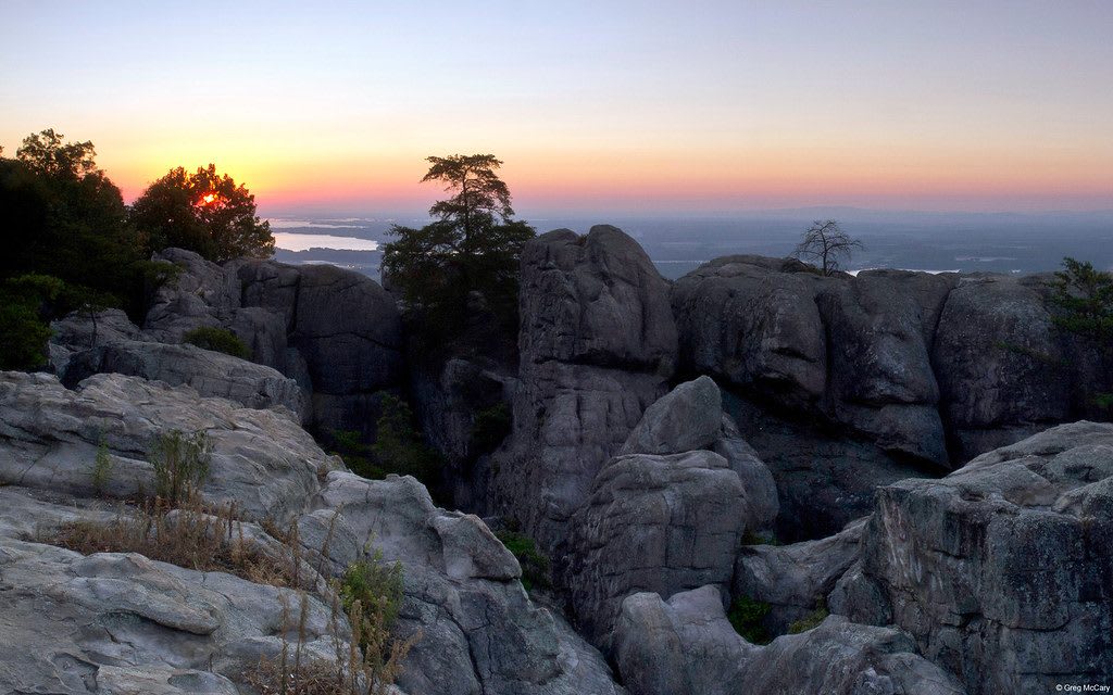
Sandstone blocks and pines at Cherokee Rock Village at sunset, with Weiss Lake in the valley beyond.Juan Alberto Garcia Rivera / CC BY 2.0 via Flickr
🏜️Geological

Cherokee Rock Village

Part ofLittle River Canyon & Northeast Alabama

A county park of house-sized sandstone blocks on the south end of Lookout Mountain above Weiss Lake, a Cherokee place until 1838 and now one of the South's busiest climbing areas.

⏱
Duration
One to three hours.
🎟
Admission
Campsites charge a fee and are first come, first served (2026).
📅
Best Season
October to April for climbing and clear views; summer is hot on the rock.

The Story

On the south end of Lookout Mountain, above the valley of the Coosa, the Pennsylvanian sandstone has broken into a grid of house-sized blocks with slot canyons, arches and overhangs between them; one cluster looks enough like a town that it gave the place its name. People camped here from about 8000 BCE onward. In the last centuries it was Cherokee country, and the site is believed to have held religious and ceremonial meaning. Pathkiller, who led the Cherokee in the Creek War of 1813-14, lived at Turkeytown near present-day Centre, a few miles off. The Cherokee were driven out in 1838 under the Treaty of New Echota, and the old path along the ridge became the settlers' Lookout Mountain Trail.

For years the rocks belonged to the Georgia Kraft paper company, and only climbers came. In 1974 the company gave the county twenty acres around the main formations, and in 1977 the Nature Conservancy bought 200 acres for $15,000 and passed them to Cherokee County. A road came in during the 1980s.

Climbers call it Sand Rock. Bolted sport routes and cracks run up walls as high as 200 feet, and the Southeastern Climbers Coalition looks after the place with volunteer cleanups and an annual competition. Walkers can wander the passages without ropes and come out on ledges over Weiss Lake, which Alabama Power made in 1961. Camping is primitive, with a camp store, a pavilion and restrooms.

Visitor Info

⏱
Time Needed
One to three hours.
🎟
Admission
Campsites charge a fee and are first come, first served (2026).
📅
Best Season
October to April for climbing and clear views; summer is hot on the rock.
🛣️
Highway
AL-68 (Leesburg)

On the Map

Nearby

The closest stops worth working into your route

industrial14 mi away
Cornwall Furnace Park
The best-preserved stone blast furnace of its period in Alabama, built for the Confederacy in 1862 by the Noble brothers of Rome with hundreds of hired-out enslaved laborers.
natural16 mi away
Noccalula Falls Park
A 90-foot waterfall on Black Creek at the edge of Gadsden, in old Cherokee country, carrying the name of a legend that white writers made popular in the 1890s.
natural18 mi away
Little River Canyon National Preserve
An 18-mile sandstone gorge cut by a river that rises and runs almost its whole length on top of Lookout Mountain, in Cherokee country taken at New Echota.
historical19 mi away
Fort Payne Depot Museum
An 1891 sandstone depot in the town that grew around the 1838 stockade where Cherokee families from Willstown were held for removal, now a museum of the valley.
natural24 mi away
DeSoto State Park
A CCC park of stone cabins and lodge on Lookout Mountain, quarried from its own ground, with Alabama's tallest waterfall on a separate tract near Mentone.
natural27 mi away
Lake Guntersville State Park
Six thousand acres of ridge above the TVA lake at Guntersville, once Gunter's Landing, Cherokee land and an 1838 departure point on the Trail of Tears.

Historical markers nearby

Roadside plaques and monuments within a short detour

Marker8 mi away
Pathkiller - Childers - Garrett Ferry
Centre
Marker16 mi away
Congregation Beth Israel
Gadsden
Marker16 mi away
Eleventh Street School
Gadsden
Marker19 mi away
Cherokee Indian Removal
Fort Payne
Marker19 mi away
Fort Payne Opera House
Fort Payne
Marker22 mi away
Site of the Willstown Mission
Fort Payne