Home / Kentucky / Bardstown, Bourbon & Lincoln Country / William Whitley House State Historic Site
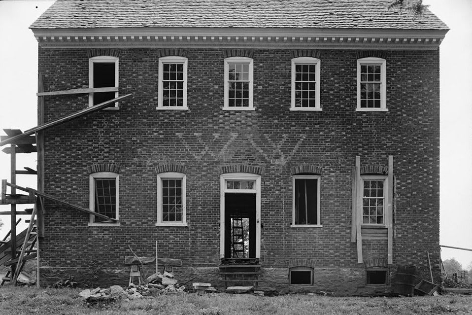
A black-and-white survey photograph of the brick Whitley house front, with the builder's initials W W laid in lighter brick between the floors and scaffolding at one end.Historic American Buildings Survey / public domain via Library of Congress
🏛️Historical

William Whitley House State Historic Site

Part ofBardstown, Bourbon & Lincoln Country

Sportsman's Hill near Crab Orchard, the brick fortress-house William and Esther Whitley built on the Wilderness Road between 1787 and 1794, told from both sides of the frontier war.

⏱
Duration
Thirty minutes to an hour.
🎟
Admission
Free to walk the grounds; ask Lincoln County about house tours (2026).
📅
Best Season
The grounds and trails are open year round, dawn to dusk; the house opens for tours seasonally, as listed by Lincoln County.

The Story

This was Shawnee and Cherokee hunting ground when William and Esther Whitley rode in from Virginia in 1775 with two small daughters, two decades before wagons could use the Wilderness Road. The Shawnee and Cherokee resisted the settlers' spread onto land the British Crown had reserved to Native nations in 1763, and the fighting lasted through the Revolution and beyond. Whitley took a militia colonel's commission and a grant of 10,000 acres, guarded travelers on the road and believed in carrying the fight to Native towns; in 1794 he led about 200 Kentuckians against a Chickamauga Cherokee town in Tennessee.

The house he and Esther built here between 1787 and 1794 is among the first brick houses west of the Alleghenies, and it was made as a fort. Its walls are about two feet thick in Flemish bond, its windows set high, and a hidden stair runs from the kitchen to a bedroom above. Glazed bricks pick out diamonds in the gables and the initials W.W. over the front door and E.W. over the back. In 1788 Whitley laid out a racecourse of clay, run counterclockwise, a break with English custom, and the farm took the name Sportsman's Hill.

At 64 Whitley volunteered again and was killed on October 5, 1813, at the Thames in Ontario, in the battle where the Shawnee leader Tecumseh also fell. The house became a state park in 1938, local people restored it between 1948 and 1955, and Lincoln County has run the site since 2019.

Visitor Info

⏱
Time Needed
Thirty minutes to an hour.
🎟
Admission
Free to walk the grounds; ask Lincoln County about house tours (2026).
📅
Best Season
The grounds and trails are open year round, dawn to dusk; the house opens for tours seasonally, as listed by Lincoln County.
🛣️
Highway
US 150

On the Map

Nearby

The closest stops worth working into your route

cultural13 mi away
Renfro Valley and the Kentucky Music Hall of Fame
John Lair's barn-dance valley off I-75 at Mount Vernon, broadcasting country music since 1939, with the Kentucky Music Hall of Fame in his old riding stable.
historical16 mi away
Berea College
The 1855 school founded by abolitionists, the first integrated, coeducational college in the South, segregated by Kentucky's Day Law from 1904 to 1950.
historical23 mi away
Camp Nelson National Monument
The 1863 Union depot above the Kentucky River where more than 10,000 enslaved men enlisted in the U.S. Colored Troops and their families fought for a place to live.
historical27 mi away
Shaker Village of Pleasant Hill
The hilltop Shaker community of 1806-1910 in Mercer County, with 34 original buildings, a working farm and preserve trails to the Kentucky River.
historical28 mi away
Perryville Battlefield State Historic Site
The field of Kentucky's largest Civil War battle, October 8, 1862, one of the least altered in the country, and the site of the postwar Black community of Sleettown.
historical29 mi away
Mill Springs Battlefield National Monument
The January 1862 battlefield at Nancy, west of Somerset, where Union troops under George Thomas broke the eastern end of the Confederate line across Kentucky.

Historical markers nearby

Roadside plaques and monuments within a short detour

Marker1.7 mi away
On Confederate Routes
Crab Orchard
Marker7.7 mi away
The Cedars
Stanford
Marker8 mi away
County Named, 1780
Stanford
Marker8 mi away
Lincoln County
Stanford
Marker8 mi away
Cherokees in Kentucky
Stanford
Marker8 mi away
Wilderness Road/Logan's Station
Stanford