Home / Kentucky / Lake Cumberland & the Daniel Boone Country / Cumberland Falls State Resort Park
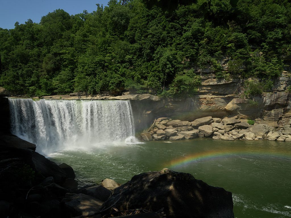
Cumberland Falls pouring over a wide sandstone ledge into a green pool, with a rainbow in the spray and wooded cliffs behind.Carol M. Highsmith / public domain via Library of Congress
🌲Natural

Cumberland Falls State Resort Park

Part ofLake Cumberland & the Daniel Boone Country

The 68-foot falls of the Cumberland River southwest of Corbin, saved from a power plan in 1930 and known for the moonbow that shows in its mist on clear full-moon nights.

⏱
Duration
An hour for the falls and overlooks; a full day with Eagle Falls and the river trails.
🎟
Admission
No entrance fee for the falls and overlooks; lodging, camping and some activities are charged.
📅
Best Season
Year round; spring for high water, and the nights around a full moon for the moonbow.

The Story

The Cumberland River drops about 68 feet over a sandstone ledge some 125 feet wide here, on the line between Whitley and McCreary counties. People have lived along this river for roughly 10,000 years, and Shawnee, Cherokee and Chickasaw people knew this country long before Thomas Walker's party named the river in 1750. The falls began far downstream near Burnside and have cut their way back about 45 miles, carving the gorge you see below the overlooks.

For most of its history the falls were hard to reach. Lewis and Mary Renfro built a cabin here in 1850, and later owners kept a hotel for the few who came. In 1927 the Corbin Kiwanis Club cut a road to the falls by hand, and that same decade came plans to divert the river through a mountain tunnel for hydroelectric power. A preservation campaign persuaded T. Coleman du Pont to buy the falls for the state; after his death his family completed the purchase, the General Assembly accepted it in March 1930, and the park opened in 1931. Three Civilian Conservation Corps companies then built trails, cabins and the first log DuPont Lodge.

The falls face north, and on clear nights near a full moon the moonlight can throw a pale arc through the mist. Kentucky State Parks publishes the moonbow dates each year, and the bow shows best between dusk and midnight. By day, a trail leads downstream to 44-foot Eagle Falls.

Visitor Info

⏱
Time Needed
An hour for the falls and overlooks; a full day with Eagle Falls and the river trails.
🎟
Admission
No entrance fee for the falls and overlooks; lodging, camping and some activities are charged.
📅
Best Season
Year round; spring for high water, and the nights around a full moon for the moonbow.
🛣️
Highway
KY-90

On the Map

Nearby

The closest stops worth working into your route

industrial12 mi away
Stearns and the McCreary County Museum
The Stearns Coal and Lumber Company's town on US-27, with its 1907 headquarters now the county museum and the depot where the Big South Fork Scenic Railway leaves for Blue Heron.
industrial16 mi away
Blue Heron Mining Community
Stearns Coal and Lumber's Mine 18 on the Big South Fork, a coal camp from 1937 to 1962 told through open 'ghost structures' and the recorded voices of the people who lived there.
culinary16 mi away
Harland Sanders Cafe and Museum
The 1940 roadside cafe and motel on old US-25 in North Corbin where Harland Sanders worked out his fried chicken, now a museum with a working KFC attached.
historical24 mi away
Dr. Thomas Walker State Historic Site
A small state site south of Barbourville with a replica of the cabin Thomas Walker's party built in 1750, the first house built by settlers in what became Kentucky.
historical24 mi away
Levi Jackson Wilderness Road Park
A park south of London where walkable stretches of Boone's Trace and the Wilderness Road meet the 1786 McNitt Defeat burial ground, a pioneer museum and McHargue's Mill.
historical25 mi away
Mill Springs Mill
An 1877 gristmill with a 40-foot overshot wheel on the south shore of Lake Cumberland in Wayne County, beside the Confederate ferry landing of the Mill Springs campaign.

Historical markers nearby

Roadside plaques and monuments within a short detour

Marker10 mi away
McCreary County, 1912
Whitley City
Marker10 mi away
First Kentucky Oil Well
Whitley City
Marker12 mi away
Cumberland College
Williamsburg
Marker12 mi away
Scott's Raid
Williamsburg
Marker12 mi away
Gillespie Hall
Williamsburg
Marker12 mi away
Roburn Hall
Williamsburg