Home / Oklahoma / No Man's Land & the Northwest / Alabaster Caverns State Park
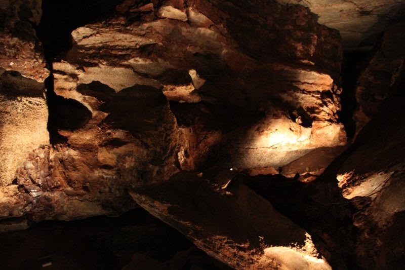
Lit gypsum walls and ledges inside Alabaster Caverns.Matt Howry / CC BY 2.0 via Wikimedia Commons
🏜️Geological

Alabaster Caverns State Park

Part ofNo Man's Land & the Northwest

A three-quarter-mile gypsum cave under Cedar Canyon near Freedom, with selenite, rare black alabaster, five kinds of bats and a past as a 1950s fallout shelter.

⏱
Duration
Two to three hours with a tour and the canyon.
🎟
Admission
A fee is charged for the guided cavern tour; wild caving permits carry a small fee per person.
📅
Best Season
Year round for the cavern tour. Wild caving permits are issued May through September only.

The Story

More than two hundred million years ago, in the Permian, a shallow sea covered this country and dried away, leaving thick beds of gypsum. Water working through the gypsum after it was lifted near the surface cut the cavern that runs under Cedar Canyon here. The Oklahoma Historical Society counts it among the world's largest gypsum caves open to the public: the main passage is three-quarters of a mile long, up to fifty feet high and sixty feet wide, and it stays between 52 and 58 degrees. Its walls hold selenite, white and pink gypsum and rare black alabaster.

Nobody recorded who found it. The first known exploring was in 1898, after Hugh Litton homesteaded the land in the Cherokee Outlet run. In the 1920s and 1930s leaseholders showed visitors the Bat Caves for a small fee, and in 1939 an Englishman, Charles Grass, bought and fixed up the cave and named it Alabaster Caverns. When his health failed, businessmen from Freedom and the Waynoka Railroad Labor League pressed the state to buy it, and Oklahoma paid $34,000 for two hundred acres on September 1, 1953. It became a state park in 1956 and in the mid-1950s served as a fallout shelter.

Up to ten thousand bats of five species use the cave. Guided tours leave on the hour from 9 a.m. to 4 p.m., and the park issues permits for wild caving in four other caves, from 550 to 1,600 feet long, but none from October 1 to April 30, while the bats hibernate.

Visitor Info

⏱
Time Needed
Two to three hours with a tour and the canyon.
🎟
Admission
A fee is charged for the guided cavern tour; wild caving permits carry a small fee per person.
📅
Best Season
Year round for the cavern tour. Wild caving permits are issued May through September only.
🛣️
Highway
OK-50

On the Map

Nearby

The closest stops worth working into your route

geological18 mi away
Little Sahara State Park
More than 1,600 acres of bare, moving dunes south of Waynoka, blown from the Cimarron's Ice Age terraces, begun as a park with two circus camels in 1958.
geological39 mi away
Gloss Mountain State Park
Red buttes of the Blaine Escarpment beside US-412, capped with gypsum whose selenite flashes in the sun, with a trail up Cathedral Mountain and a park kept by its neighbours.
architectural43 mi away
Sod House Museum
Marshal McCully's two-room soddy of 1894 near Aline, the one sod house left in Oklahoma that a homesteader built, under a protective cover where it has always stood.
geological49 mi away
Salt Plains National Wildlife Refuge
About twelve thousand acres of salt flat near Jet where visitors dig hourglass selenite crystals in season, and where the Cherokee Outlet treaty kept the salt open to every tribe.
cultural49 mi away
Pioneer-Krier Museum
Clark County's museum on US-160 in Ashland, where a ranch county's household goods share a wing with the aerobatic biplanes of Harold Krier and the records of miler Wes Santee.
geological49 mi away
Gyp Hills Scenic Drive
A 22-mile loop of mostly gravel road west of Medicine Lodge through red Permian mesas capped with white gypsum, past open range and cedar canyons in a county with more than a hundred cataloged gypsum caves.

Historical markers nearby

Roadside plaques and monuments within a short detour

Marker24 mi away
Fort Supply
Marker26 mi away
Military Road Crossing