Out at the western edge of the Las Vegas Valley, on a patch of ground now called the Springs Preserve, there is a spot where water once came out of the desert hard enough to matter. The Paiute knew it; the Spanish named the whole valley for it; a city of more than two million people grew up around it. They called the largest of the seeps Big Spring, and old-timers swore the upwelling was so forceful that a swimmer could not sink in it. It has not flowed since 1962.
That is the whole story of southern Nevada in one dry spring mouth. This is a place named, in Spanish, for green meadows that no longer exist — Las Vegas means "the meadows" — a desert metropolis whose entire history is a single long argument about water: where to find it, how to spend it, and what to do when it runs short. Every chapter here, from an ancient city on the Muddy River to the concrete wall of Hoover Dam, is written in water, or in the lack of it.
Where the snow sits
The water was never really local. It fell as snow and rain on the high country to the west and north — the Spring Mountains, crowned by Mount Charleston, and the Sheep and Las Vegas ranges — then vanished underground, percolating down through thousands of feet of valley gravel and creeping along buried faults until, pressurized, it pushed back to the surface as artesian springs. Those springs fed a chain of marshes and a mesquite forest in the middle of the Mojave, an oasis so improbable that it became the winter home of the Southern Paiute, who summered in the cool of the Charleston high country and wintered down at the warm springs. The Southern Paiute name for Mount Charleston is Nuvagantu — "where snow sits." The snow that sat there was the meadows' first source.
In 1829 a young scout named Rafael Rivera, ranging ahead of a New Mexican trading caravan bound for Los Angeles, became the first non-Native traveler to ride into the valley, and the name that stuck — Las Vegas, "the meadows" — was a water word from the start. Fifteen years later the explorer John C. Frémont camped at the springs and told the wider world about the good, if too-warm, water in the desert. The meadows were on the map.
The first city the water built
Long before any of them, the water had already built a city here once. Out in the Moapa Valley to the northeast, where the Muddy and Virgin rivers run down toward the Colorado, an Ancestral Puebloan farming culture raised pit houses and many-roomed pueblos and grew corn and beans in the river bottoms — a settlement so extensive that the archaeologists who later uncovered it called it the Lost City. It was the largest such complex west of the Colorado River, and it stood because the rivers were reliable where almost nothing else was. You can see what was saved of it at the Lost City Museum in Overton, built in 1935 atop an excavated pueblo. Keep that name in mind — the Lost City — because the water that made it would also be the water that took it.
The fort, the ranch, the town
When non-Native settlement finally came, it came spring by spring. In 1855 a party of Mormon missionaries built an adobe fort beside the spring-fed creek — the only free-flowing water for miles — and that small outpost, preserved today as the Old Las Vegas Mormon Fort, is the seed the whole city grew from. Out at the foot of the Wilson Cliffs, ranchers settled the one other thing the desert reliably offered: a place where mountain snowmelt surfaced year-round, the green oasis now protected as Spring Mountain Ranch. And when the railroad came through, it chose this valley for the most practical reason imaginable — the springs could water its steam locomotives — and auctioned the Las Vegas townsite in 1905. Fort, ranch, and town: three settlements, one explanation. The water was here, and almost nowhere else.
Running the meadows dry
The trouble began almost at once. Starting in 1907, residents drilled wells straight into the aquifer that fed the springs, and many never capped them, letting the pressurized water gush and run because no one believed it could end. It could. By 1950 the valley was drawing more water from the ground each year than nature put back, and the land itself began to sink, dropping several feet across parts of the valley as the emptying aquifer compacted beneath it. Then, in 1962, after decades of overdraft, Big Spring and the rest of the Las Vegas Springs stopped flowing for good. The meadows that named the city were gone inside a single human lifetime — used up by the very town they had made possible.
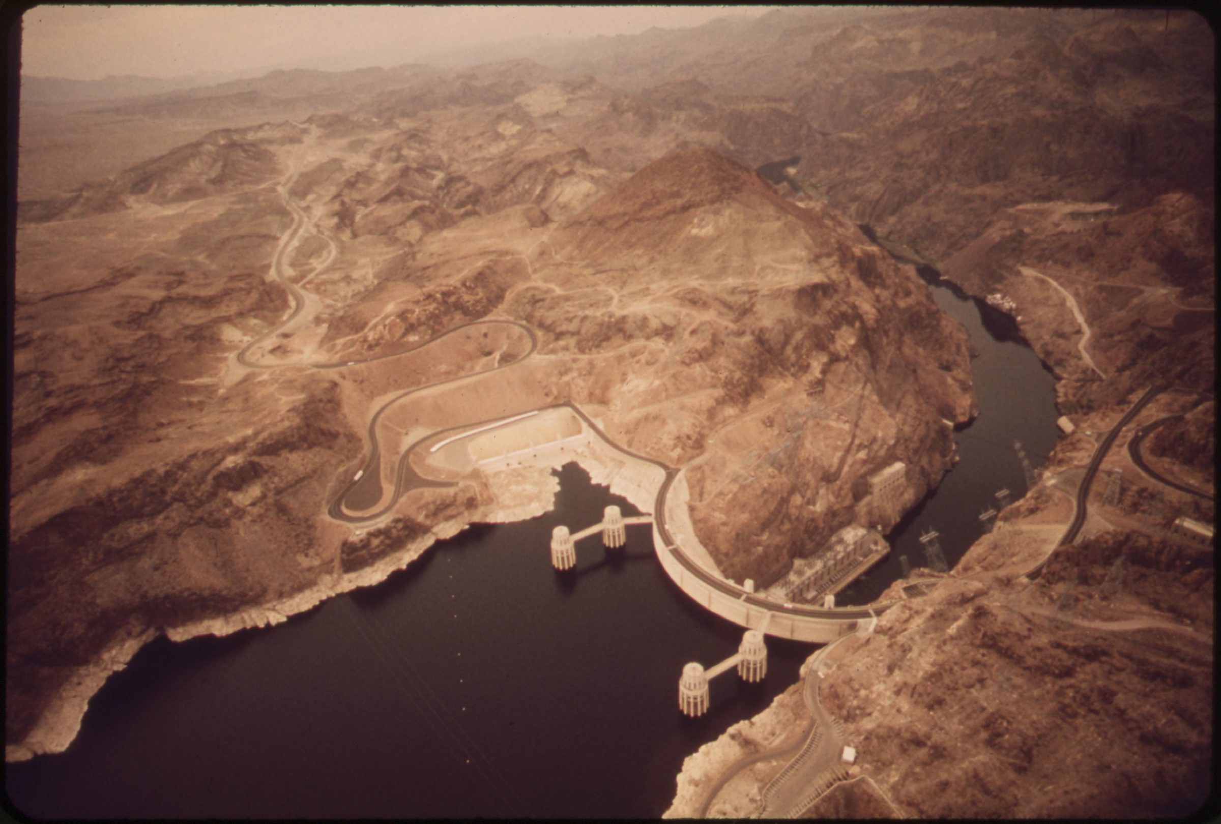
A river for a city
Salvation was already in place, a few miles down the wash. Between 1931 and 1936, in the depths of the Depression, the federal government threw Hoover Dam across the Colorado River in Black Canyon and backed up the largest reservoir in the country behind it — Lake Mead. By 1971 a system of pumps and pipes was lifting that water up into the valley, and today the river supplies about ninety percent of everything Las Vegas drinks. The catch is an old one. When the seven Colorado River states divided the river in the compact of 1922, Las Vegas was a railroad whistle-stop nobody imagined would explode, so Nevada accepted the smallest share of any state — three hundred thousand acre-feet a year. The future thirstiest city in the desert had signed for the shortest straw, decades before it grew the thirst.
What the lake drowned
The river saved the new city, in part, by drowning the old ones. As Lake Mead filled behind the dam, its rising water closed over the Mormon farm town of St. Thomas — whose last resident is said to have rowed away in 1938 — and it backed the Overton Arm up over the heart of the Lost City, submerging the very pueblos the museum had raced to excavate. The reservoir that quenched Las Vegas erased, beneath its own surface, the record of the people who had farmed this water first. For a few decades the trade looked like a bargain.
The bathtub ring
It looks like less of one now. Two decades into the worst drought the Southwest has seen in twelve centuries, Lake Mead has fallen roughly a hundred and eighty feet below its full mark, leaving a blinding white mineral stain — the "bathtub ring" — high on the canyon walls where the water used to reach. The lake sits around a third full and is forecast to drop past its own record lows. The drowned are returning: a sunken World War II landing craft surfaced in 2022, and the stone foundations of St. Thomas now stand in open air. To keep drinking as the reservoir falls, Las Vegas spent roughly one and a half billion dollars boring a "third straw" near the very bottom of Lake Mead — an intake low enough to draw water even below the level at which the dam itself goes dead — and has cut its per-person use by more than half even as the city has grown.
Stand again at that dry spring mouth on the Springs Preserve, where the whole thing began, and the arc is plain. A people named this valley for its water; a city drank that water until the meadows died; then it reached out and drank a river, and now it watches the river's great lake shrink toward the white ring on the rock. The thing that built Las Vegas and the thing most likely to limit it have always been the same thing — the one substance, in all this bright dry country, that no amount of money or neon can manufacture.