Home / Texas / El Paso & the Pass of the North / Tigua Indian Cultural Center, Ysleta del Sur Pueblo
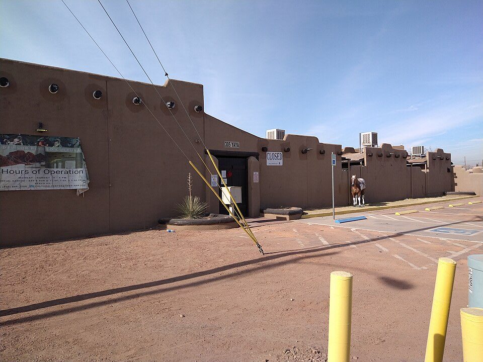
The brown adobe-style walls of the Tigua Indian Cultural Center at Ysleta del Sur Pueblo in El Paso.Sue Barnum / CC BY-SA 4.0 via Wikimedia Commons
🎭Cultural

Tigua Indian Cultural Center, Ysleta del Sur Pueblo

Part ofEl Paso & the Pass of the North

The cultural center of Ysleta del Sur Pueblo, the Tigua nation that has lived in the Mission Valley of El Paso since 1682 and keeps its own history here.

⏱
Duration
One hour.
🎟
Admission
Check with the Pueblo for current hours and any fees.
📅
Best Season
Year round. Feast days and events follow the Pueblo calendar.

The Story

Ysleta del Sur Pueblo is a federally recognized, sovereign Native nation inside the city of El Paso, and its people are known as the Tigua. The Pueblo tells its beginning this way: Tigua families left their homelands at Quarai Pueblo because of drought and took refuge at Isleta Pueblo in New Mexico. During the Pueblo Revolt of 1680 they were captured by the Spanish and forced to walk more than 400 miles south. In 1682 they established Ysleta del Sur, the Ysleta of the south, and soon after dug the acequia, the irrigation canal that made the valley a farming community.

The Pueblo's land base shrank through the nineteenth century. In 1751 the king of Spain granted the Pueblo thirty-six square miles around the mission, and Texas recognized the grant in 1854, but through state acts and land promoters the Pueblo lost almost all of it. Texas recognized the Tigua as a tribe in 1967, and the federal government did so the next year.

The Tigua Indian Cultural Center is the Pueblo's own place for its history and culture, and the Pueblo describes it as a collective site for centuries of tribal history. It stands on Yaya Lane in the old part of Ysleta, a short drive from the mission church the Tigua know as San Antonio. Visitors come as guests of a living community: check the Pueblo's site for hours and events, and ask before taking photographs.

Visitor Info

⏱
Time Needed
One hour.
🎟
Admission
Check with the Pueblo for current hours and any fees.
📅
Best Season
Year round. Feast days and events follow the Pueblo calendar.
🛣️
Highway
Alameda Avenue (TX-20) / Zaragoza Road

On the Map

Nearby

The closest stops worth working into your route

architectural0.8 mi away
Ysleta Mission (Corpus Christi de la Ysleta del Sur)
The Tigua mission church at Ysleta, rebuilt in 1908 around the walls, bell and Santo Entierro that came through fire, its interior painted with rain clouds and corn.
architectural1.9 mi away
Socorro Mission (Nuestra Senora de la Limpia Concepcion del Socorro)
Socorro's adobe church on the El Paso Mission Trail, with walls five feet thick, carved vigas from an older church and a statue of Saint Michael said to have chosen the town.
historical7.3 mi away
San Elizario Historic District
A plaza of adobe buildings at the end of the El Paso Mission Trail: an 1877 chapel, Gregorio Garcia's portaled house and the old county jail of Billy the Kid legend.
historical9.9 mi away
Chamizal National Memorial
A park on land the Rio Grande once put in dispute, where a century-old border quarrel between the United States and Mexico was settled by treaty and a new concrete channel.
historical11 mi away
Magoffin Home State Historic Site
A U-shaped adobe of the 1870s in central El Paso that joins Mexican building to an Anglo plan, closed for restoration through 2027 while its visitor center stays open.
natural21 mi away
Franklin Mountains State Park
Almost 27,000 acres of desert mountains inside El Paso, with the oldest rocks in Texas, more than 100 miles of trail and campsites in the Tom Mays Unit.

Historical markers nearby

Roadside plaques and monuments within a short detour

Marker0.7 mi away
Alderete-Candelaria House
El Paso
Marker0.8 mi away
Oldest Mission in Texas
Ysleta
Marker0.8 mi away
Corpus Christi de la Ysleta
Ysleta
Marker1.9 mi away
The Camino Real
Socorro
Marker1.9 mi away
Socorro
Socorro
Marker1.9 mi away
Socorro Mission La Purísima
Socorro