Home / North Carolina / Fayetteville, Pinehurst & the Sandhills / Lumber River State Park (Princess Ann Access)
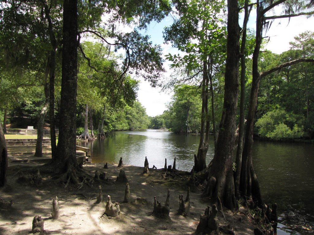
The dark, still Lumber River framed by cypress trees and knees along a shaded bank.Gerry Dincher / CC BY-SA 2.0 via Flickr
🌲Natural

Lumber River State Park (Princess Ann Access)

Part ofFayetteville, Pinehurst & the Sandhills

The blackwater river the Lumbee are named for, which many Lumbee people call the Lumbee River, with landings, campsites and trails at Princess Ann.

⏱
Duration
Two hours to a full day on the water.
🎟
Admission
Free for day use; fees for camping (NC State Parks, 2026).
📅
Best Season
Spring and fall for paddling. Park hours run from 7 a.m. to between 6 and 9 p.m. depending on the month (NC State Parks, 2026).

The Story

The Lumbee take their name from this river, and many Lumbee people call it the Lumbee River. On older maps it is Drowning Creek. The tribe describes itself as an amalgamation of Siouan, Algonquian and Iroquoian-speaking peoples; a trade commissioner's map of 1725 placed four Siouan-speaking communities in the area, the Saraw, Pedee, Scavano and Wacoma, and in 1754 a settlement of fifty Indian families was reported on Drowning Creek. Land records from the later 1700s show families since identified as ancestral Lumbee taking title along the creek and the swamps that feed it.

Those swamps sheltered people the Confederacy tried to conscript to build forts on the Cape Fear. In March 1865 the Home Guard held a drumhead trial of Allen Lowry and his son William, accused of keeping guns that free people of color had been forbidden to own, and shot them. Allen's son Henry Berry Lowry led a band, Native, Black and white, that held out against the authorities in this country until 1872.

The river runs 115 free-flowing miles from the meeting of Drowning Creek and Buffalo Creek near Wagram to the Little Pee Dee in South Carolina, dark with tannins from the swamps. It is the only blackwater river in the state designated a National Wild and Scenic River, and the state made it a park in 1989. Princess Ann, named for a riverside town chartered in 1796 and long gone, has the landings, nine campsites and short trails. Belted kingfishers work the banks.

Visitor Info

⏱
Time Needed
Two hours to a full day on the water.
🎟
Admission
Free for day use; fees for camping (NC State Parks, 2026).
📅
Best Season
Spring and fall for paddling. Park hours run from 7 a.m. to between 6 and 9 p.m. depending on the month (NC State Parks, 2026).
🛣️
Highway
Princess Ann Road

On the Map

Nearby

The closest stops worth working into your route

natural17 mi away
Little Pee Dee State Park
A quiet park on the blackwater Little Pee Dee River near Dillon, with a Carolina bay and its sand rim and a 54-acre lake for fishing and paddling.
roadside19 mi away
South of the Border
The faux-Mexican roadside stop on the North Carolina line, built from a 1950 beer stand into a 350-acre complex advertised by hundreds of miles of billboards.
cultural23 mi away
Museum of the Southeast American Indian at Old Main
The 1923 brick building at UNC Pembroke that Lumbee people fought to save, burned in 1973 and rebuilt, now home to a free museum of Native Southeast life.
historical30 mi away
Battle of Hayes Pond
The field near Maxton where several hundred Lumbee people broke up a Ku Klux Klan rally on January 18, 1958, marked by a state roadside marker.
natural31 mi away
Jones Lake State Park
A rain-fed Carolina bay north of Elizabethtown, opened in 1939 as the first North Carolina state park to welcome Black visitors.
natural32 mi away
Lake Waccamaw State Park
The largest Carolina bay, buffered by limestone and home to aquatic species found nowhere else, near the Waccamaw Siouan homeland at the edge of the Green Swamp.

Historical markers nearby

Roadside plaques and monuments within a short detour

Marker14 mi away
Camp Victor Blue
Nichols, South Carolina
Marker15 mi away
Thompson Institute
Lumberton
Marker19 mi away
Mt. Olive Baptist Church
Mullins, South Carolina
Marker19 mi away
Tobacco Culture
Mullins, South Carolina
Marker20 mi away
Millie-Christine McKoy
Whiteville
Marker21 mi away
Burnt Swamp Association
Lumberton