Home / Nebraska / North Platte & the Great Platte River Road / Lake McConaughy and Kingsley Dam
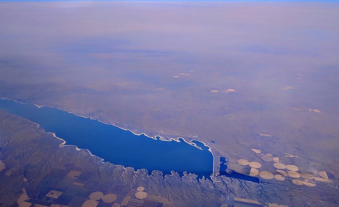
Lake McConaughy seen from the air, its white sand shoreline running to Kingsley Dam beside circles of irrigated fields.Dicklyon / CC BY-SA 4.0 via Wikimedia Commons
๐Ÿ•๏ธRecreational

Lake McConaughy and Kingsley Dam

Part ofNorth Platte & the Great Platte River Road

Nebraska's largest reservoir, 22 miles of North Platte water and white sand beaches behind a 1941 hydraulic-fill dam, built so farms far downstream could water their crops.

โฑ
Duration
An hour at the dam and visitor center; a day or more on the beaches.
๐ŸŽŸ
Admission
A Nebraska park entry permit is required.
๐Ÿ“…
Best Season
Summer for the beaches. Visitor center open daily 8 to 6 Mountain Time from May 20 to Sept. 10, and 8 to 4 the rest of the year.

The Story

Lake McConaughy is the largest reservoir in Nebraska, 22 miles long on the North Platte above Ogallala, and it was built for farms well over a hundred miles downstream. The idea belonged to C. W. McConaughy, a Holdrege grain merchant and mayor, who began arguing in 1913 for putting Platte River water on south-central Nebraska farmland in spring and fall so the soil would carry the crops through summer. George P. Kingsley, a Minden banker, heard him speak and worked for the project until his death in 1929.

The Legislature created the Central Nebraska Public Power and Irrigation District on July 1, 1933, and the Tri-County project won federal approval in 1935. Private power companies fought it, and a lawsuit kept the district from sending water outside the Platte basin, taking away almost two-thirds of the planned acreage. The district moved its storage to a larger site north of Ogallala, where it could sell more electricity. Kingsley Dam went up from 1936 to 1941 on a PWA grant and a federal loan, loess and water pumped into a hydraulic fill 162 feet high and more than three miles long, faced with about 180,000 Wyoming limestone jackstones. McConaughy died on April 15, 1941, months before the dedication.

The lake irrigates about 109,000 acres through more than 500 miles of canals, and a hydro plant at the dam has run since 1984. The visitor center, a quarter mile south of the dam on Highway 61, has aquariums and films of the dam being built.

Visitor Info

โฑ
Time Needed
An hour at the dam and visitor center; a day or more on the beaches.
๐ŸŽŸ
Admission
A Nebraska park entry permit is required.
๐Ÿ“…
Best Season
Summer for the beaches. Visitor center open daily 8 to 6 Mountain Time from May 20 to Sept. 10, and 8 to 4 the rest of the year.
๐Ÿ›ฃ๏ธ
Highway
NE-61

On the Map

Stories

A story featuring this place

Go deeper into the history and character of this stop

Nature
The Birds of the Gravel Pits
Open Road Guide ยท 3 min read

Nearby

The closest stops worth working into your route

historical25 mi away
Ash Hollow State Historical Park
The emigrants' spring below Windlass Hill, six miles from the Blue Water Creek camp where Harney's soldiers killed eighty-six Lakota in 1855, and where their belongings came home in 2025.
architectural26 mi away
Pilgrim Holiness Church (Baled Hay Church)
A church raised in 1928 from bales of hand-tied rye straw in treeless Arthur, the oldest known straw-bale church in North America and a survivor of a Sandhills building habit.
historical35 mi away
Julesburg
The town that moved four times: a trading post, a stage stop burned in 1865, the wickedest end-of-track town on the Union Pacific, and finally Denver Junction renamed.
industrial44 mi away
Golden Spike Tower and Bailey Yard
A tower with seventh- and eighth-floor decks over Union Pacific's Bailey Yard in North Platte, the world's largest railroad classification yard, in a town the railroad laid out and fed troops from.
historical45 mi away
Buffalo Bill Ranch State Historical Park
Scout's Rest, the North Platte ranch house and barn of William F. Cody, in the town where his Old Glory Blowout of July 4, 1882 became the first act of the Wild West.
industrial51 mi away
Champion Mill
A water-powered flour and feed mill on Frenchman Creek, running on creek water since 1888 and rebuilt after an 1891 fire, beside a creek that irrigation wells have drawn down.

Historical markers nearby

Roadside plaques and monuments within a short detour

Marker23 mi away
Phelps Hotel
Marker23 mi away
Waterman Sod House
Marker23 mi away
Sam Bass and the Big Springs Robbery
Marker24 mi away
Windlass Hill Pioneer Homestead
Marker24 mi away
Colorado's Northeast Corner
Julesburg, Colorado
Marker25 mi away
Ash Hollow