Home / Georgia / Macon, Milledgeville & Middle Georgia / High Falls State Park
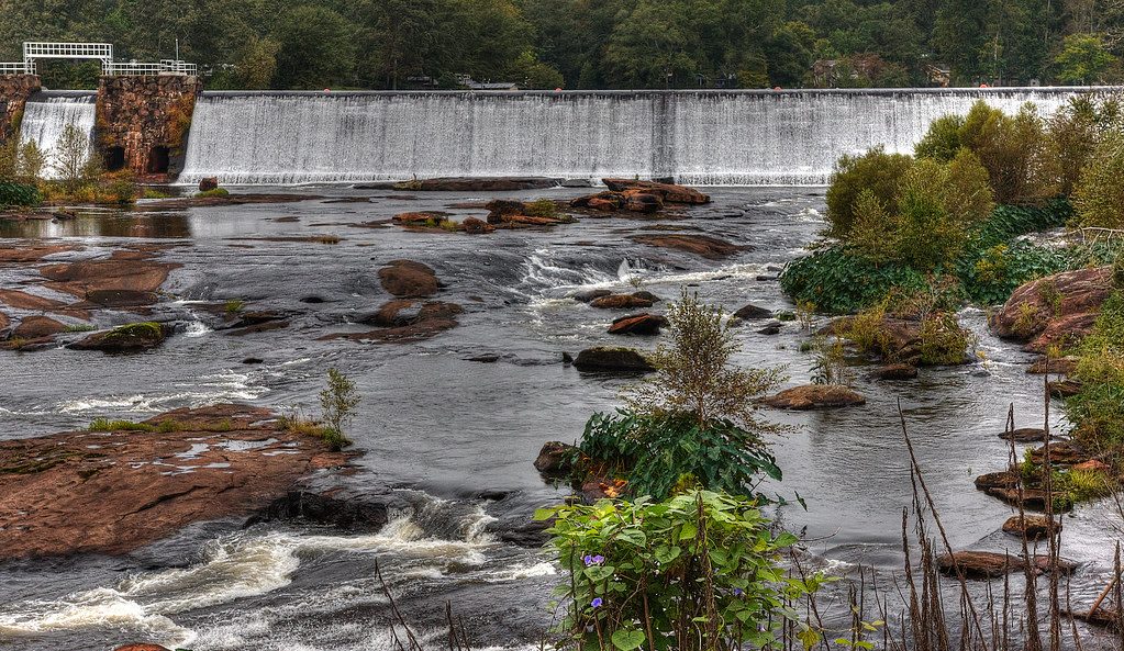
A wide river spilling over a long dam and tumbling across red-brown rocks and shoals, with green brush in front.Stephen Rahn (StephenGA) / CC0 via Flickr
🌲Natural

High Falls State Park

Part ofMacon, Milledgeville & Middle Georgia

Cascades on the Towaliga River northwest of Macon, with the ruins of a mill town the railroad passed by and a lake known for white and hybrid bass.

⏱
Duration
One hour to a full day.
🎟
Admission
Daily ParkPass parking fee per vehicle; annual passes available (Georgia State Parks, 2026).
📅
Best Season
Spring for high water, fall for color. Park open 7 a.m. to 10 p.m. (2026).

The Story

The Muscogee (Creek) held this country until 1821, when they were pressed into surrendering it in the treaty signed at Indian Springs, about eight miles to the northeast. Settlers put the Towaliga River to work, and by the early 1800s High Falls was a busy little industrial town with stores, a gristmill, a cotton gin, a blacksmith shop, a shoe factory and a hotel. In the 1880s a major railroad went elsewhere, and the town faded. A hydroelectric plant came later; its foundation and the footings of the old mill still stand in the woods along the river.

The falls tumble about 135 feet in all, below a dam, in a series of cascades over red-brown rock, the largest in middle Georgia. The 1890 bridge on the Old Alabama Road was mostly carried away by the flood of 1994, and what remains gives a view of the shoals. Dickey Betts of the Allman Brothers Band named an instrumental for the place, released in 1975.

Trails follow the river's edge and climb through hilly forest to the ruins. Above the dam, the 650-acre lake draws anglers for hybrid and white bass, with boat rentals, ramps and fishing docks, and the park has a riverside campground and yurts. It is a short drive off I-75, an easy break between Atlanta and Macon.

Visitor Info

⏱
Time Needed
One hour to a full day.
🎟
Admission
Daily ParkPass parking fee per vehicle; annual passes available (Georgia State Parks, 2026).
📅
Best Season
Spring for high water, fall for color. Park open 7 a.m. to 10 p.m. (2026).
🛣️
Highway
I-75

On the Map

Nearby

The closest stops worth working into your route

historical7.4 mi away
Indian Springs State Park
The mineral spring near Flovilla where William McIntosh signed away the last Muscogee land in Georgia in 1825, and paid for it under Muscogee law; a state park since 1927.
historical19 mi away
Jarrell Plantation State Historic Site
A Jones County cotton farm held by one family for 140 years, where 42 enslaved people worked the land by 1863 and later generations ran steam-powered mills.
natural20 mi away
Piedmont National Wildlife Refuge
Some 35,000 acres of worn-out cotton land in Jones and Jasper counties, returned to pine and hardwood forest since 1939 and home to red-cockaded woodpeckers.
cultural31 mi away
The Allman Brothers Band Museum at the Big House
The Vineville Avenue house in Macon where the Allman Brothers Band, their crew and families lived from 1970 to 1973, now a museum of the band and of Capricorn-era southern rock.
cultural33 mi away
Tubman Museum
Macon's museum of African American art, history and culture, begun by a parish priest in a downtown warehouse in 1981 and now in a building facing Terminal Station.
historical34 mi away
Ocmulgee Mounds National Historical Park
Earthworks raised about a thousand years ago on the bluff above the Ocmulgee River, ancestral homeland of the Muscogee (Creek) Nation, with a rebuilt earth lodge over its original floor.

Historical markers nearby

Roadside plaques and monuments within a short detour

Marker8.6 mi away
Butts County
Jackson
Marker11 mi away
Forsyth
Forsyth
Marker11 mi away
Monroe County
Forsyth
Marker11 mi away
Tift College
Forsyth
Marker11 mi away
State Teachers and Agricultural College/Hubbard Training School
Forsyth
Marker11 mi away
First Paving
Griffin