Home / North Carolina / The Great Smokies & Cherokee Country / Fontana Dam
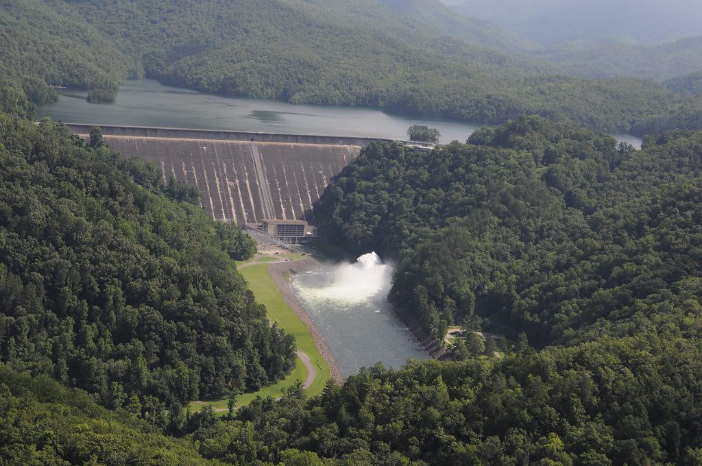
The curved concrete face of Fontana Dam between forested ridges, with the lake behind and spillway water churning below.Tennessee Valley Authority / CC BY 2.0 via Flickr
🏭Industrial

Fontana Dam

Part ofThe Great Smokies & Cherokee Country

TVA's wartime dam on the Little Tennessee, 480 feet tall, built in under three years for aluminum power at the cost of four drowned towns.

⏱
Duration
Forty-five minutes to an hour and a half.
🎟
Admission
Free.
📅
Best Season
Year round for the dam and overlooks; TVA's visitor center is open daily from May through October (NPS).

The Story

Alcoa began looking at the Little Tennessee around 1910 for power for its aluminum works in Tennessee, and by the mid-1930s it had bought land for a dam at Fontana. The project waited on the war. On August 14, 1941, TVA and Alcoa signed the Fontana Agreement, Congress funded the dam that December, and work began on January 1, 1942. By 1943 some 5,000 workers lived at Welch Cove, a camp built for them south of the dam and later kept as Fontana Village. The gates closed on November 11, 1944, and the first generators came on in January 1945 for wartime aluminum.

The lake took 68,292 acres. About 1,311 families and 1,047 graves were moved, with more than 60 miles of road, and the towns of Fontana, Bushnell, Forney and Judson went under the water. Fontana, a lumber and copper-mining town at the mouth of Eagle Creek, gave the dam its name, from the Italian for fountain. More than 40,000 acres of the north shore went to the Great Smoky Mountains National Park.

At 480 feet Fontana is the tallest dam in the eastern United States, its design largely the work of TVA chief architect Roland Wank, and it was listed on the National Register in 2017. Cracks that appeared in 1949 and again in the 1970s are still held in check by cutting relief slots every few years. The Appalachian Trail crosses the top before climbing into the Smokies, and TVA's visitor center stands just off NC 28 near the Tennessee line.

Visitor Info

⏱
Time Needed
Forty-five minutes to an hour and a half.
🎟
Admission
Free.
📅
Best Season
Year round for the dam and overlooks; TVA's visitor center is open daily from May through October (NPS).
🛣️
Highway
NC 28

On the Map

Nearby

The closest stops worth working into your route

natural9.6 mi away
Joyce Kilmer Memorial Forest
3,800 acres of uncut cove hardwood forest near Robbinsville, set aside in 1936 as a memorial to the poet of Trees, with poplars over 400 years old.
historical11 mi away
Cades Cove
A Smokies valley ringed by mountains, once the Cherokee hunting ground of Tsiyahi and later a farming community of 685 people, kept by the park after its families were bought out.
historical15 mi away
Lakeview Drive (the Road to Nowhere)
The park road promised in 1943 to replace a highway drowned by Fontana Lake, stopped at a tunnel in 1971 and settled for cash in 2010.
natural15 mi away
Cherohala Skyway
The 43-mile high road from Robbinsville to Tellico Plains, finished in 1996, climbing past 5,400 feet through the Nantahala and Cherokee national forests.
natural24 mi away
Newfound Gap
The lowest drivable pass through the Smokies, at 5,046 feet on the Tennessee and North Carolina line, where Roosevelt dedicated the park in 1940 and Kuwohi's Cherokee name was restored in 2024.
cultural25 mi away
Sequoyah Birthplace Museum
The Eastern Band of Cherokee Indians' museum on Tellico Lake, near the town where Sequoyah was born, telling how he built the Cherokee syllabary and what the Tellico Dam drowned.

Historical markers nearby

Roadside plaques and monuments within a short detour

Marker13 mi away
Chilhowee
Tallassee, Tennessee
Marker16 mi away
The Little River Lumber Company
Townsend, Tennessee
Marker16 mi away
Tuckaleechee Villages
Townsend, Tennessee
Marker16 mi away
John Mitchel
Townsend, Tennessee
Marker18 mi away
Tenasee Cherokee Village
Vonore, Tennessee
Marker19 mi away
Tellico Blockhouse
Vonore, Tennessee