Home / Georgia / Savannah & the Golden Isles / Cumberland Island National Seashore
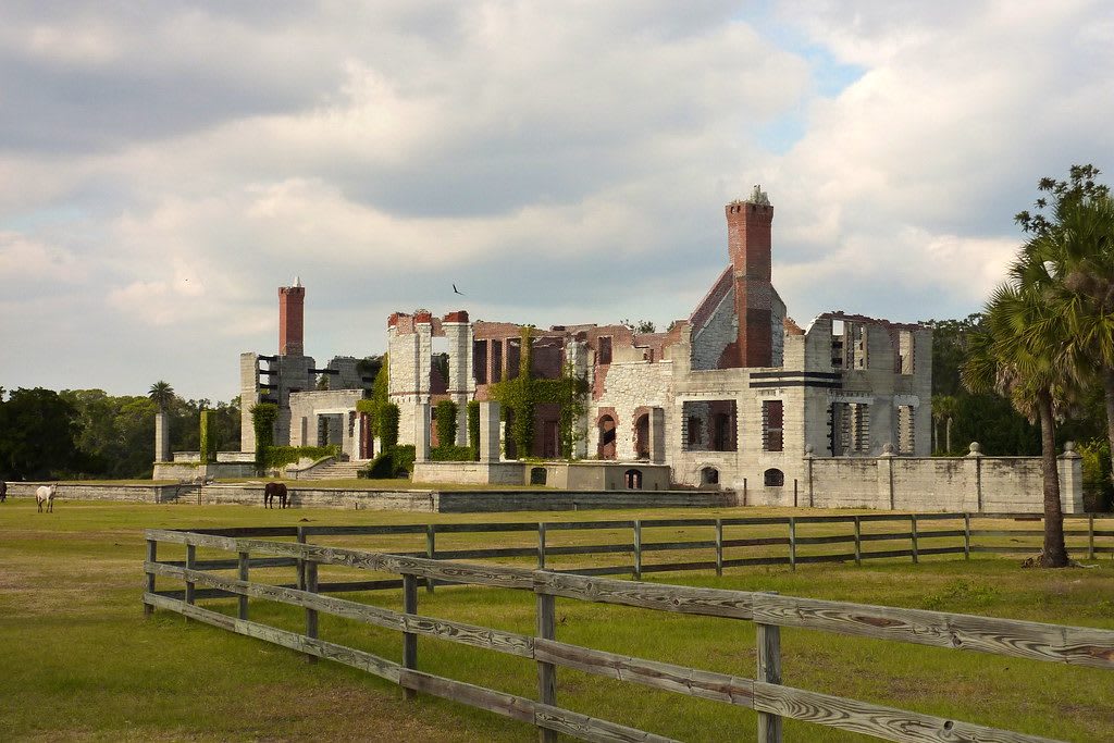
The roofless masonry ruins of Dungeness on Cumberland Island behind a wooden rail fence and open lawn.Mike Finn (muffinn) / CC BY 2.0 via Flickr
🌲Natural

Cumberland Island National Seashore

Part ofSavannah & the Golden Isles

Georgia's largest and southernmost barrier island, reached by passenger ferry from St. Marys: maritime forest, 18 miles of beach and the ruins of Dungeness.

⏱
Duration
A full day; camping is allowed by permit.
🎟
Admission
$15 per person 16 and older, valid seven days; cashless; the concession ferry is a separate fare (NPS, 2026).
📅
Best Season
Year round; spring and fall are best for hiking, and summer brings heat, insects and sea turtle nesting.

The Story

Timucuan people came to Cumberland for thousands of years to gather shellfish, and in the 1500s the Spanish, who called the island San Pedro Mocama, built a Catholic mission and a large fort here. English land grants began in 1765, and by 1860 more than 500 enslaved people lived on the island's fifteen plantations and farms. In 1815 the British flag flew at Dungeness for eight weeks, enslaved people came in on the promise of British emancipation, and the Royal Navy carried them, among some 1,400 taken from the coast in that war, to Bermuda, Nova Scotia and Trinidad.

Dungeness began as a five-story tabby mansion built in 1802 by the heirs of General Nathanael Greene. It burned in 1866, and the ruins standing now are of a second house built on the site in 1884. After the Civil War the island fell within the coastal strip set aside for freedpeople, and a small settlement grew on the north end; the Baptist church its descendants built still stands there. The Carnegie family, who bought land in 1881, held much of the island into the 1960s and worked with the National Park Foundation to bring it into public hands, and Congress created the seashore in 1972.

No cars cross. A passenger ferry leaves from the mainland visitor center in St. Marys, reservations are recommended, and every passenger checks in an hour before departure. The island has more than 50 miles of trails and roads and 18 miles of beach, and nothing to buy, so bring food and water and carry out your trash.

Visitor Info

⏱
Time Needed
A full day; camping is allowed by permit.
🎟
Admission
$15 per person 16 and older, valid seven days; cashless; the concession ferry is a separate fare (NPS, 2026).
📅
Best Season
Year round; spring and fall are best for hiking, and summer brings heat, insects and sea turtle nesting.
🛣️
Highway
GA 40

On the Map

Nearby

The closest stops worth working into your route

historical25 mi away
Jekyll Island Historic District
The Gilded Age club island where the Wanderer landed 409 captive Africans in 1858 and St. Andrews Beach was Georgia's only beach open to Black visitors.
roadside28 mi away
Folkston Funnel Railfan Platform
A covered train-watching platform in downtown Folkston where the CSX main line funnels nearly all Florida rail traffic, with dozens of trains a day and the Auto Train.
natural35 mi away
Okefenokee National Wildlife Refuge: Suwannee Canal Recreation Area
The refuge's main east entrance near Folkston: the 1891 drainage canal, the Chesser Island homestead, a boardwalk and tower, and the roads a Black CCC company built.
historical41 mi away
Hofwyl-Broadfield Plantation State Historic Site
A rice plantation on the Altamaha where 357 people were enslaved, later a family dairy, with the old rice fields still visible from the marsh trail.
historical44 mi away
Butler Island Plantation
The rice plantation south of Darien where Fanny Kemble kept her journal, and whose enslaved people were sold in 1859 in the Weeping Time.
historical45 mi away
Fort King George State Historic Site
A rebuilt 1721 cypress blockhouse at the mouth of the Altamaha, Britain's southernmost outpost in North America, in Guale country beside Darien.

Historical markers nearby

Roadside plaques and monuments within a short detour

Marker0.4 mi away
City of St. Marys
St. Marys
Marker18 mi away
Floyds' Fairfield and Bellview Plantations
Colesburg
Marker20 mi away
Camden County
Woodbine
Marker22 mi away
Treaty of Coleraine
Folkston
Marker24 mi away
M.E. Thompson and the Purchase of Jekyll
Jekyll Island
Marker25 mi away
Jekyll Island Club Wharf
Jekyll Island