Home / Alabama / Tuskegee & East Alabama / Chewacla State Park
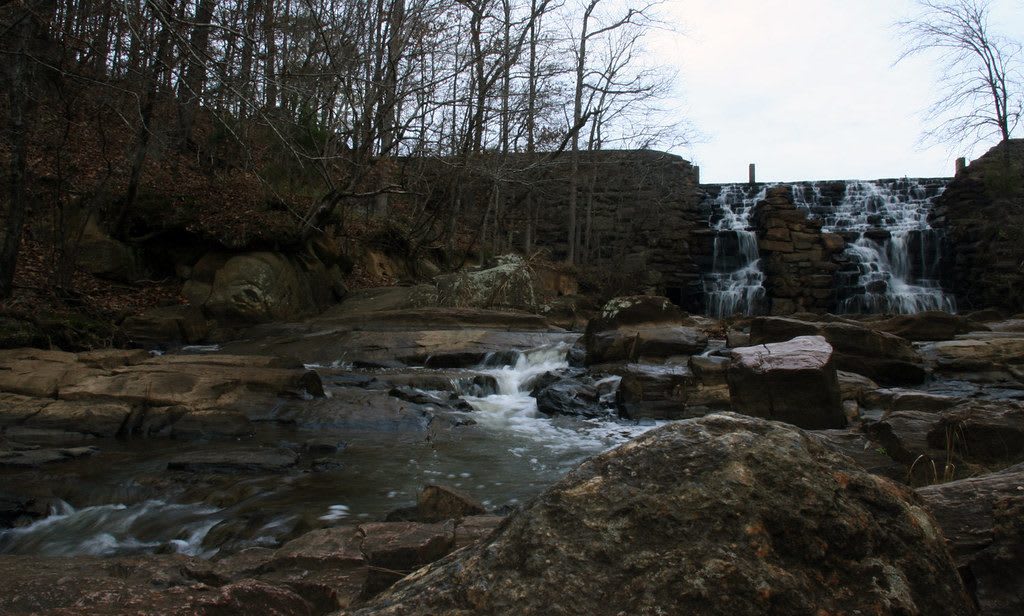
Water spilling over the stone dam at Chewacla State Park and down a rocky creek bed in winter woods.atlnature / CC BY 2.0 via Flickr
🌲Natural

Chewacla State Park

Part ofTuskegee & East Alabama

A 696-acre Civilian Conservation Corps park on Auburn's south edge, where a 1930s stone dam spills over as Chewacla Falls below a 26-acre lake.

⏱
Duration
Two hours to a full day.
🎟
Admission
Day-use fee charged by Alabama State Parks.
📅
Best Season
Spring for mountain laurel and high water at the falls; fall, outside Auburn home-game weekends, when the campground fills.

The Story

Three creeks run through this pocket of rocky hills south of Auburn, Chewacla, Moore's Mill and Town Creek, and people have come to swim in them for well over a century. A sawmill worked on Chewacla Creek from the early 1840s into the 1900s; W. W. Wright owned it from 1873, and the deep pool below Wright's Mill was the local swimming hole long before there was a park.

In 1935 the federal government bought the land and put a Civilian Conservation Corps camp on it. The young men of the CCC built six stone cottages, an arched masonry bridge, two miles of foot trails, roads, a bathhouse and a concrete-and-stone dam across Chewacla Creek that made the 26-acre lake. Alabama took the site over and opened it as Chewacla State Park in 1939. The cottages still stand, renovated, with their stone fireplaces, and they are rented year round.

The water that spills over the CCC dam drops 34 feet as Chewacla Falls, the best walk in the park, at the end of the Mountain Laurel Trail. The lake has a swimming beach and allows canoes and kayaks launched by hand, with no boat ramp. Mountain bikers have their own network of trails and a skills area near the entrance, and the creeks hold bass and bream. On Auburn football weekends the campground fills, so a weekday visit is quieter.

Visitor Info

⏱
Time Needed
Two hours to a full day.
🎟
Admission
Day-use fee charged by Alabama State Parks.
📅
Best Season
Spring for mountain laurel and high water at the falls; fall, outside Auburn home-game weekends, when the campground fills.
🛣️
Highway
Off I-85 on Auburn's south side

On the Map

Nearby

The closest stops worth working into your route

cultural3.8 mi away
Toomer's Corner
The corner of Magnolia Avenue and College Street where Auburn's campus meets its downtown, home of Toomer's Drugs since 1896 and of the oaks fans roll in toilet paper after a win.
historical8.1 mi away
Pioneer Park and Lee County Historical Society Museum
A railroad-era trade building and a village of old buildings in Loachapoka, the Creek town Lucv-Pokv, which militia destroyed in 1836.
natural11 mi away
Tuskegee National Forest
The nation's smallest national forest, replanted on worn-out Macon County cotton land by Tuskegee Institute and New Deal crews in the 1930s, with the Bartram Trail through it.
historical14 mi away
Tuskegee Airmen National Historic Site
Moton Field, the Tuskegee Institute airfield where every Black military pilot of World War II began flight training, now a National Park Service site with its hangars and control tower.
historical15 mi away
Tuskegee History Center
The museum Fred Gray and study survivor Herman Shaw founded in 1997 to remember the men of the Public Health Service syphilis study, and Macon County's welcome center.
historical16 mi away
Tuskegee Institute National Historic Site
The Tuskegee University campus that Booker T. Washington's students built by hand, with his house, The Oaks, and the George Washington Carver Museum kept by the National Park Service.

Historical markers nearby

Roadside plaques and monuments within a short detour

Marker3 mi away
The Old Rotation
Auburn
Marker3.6 mi away
Desegregation at Auburn
Auburn
Marker11 mi away
Birthplace of Zora Neale Hurston
Notasulga
Marker15 mi away
Samuel "Sammy" Leamon Younge, Jr.
Tuskegee
Marker15 mi away
Macon County Legal Milestone
Tuskegee
Marker16 mi away
Uchee Chapel Methodist Church
Hatchechubbee