On the sixth of August, 1904, wagonloads of people drove out onto a sun-hammered bench above the Virgin River to watch water arrive in a town that did not exist.
There were no houses on the Hurricane Bench that morning. No streets, no store, no church — nothing but two thousand acres of dry ground, the long red wall of the Hurricane Cliffs, and a crowd gathered at the mouth of a hand-dug ditch. When the water finally came, silted and alive and eleven years in the making, it poured out onto land that nobody lived on, and the crowd celebrated anyway, because everyone standing there understood the arithmetic. The houses could come later. The hard part was done.
Most towns in Utah were settled first and watered second: a company of families arrived, staked out lots, and then dug the ditches that would keep them alive. Hurricane ran the order in reverse. The ditch came first — eleven years of it — and the town followed only after the water proved it could be done. Drive through on Highway 9 today, racing toward Zion National Park with everyone else, and you are crossing a town whose founding document is not a charter or a plat map but a canal hanging off the wall of a gorge.
The problem the canal solved was upstream. The villages along the upper Virgin had spent four decades learning what the river did to fields planted within its reach — flash floods that arrived as walls of red mud, chewing away ditches, orchards, and whole farms in an afternoon. Some of those villages, like Grafton, eventually lost the argument altogether. And all the while the Hurricane Bench sat just downstream: two thousand acres of good flat land that the river could not touch, which was precisely the problem, because no water could touch it either. The bench already had its name by then. In 1863, a whirlwind tore the top off Erastus Snow's buggy on the descent of the nearby cliffs — "Well, that was a hurricane," he is supposed to have said — and the name attached itself to the fault, then the bench, and eventually the town. What the bench did not have was a single drop of water, and as early as 1865 surveyors had looked at the gorge upstream and pronounced a canal impossible.
In the fall of 1893, two men from the upriver towns — James Jepson and John Steele — mapped a route anyway. The Hurricane Canal Company they organized had no money and no engineers, so it paid its workers in the only currency it had: shares in the company and the promise of twenty acres of bench land once the water arrived. The men were farmers with farms to run, which meant the digging happened in the off-season, roughly November to May, year after year. They worked with picks, shovels, dynamite, and homemade wheelbarrows, boarding in camps in the gorge through the winter and going home to plant in the spring.
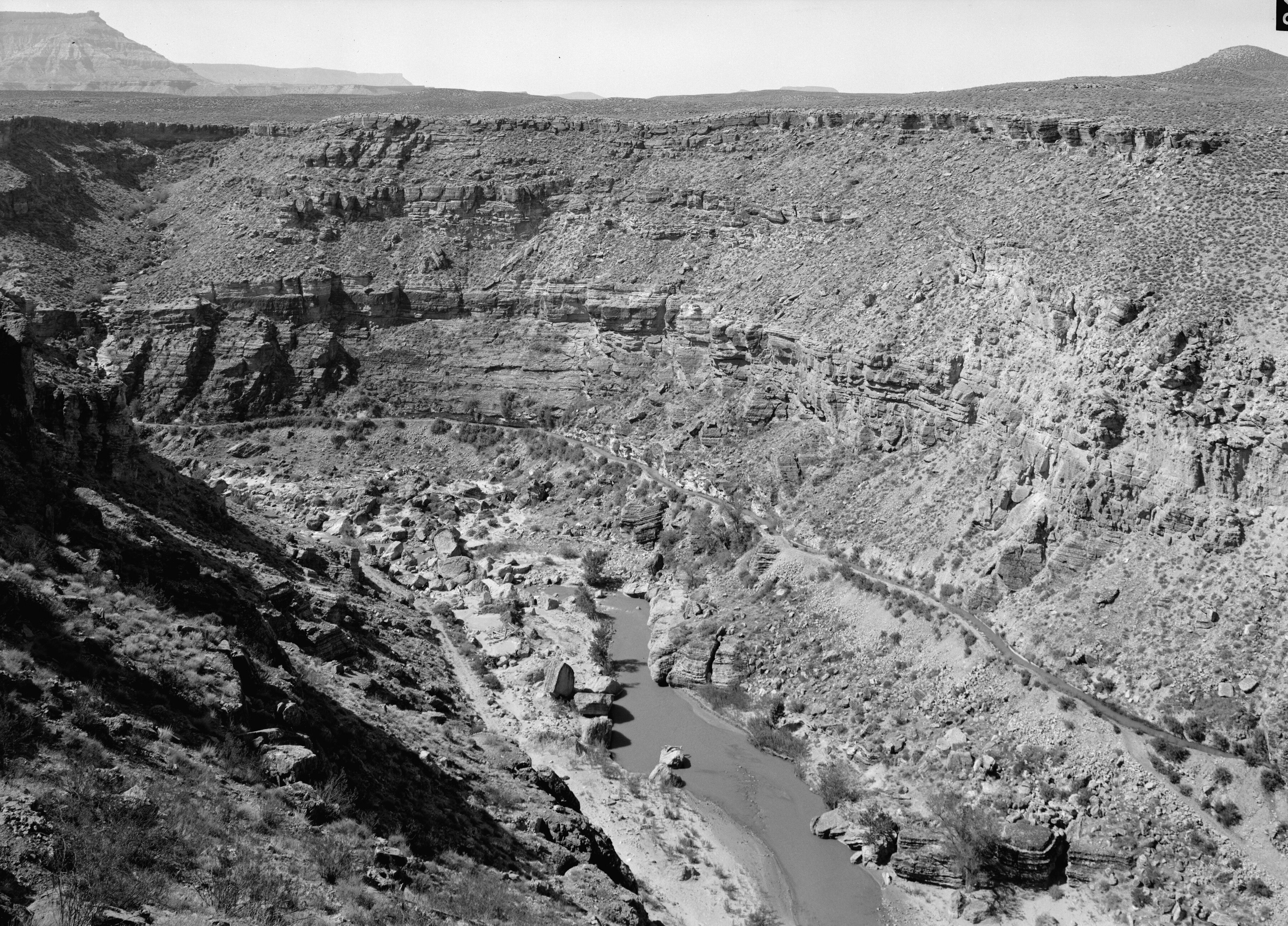
The route they had drawn was the kind of thing engineers refuse for a living. To get water high enough to reach the bench, the canal had to begin at a diversion dam seven and a half miles up the Virgin River gorge, then cling to the canyon wall on a blasted shelf about twelve feet wide — the channel itself eight feet across and four deep — through twelve tunnels cut in solid rock and across six wooden flumes on trestlework, before swinging south along the Hurricane Cliffs and out onto the bench. The river fought back the whole way. The first diversion dam washed out. So did the second. The third, reinforced with concrete and boulders, held.
What nearly killed the canal was not the rock but the years. As the work dragged into its second decade, discouraged shareholders drifted away, the workforce thinned, and the company ran out of money almost entirely. Jepson traveled to Salt Lake City to ask the LDS church to put money into the project, and Joseph F. Smith and the Twelve agreed to invest five thousand dollars in the company — enough to carry the work to the finish. Two years later, the water came down off the cliffs and onto the bench, and the wagonloads of neighbors came out to watch.
Then came the strangest interval in the whole story: the two years when Hurricane was a fully irrigated town with no one in it. The ditches ran, the shares were divided, the twenty-acre promises came due — and the first family, the Hintons, did not move onto the bench until 1906. From there the reversal completed itself with remarkable speed. Eleven families in 1906 became more than a hundred — some eight hundred people — by 1917, with orchards and field crops filling out the acreage the canal commanded. The town the ditch had promised was simply filled in, like water finding its level.
The canal did its work for eighty years. It was still carrying water in 1977 when it was listed on the National Register of Historic Places — a working piece of infrastructure decorated as a historic monument — and it was not retired until 1985, when a new pipeline began diverting the Virgin to fill Quail Creek Reservoir, with pressurized irrigation finishing the job by 1990. Two markers on Highway 9 keep the short version: the Daughters of Utah Pioneers raised theirs in 1937, when men who had swung picks in the gorge were still alive to read it, and the Sons of Utah Pioneers added theirs in 1987, just as the water was leaving the ditch for good.
But the markers are the small monument. The larger one is split in two. Half of it hangs in the gorge east of town, where a trail now follows the dry canal bed from the east end of 200 North — past a monument standing on the spot where the water first reached the bench — along the same twelve-foot shelf the builders blasted, through eleven of the twelve tunnels they cut by hand. The other half is the town itself: every lawn, orchard, and street of it sitting on ground that surveyors once wrote off as unwaterable. Hurricane is the rare place where you can hike the founding document. It is a ditch, and it came first.