Home / Kentucky / Bardstown, Bourbon & Lincoln Country / Rough River Dam State Resort Park
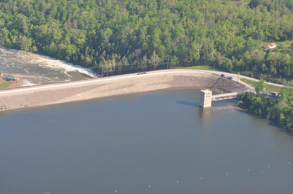
Aerial view of the earthen Rough River Dam, its intake tower and the lake against wooded hills.U.S. Army Corps of Engineers, Louisville District / CC BY 2.0 via Flickr
🏕️Recreational

Rough River Dam State Resort Park

Part ofBardstown, Bourbon & Lincoln Country

The resort park at the Corps of Engineers dam on the Rough River, with a lakeside lodge, a fly-in campground and a 39-mile lake reaching into three counties.

⏱
Duration
Half a day to a weekend.
🎟
Admission
Free to enter; lodge, cottages, marina rentals and the air camp are paid (Kentucky State Parks, 2026).
📅
Best Season
Spring to fall for the water; the lodge, cottages and launching ramp stay open year round on a reduced winter schedule.

The Story

The Rough River runs west to the Green. The U.S. Army Corps of Engineers began a dam here in 1955 and finished it in 1961, an earthen wall 1,590 feet across and 135 feet high, 89 miles above the river's mouth. Behind it the lake fills a Y-shaped valley 39 miles long across Breckinridge, Grayson and Hardin counties, about 5,100 acres in summer with 220 miles of shore. In winter the pool drops to about 2,180 acres.

The state built its resort park beside the dam: a lodge with 40 rooms facing the water, a restaurant, cottages, a marina, a pool and a short nature trail. The Lake Ridge Trail runs about a mile along the shore between the lodge, the marina and the cottages, and it is the place to look for bald eagles. A paved, lighted 3,200-foot airstrip lets pilots land and pitch a tent beside their planes at the air camp.

Anglers come for largemouth, white and spotted bass, crappie and catfish, with the best water up the two forks where the lake narrows. The dam itself has been under rehabilitation, and the park's history exhibit was created with the Corps and the Kentucky Heritage Council as part of that work, to tell what the valley was before the lake.

Visitor Info

⏱
Time Needed
Half a day to a weekend.
🎟
Admission
Free to enter; lodge, cottages, marina rentals and the air camp are paid (Kentucky State Parks, 2026).
📅
Best Season
Spring to fall for the water; the lodge, cottages and launching ramp stay open year round on a reduced winter schedule.
🛣️
Highway
KY 79

On the Map

Nearby

The closest stops worth working into your route

cultural17 mi away
Bill Monroe Museum and the Rosine Barn
Rosine's museum of Bill Monroe's own belongings, the Friday-night barn jamboree next door, and the Rosine Cemetery where he and his Uncle Pen are buried.
historical19 mi away
Bill Monroe Homeplace on Jerusalem Ridge
The restored farmhouse on Jerusalem Ridge above Rosine where Bill Monroe was born in 1911 and learned music from his mother and his Uncle Pen.
historical35 mi away
General George Patton Museum of Leadership
The Army's museum at Fort Knox, begun with the enemy vehicles Patton's Third Army shipped home in World War II, holding the largest collection of his personal belongings.
historical35 mi away
John Prine Memorial Park at Rochester Dam
A Green River county park at Rochester Dam, renamed in 2022 for John Prine, whose song Paradise mourned the Muhlenberg town that coal and TVA took away.
cultural35 mi away
Bluegrass Music Hall of Fame & Museum
Owensboro's riverfront museum of bluegrass, with the IBMA Hall of Fame, a picking parlor, Uncle Pen Vandiver's fiddle and a 450-seat theater.
historical35 mi away
Smothers Park and the Owensboro Riverfront
Owensboro's rebuilt Ohio River park, named for the settler of the Yellow Banks, in a downtown that held the country's last public execution in 1936.

Historical markers nearby

Roadside plaques and monuments within a short detour

Marker0.3 mi away
Revolutionary War Soldier
Falls of Rough
Marker11 mi away
Shelter for Lincolns
Hardinsburg
Marker12 mi away
County Named, 1799
Hardinsburg
Marker12 mi away
St. Romuald Church
Hardinsburg
Marker15 mi away
County Named, 1810
Leitchfield
Marker15 mi away
Jack Thomas House
Leitchfield