Home / South Carolina / Greenville & the Upstate Mountains / Oconee Station State Historic Site
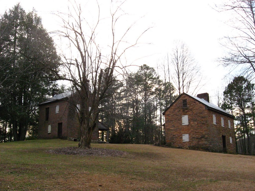
A two-story brick house and a stone blockhouse with a metal roof stand on a grassy slope among bare winter trees.Matthew T. Bradley / CC BY-SA 2.0 via Flickr
🏛️Historical

Oconee Station State Historic Site

Part ofGreenville & the Upstate Mountains
On this driveThe Cherokee Foothills Scenic Highway: Cowpens, Caesars Head, Table Rock, Walhalla and the Chattooga

A 1792 militia blockhouse and William Richards's 1805 trading-post house on what was South Carolina's western edge, with a trail to Station Cove Falls.

⏱
Duration
One to two hours with the falls walk.
🎟
Admission
Free; donations welcome (South Carolina State Parks, 2026).
📅
Best Season
Year round; spring for wildflowers along the falls trail. Grounds open daily 9 a.m. to 5 p.m. (South Carolina State Parks, 2026).

The Story

In the 1790s this hillside sat on South Carolina's western frontier. About 1792 the state militia built a stone blockhouse here as an outpost against Cherokee and Creek raids, and kept men at it until about 1799. It is the only piece left of the fort called Oconee Station, a plain building of fieldstone that has outlasted everything else on the post.

William Richards, an Irish immigrant, later kept a trading post here, a place where Cherokee people and white settlers came to trade goods. In 1805 he built the house that stands beside the blockhouse, and he lived in it until his death in 1809; the blockhouse became his kitchen. The house stayed a home into the 1960s and a summer place into the 1970s, and the state bought the property in 1976. Both buildings are on the National Register.

Walk up the hill from the lot, where waysides tell the story of each building; when the park interpreter is on hand, the doors open for a look inside. Below, a 1.5-mile nature trail circles a fishing pond and joins a Forest Service trail that ends at Station Cove Falls, a cascade in a cove of the Sumter National Forest. Spring brings an abundance of wildflowers to that walk.

Visitor Info

⏱
Time Needed
One to two hours with the falls walk.
🎟
Admission
Free; donations welcome (South Carolina State Parks, 2026).
📅
Best Season
Year round; spring for wildflowers along the falls trail. Grounds open daily 9 a.m. to 5 p.m. (South Carolina State Parks, 2026).
🛣️
Highway
SC 11

On the Map

Nearby

The closest stops worth working into your route

industrial3.9 mi away
Stumphouse Tunnel Park
The unfinished 1850s railroad tunnel Irish laborers drove into Stumphouse Mountain to link Charleston with the Midwest, beside Issaqueena Falls.
cultural5.7 mi away
Museum of the Cherokee in South Carolina
A small Walhalla museum of the Cherokee Lower Towns, Keowee, Seneca, Jocassee, Tamassee and the rest, built from what came out of this county's ground.
natural10 mi away
Devils Fork State Park
The only public way onto Lake Jocassee, a clear, cold reservoir over the Jocassee valley, where Oconee bells bloom along the trail each March.
historical12 mi away
Keowee-Toxaway State Park
A foothills park on Lake Keowee, whose water covers the Cherokee town of Keowee and the site of Fort Prince George.
natural13 mi away
Whitewater Falls
Upper Whitewater Falls, a 411-foot plunge off the Blue Ridge Escarpment just north of the South Carolina line in the Nantahala National Forest.
natural13 mi away
Chattooga Wild and Scenic River
The free-flowing river on the Georgia line, designated Wild and Scenic in 1974, with a river-access lot at the US 76 bridge.

Historical markers nearby

Roadside plaques and monuments within a short detour

Marker4.1 mi away
Tamassee DAR School
Tamassee
Marker5.5 mi away
The Cherokee Path
Salem vicinity
Marker5.6 mi away
St. John's Lutheran Church
Walhalla
Marker5.6 mi away
The English School
Walhalla
Marker5.7 mi away
The Lynching of Allen Green
Walhalla
Marker13 mi away
Seneca
Seneca