Home / Kentucky / Lake Cumberland & the Daniel Boone Country / Lake Cumberland State Resort Park
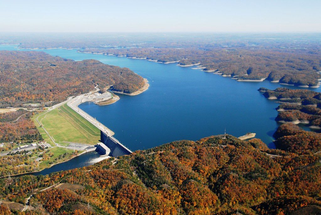
An aerial view of Wolf Creek Dam and Lake Cumberland in autumn, the long earthen and concrete dam holding back blue water between wooded ridges.U.S. Army Corps of Engineers Nashville District / CC BY-SA 2.0 via Flickr
🏕️Recreational

Lake Cumberland State Resort Park

Part ofLake Cumberland & the Daniel Boone Country

A state park on the north shore of Lake Cumberland near Jamestown, on the reservoir Wolf Creek Dam made of the Cumberland River in the 1950s.

⏱
Duration
Half a day to several days.
🎟
Admission
No entrance fee; lodging, camping, marina rentals and some activities are charged.
📅
Best Season
Late spring through early fall for the water; spring and fall for the trails.

The Story

Lake Cumberland is the Cumberland River held back. Congress took up a private power proposal in the Flood Control Act of 1938, the Corps of Engineers moved the site downstream to make a far bigger reservoir, and after delays through the Second World War Wolf Creek Dam opened in 1951, a few miles southwest of this park. Congress named the lake in 1952. At its normal summer level it covers some 50,000 acres and runs about 101 miles back up the river and its forks, with more than 1,200 miles of shoreline.

The water took towns with it. Burnside, the old steamboat and lumber town where the Big South Fork meets the Cumberland, was moved whole to higher ground in the early 1950s, and Creelsboro below the dam was hurt as well. The dam itself had a flaw: it stands on karst limestone, and in 1968 seepage and sinkholes appeared at its foot. Grouting and a concrete wall in the 1970s held it for a time, but in January 2007 the Corps rated it high risk and drew the lake down about 40 feet. A new barrier wall inside the dam was finished in 2013, and the lake returned to normal in 2014.

The park, about four miles south of Jamestown, covers more than 3,000 acres of the shore. It has Lure Lodge, a campground, trails and a marina, and it makes a good base for seeing how big the lake is.

Visitor Info

⏱
Time Needed
Half a day to several days.
🎟
Admission
No entrance fee; lodging, camping, marina rentals and some activities are charged.
📅
Best Season
Late spring through early fall for the water; spring and fall for the trails.
🛣️
Highway
US-127

On the Map

Nearby

The closest stops worth working into your route

historical14 mi away
Mill Springs Mill
An 1877 gristmill with a 40-foot overshot wheel on the south shore of Lake Cumberland in Wayne County, beside the Confederate ferry landing of the Mill Springs campaign.
historical19 mi away
Mill Springs Battlefield National Monument
The January 1862 battlefield at Nancy, west of Somerset, where Union troops under George Thomas broke the eastern end of the Confederate line across Kentucky.
natural24 mi away
Dale Hollow Lake State Resort Park
A 3,400-acre state park on the Kentucky end of Dale Hollow Lake, a deep, clear Corps of Engineers reservoir on the Obey River that holds the world-record smallmouth bass.
historical25 mi away
Cordell Hull Birthplace and Museum State Park
A replica of the log cabin where the secretary of state and Nobel laureate was born in 1871, with a museum of his belongings, in Pickett County's hills.
historical27 mi away
Sgt. Alvin C. York State Historic Park
The Wolf River valley farm, gristmill and grave of Alvin York, the conscientious objector turned Medal of Honor soldier, now a National Historic Landmark district.
recreational29 mi away
Green River Lake State Park
The state park on the Corps of Engineers lake south of Campbellsville, with 28 miles of trails, winter eagles and the Tebbs Bend battlefield of 1863 just below the dam.

Historical markers nearby

Roadside plaques and monuments within a short detour

Marker3.9 mi away
Jamestown Skirmishes
Jamestown
Marker13 mi away
Forage Depot-Civil War
Marker15 mi away
West-Metcalfe House
Mill Springs
Marker16 mi away
Price's Meadow
Monticello
Marker17 mi away
County Named, 1835
Albany
Marker17 mi away
Civil War Terrorist
Albany