Home / Kentucky / Paducah & Land Between the Lakes / Kentucky Dam
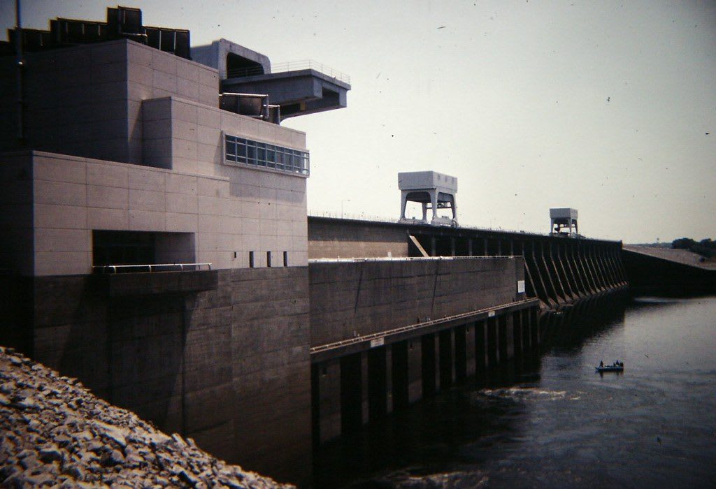
The concrete powerhouse of Kentucky Dam beside a long row of spillway piers and gantry cranes, with a small boat on the tailwater below.Gary Lee Todd / CC0 via Flickr
🏭Industrial

Kentucky Dam

Part ofPaducah & Land Between the Lakes

TVA's longest dam, closed in 1944 near the mouth of the Tennessee River, and the lake that moved 2,609 families and drowned Birmingham, Kentucky.

⏱
Duration
Thirty minutes to an hour.
🎟
Admission
Free to view from the public areas.
📅
Best Season
Year round.

The Story

Congress authorized Kentucky Dam in May 1938, and the Tennessee Valley Authority closed its gates on August 30, 1944, near the mouth of the Tennessee River; the first generator came online two weeks later, with the war still on. The dam runs 8,422 feet and rises 206 feet, more than half of it below water, the longest dam on the Tennessee and in the whole TVA system. Its lock, the first TVA designed, lifts towboats as much as 75 feet, and a lock twice as long is planned beside it.

The lake behind it is the largest TVA reservoir, with 2,064 miles of shoreline, and it came at a price paid by the valley. TVA bought 320,244 acres, relocated 2,609 families and 3,390 graves, and moved 365 miles of road. The Marshall County river town of Birmingham went under entirely, as did Johnsonville and Springville upstream in Tennessee. Twenty years later the same agency would clear the land between this lake and the Cumberland for a recreation area.

For decades US 62 and 641 and a railroad crossed the top of the dam. Since two new bridges opened downstream in late 2009, the road on the crest serves only local traffic to the powerhouse and visitor area. The best view is from below, where the concrete powerhouse and the long run of spillway gates face the tailwater, and small boats work the current. Kentucky Dam Village State Resort Park lies along the lake on the Gilbertsville side.

Visitor Info

⏱
Time Needed
Thirty minutes to an hour.
🎟
Admission
Free to view from the public areas.
📅
Best Season
Year round.
🛣️
Highway
US 62 / US 641

On the Map

Nearby

The closest stops worth working into your route

natural12 mi away
Clarks River National Wildlife Refuge
Bottomland hardwood swamp along the East Fork of the Clarks River near Benton, a refuge since 1997 for waterfowl and migrating songbirds.
cultural19 mi away
Paducah Floodwall Murals
The riverfront wall built after the 1937 flood, painted since 1996 with Paducah's history, at the meeting of the Tennessee and Ohio on land the Chickasaw ceded in 1818.
historical19 mi away
Hotel Metropolitan
Maggie Steed's 1908 hotel for Black travelers in Paducah's Upper Town, a Green Book and Chitlin' Circuit stop, now a museum.
cultural19 mi away
National Quilt Museum
Paducah's museum of contemporary quilts since 1991, with more than 700 quilts made after 1980, almost all by women.
natural20 mi away
Elk & Bison Prairie
A 700-acre restored grassland in Land Between the Lakes where elk and bison roam inside a fence, seen from a 3.5-mile paved loop.
historical20 mi away
Golden Pond Visitor Center
The hub of Land Between the Lakes, near the site of Golden Pond, a town TVA cleared in the 1960s with the farms and hamlets of Between the Rivers.

Historical markers nearby

Roadside plaques and monuments within a short detour

Marker1.9 mi away
Grand Rivers Furnace
Grand Rivers
Marker4.5 mi away
"Oak Hill"
Calvert City
Marker4.6 mi away
Andrew Jackson Smith
Marker6.1 mi away
Suwanee Furnace
Kuttawa
Marker11 mi away
Matthew Lyon Grave
Eddyville
Marker11 mi away
Civil War Base
Smithland