Home / North Carolina / Wilmington & the Cape Fear / Fort Fisher State Historic Site
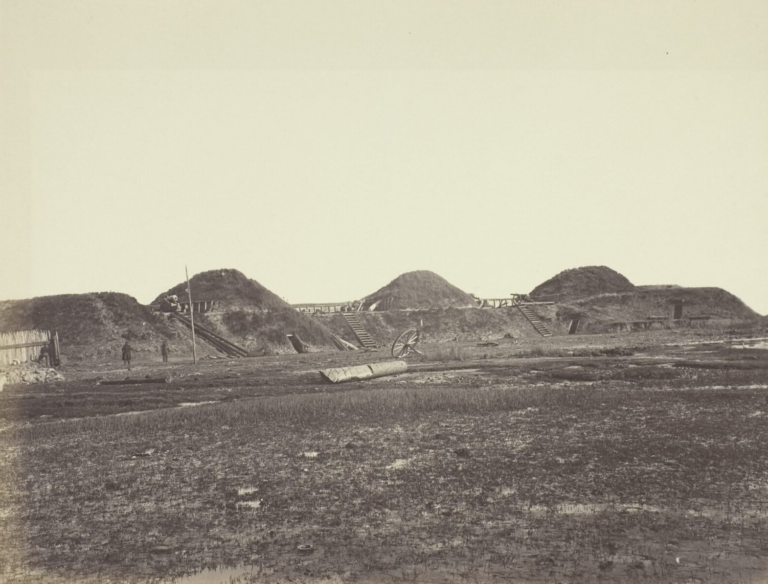
An 1865 photograph of the tall sand traverses of Fort Fisher's land face, with stairs, a gun carriage wheel and flat marsh in front.Timothy H. O'Sullivan, January 1865 / public domain via Art Institute of Chicago
🏛️Historical

Fort Fisher State Historic Site

Part ofWilmington & the Cape Fear

The surviving land face of the largest Confederate earthwork, built with Black labor and taken in January 1865 by an assault that included the 27th U.S. Colored Troops.

⏱
Duration
One and a half to two hours.
🎟
Admission
Grounds and visitor center free; guided tours $5 adults, $4 seniors 65+ and military, $1 children 3-17, plus tax (NC Historic Sites, 2026).
📅
Best Season
Year round; closed Sunday, Monday and state holidays (NC Historic Sites, 2026). Fall and spring are mildest on the open earthworks.

The Story

More than five hundred African Americans, enslaved and free, worked beside Confederate soldiers to build Fort Fisher, at times as many as a thousand men at once. Under Col. William Lamb, from July 1862 it grew from a few sand batteries into the largest earthwork fort in the South: a mile of sea face and a third of a mile of land face, 15 mounds 32 feet high with bombproofs and magazines inside, fronted by a nine-foot palisade. Its guns held the Union blockade off so that steamers from Bermuda, the Bahamas and Nova Scotia could run into Wilmington, trading cotton and tobacco for supplies for Lee's army.

A Union attack at Christmas 1864 failed. The fleet came back on January 12, 1865, and shelled the fort for two and a half days, and on January 15 more than 3,300 Union infantry, the 27th U.S. Colored Troops among them, assaulted the land face and took it after hours of hand-to-hand fighting. Within weeks Union forces held Wilmington, and the last major port open to the Confederacy was shut.

The ocean has taken most of the fort, and less than a tenth survives. About 180 yards of the land face stand on the river side of US 421, with the Seventh, Eighth and Ninth traverses rebuilt, an enterable bombproof, the center sallyport and a reconstructed 32-pounder at Shepherd's Battery, and a half-mile trail loops the remains under live oaks. A 20,000-square-foot visitor center opened in October 2024, with objects from sunken blockade runners, and the state's underwater archaeology headquarters shares the grounds.

Visitor Info

⏱
Time Needed
One and a half to two hours.
🎟
Admission
Grounds and visitor center free; guided tours $5 adults, $4 seniors 65+ and military, $1 children 3-17, plus tax (NC Historic Sites, 2026).
📅
Best Season
Year round; closed Sunday, Monday and state holidays (NC Historic Sites, 2026). Fall and spring are mildest on the open earthworks.
🛣️
Highway
US 421

On the Map

Nearby

The closest stops worth working into your route

historical5.1 mi away
Brunswick Town / Fort Anderson State Historic Site
The excavated foundations of a colonial Cape Fear port burned in 1776, St. Philip's church walls, and the sand walls of Confederate Fort Anderson on the same bluff.
historical8.2 mi away
Old Baldy Lighthouse
North Carolina's oldest standing lighthouse, an 1817 octagonal brick tower on Bald Head Island at the mouth of the Cape Fear, reached by ferry from Southport.
historical18 mi away
Gregory Congregational Church
The church of a freedpeople's school at Third and Nun streets, where Wilmington's Black students gathered in 1971 and the Wilmington Ten case began.
historical18 mi away
Bellamy Mansion Museum
A 1859-61 Market Street mansion built by enslaved and free Black craftsmen, with one of the best-preserved urban slave quarters in the country behind it.
historical19 mi away
1898 Memorial Park
Six bronze paddles on North Third Street for the Black Wilmingtonians killed on November 10, 1898, in the coup that overthrew the city's elected government.
natural23 mi away
Green Swamp Preserve
Nature Conservancy longleaf savannas in the Green Swamp, kept open by fire, with wild Venus flytraps, pitcher plants, sundews and orchids.

Historical markers nearby

Roadside plaques and monuments within a short detour

Marker0 mi away
W. H. C. Whiting
Kure Beach
Marker0.4 mi away
Modern Greece
Kure Beach
Marker2.6 mi away
Bromine Extraction
Kure Beach
Marker5.1 mi away
John LaPierre
Winnabow
Marker5.3 mi away
Stede Bonnet
Southport
Marker6.7 mi away
Robert Howe
Winnabow