Home / Georgia / The North Georgia Mountains / Amicalola Falls State Park
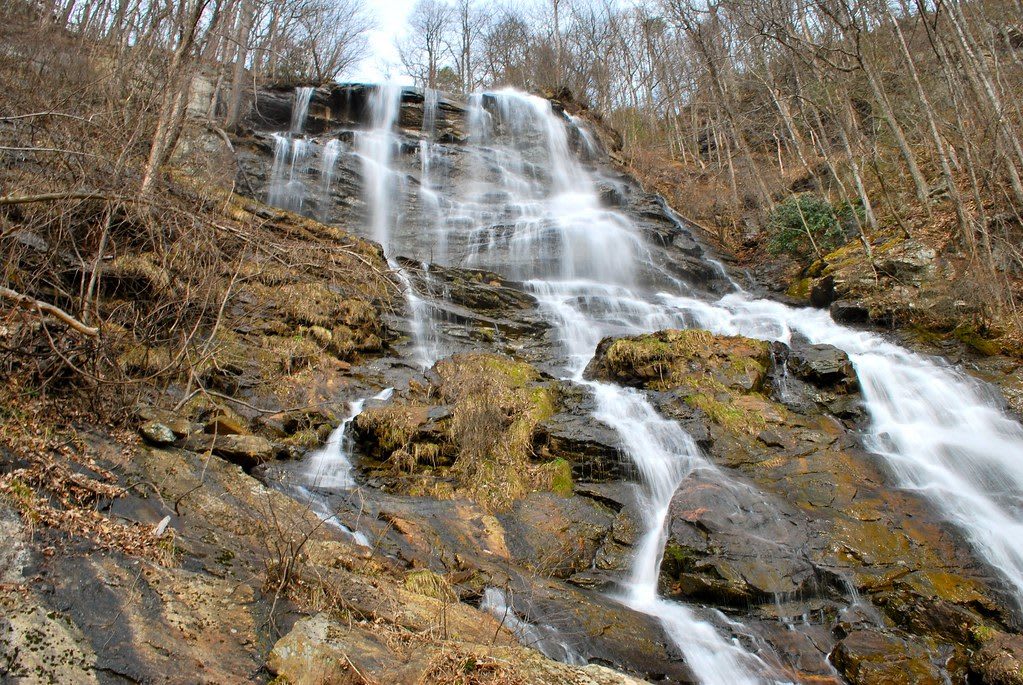
Amicalola Falls in winter, white water spreading over tiers of dark rock on a slope of bare trees.Ronnie / CC BY 2.0 via Flickr
🌲Natural

Amicalola Falls State Park

Part ofThe North Georgia Mountains

The tiered falls of Little Amicalola Creek in Dawson County, named in Cherokee, first written up by a Georgia Guard officer in 1832, and the start of the Approach Trail to Springer Mountain.

⏱
Duration
One to three hours; a full day for the Approach Trail to Springer Mountain.
🎟
Admission
Georgia State Parks ParkPass parking fee per vehicle; annual passes accepted (2026).
📅
Best Season
Year round. The falls run fullest after winter and spring rain; northbound Appalachian Trail hikers start here in largest numbers in early spring.

The Story

The name comes from Cherokee words for water and tumbling, and Cherokee towns stood along the Amicalola and the Etowah until state and federal troops forced the people out in the late 1830s. The first written account by a white Georgian came in 1832 from William Williamson, an officer of the Georgia Guard, the state force sent to hold the gold mines. Governor Wilson Lumpkin had sent him to gauge the Cherokee response to the Supreme Court's Worcester v. Georgia decision, and Williamson wrote back that he had found a waterfall perhaps the greatest in the world.

Little Amicalola Creek falls down Amicalola Mountain in tiered cascades over three-tenths of a mile. The park gives the height as 729 feet, but that figure runs from the top to the visitor center; measured to the plunge pool the drop is closer to 580 feet, and remote sensing puts it nearer 450. The park opened in 1940. A lake built above the falls in 1941 was drained in 1977, when inspectors ruled its dam unsafe after the Kelly Barnes Dam disaster at Toccoa.

The visitor center at the base, rebuilt in 2023, has a stone archway behind it where the eight-mile Approach Trail to Springer Mountain begins, the usual first steps for hikers bound for Maine; climbing the falls' several hundred stairs under a full pack is a rite of passage. Drivers can take the park road instead to a lot beside the upper viewing platform.

Visitor Info

⏱
Time Needed
One to three hours; a full day for the Approach Trail to Springer Mountain.
🎟
Admission
Georgia State Parks ParkPass parking fee per vehicle; annual passes accepted (2026).
📅
Best Season
Year round. The falls run fullest after winter and spring rain; northbound Appalachian Trail hikers start here in largest numbers in early spring.
🛣️
Highway
GA 52

On the Map

Nearby

The closest stops worth working into your route

historical15 mi away
Dahlonega Gold Museum State Historic Site
The 1836 Lumpkin County Courthouse on Dahlonega's square, telling the 1829 gold rush onto Cherokee land, the lotteries that followed and the branch mint that coined Georgia gold.
historical22 mi away
Blue Ridge Scenic Railway
Excursion trains from the 1905 Louisville and Nashville depot in Blue Ridge, running 13 miles beside the Toccoa River to McCaysville and Copperhill on the 1886 line.
historical22 mi away
Walasi-Yi Center at Neel Gap
The 1934-38 Civilian Conservation Corps stone inn at Neel Gap on US 129, where the Appalachian Trail passes through a breezeway between its two halves.
cultural24 mi away
Funk Heritage Center
Georgia's official Southeastern Indian interpretive center at Reinhardt University in Waleska, a certified Trail of Tears site in the old Cherokee Nation.
natural29 mi away
Fort Mountain State Park
A mountain park between Chatsworth and Ellijay named for an ancient stone wall on its peak, with a CCC fire tower, a lake and long views over the Cohutta country.
cultural32 mi away
Helen
The White County sawmill town on the Chattahoochee headwaters that its merchants rebuilt as a Bavarian village from 1968, after the timber and the railroad were gone.

Historical markers nearby

Roadside plaques and monuments within a short detour

Marker0 mi away
The Appalachian Trail
Dawsonville
Marker11 mi away
Old Federal Road
Jasper
Marker12 mi away
Pickens County
Jasper
Marker12 mi away
Old Federal Road
Jasper
Marker12 mi away
Georgians in the Union Army
Dawsonville
Marker12 mi away
Dawson County
Dawsonville