In the summer of 1933, on the edge of a 1,500-foot chasm in the high country above Boulder, Utah, a man tied a rope around his waist, climbed onto a bulldozer, and drove forward onto two pine logs laid across the gap. A handful of Civilian Conservation Corps workers stood on the cliff behind him, holding the other end of the rope. If the logs snapped, the rope might catch him before he and the bulldozer fell eight hundred feet to the floor of Death Hollow. It also might not. The CCC's calculation that summer was that some risks are worth taking when there is no other way to get a bulldozer to the far side of a canyon.
The logs held. The bulldozer reached the other side. And the construction of what would become known as Hell's Backbone Road — or, to the men building it, the Poison Road — could begin from both ends of the chasm simultaneously.
That was how Boulder began ending its isolation. Or tried to.
A petition to the President
By 1933, Boulder was the last town in the continental United States to receive its mail by mule. The pack trains came in from Escalante, thirty miles south, on a trail so steep and remote that no vehicle could traverse it. The town had been settled fifty years earlier, in 1889, and in the half-century since, no road had ever connected it to the outside world. The geography simply would not allow it. To reach Boulder, you crossed canyons, climbed mountains, descended slickrock, and arrived — if you arrived — on horseback or on foot or by mule.
The town wanted out of this arrangement. So did Escalante, whose economy depended in part on supplying Boulder. When Franklin Delano Roosevelt signed the Civilian Conservation Corps into law in March of 1933 — one of the first programs of the New Deal, designed to put unemployed young men to work on public lands — the citizens of Boulder and Escalante petitioned the President for a road. They had been waiting for fifty years. They wanted a road now.
What they got was the CCC's Blue Spring Ridge Camp, established on Escalante Mountain in the summer of 1933, with crews assigned to build the first vehicle road between the two towns. The choice of route was, by any reasonable measure, insane. The most direct line between Boulder and Escalante crossed terrain so vertical and exposed that no surveyor in his right mind would have proposed it. But the alternatives — routes through the canyons to the south — required more engineering than the CCC could deliver in a single season. So the crews picked the high line. They would go over the top.
The road they built
The route the CCC laid out climbed from Escalante up the back of Escalante Mountain, ran along the ridge at over 9,000 feet of elevation, crossed Death Hollow Canyon on a single bridge, traversed a narrow saddle of rock — the backbone itself — and descended through aspen and ponderosa forest into the Boulder valley. Thirty-eight miles total. The high point was roughly 9,200 feet. The drops, in places, were sheer thousand-foot falls into the wilderness of Box-Death Hollow on one side and the Sand Creek drainage on the other.
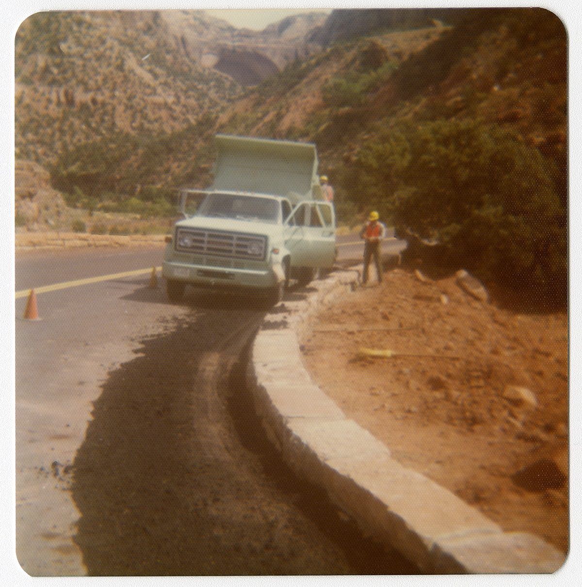
The men building it called it the Poison Road. The name was not editorial. It was descriptive. One false step on the wrong section meant a fall that no rope, no friend, no hospital could undo. The CCC was a young man's program — most of the crew were teenagers and young men in their early twenties, the demographic hit hardest by the Depression — and they worked the road with hand tools, mules, dynamite, and the bulldozer that had been winched and roped across the chasm at Death Hollow. There was no other heavy equipment available. There were no helicopters. There were no cell phones. If a man got hurt on the road, his fellow workers carried him out.
The bridge at Death Hollow was the centerpiece. The original 1933 structure was a wooden span, 109 feet long and 14 feet wide, crossing a gap with an 800-foot drop directly below and a 1,500-foot fall to the canyon floor on either side. It was, when it was built, one of the most exposed bridges in the American highway system. The CCC crews finished it the same summer they started it. By September of 1933, the bridge was open, the road was driveable, and for the first time in Boulder's history, a vehicle could be driven from Boulder to Escalante and back.
Boulder threw a party. Cars came up the new road from Escalante. The town that had been on mule mail since its founding was, suddenly, on the highway system.
And it wasn't enough
The road was a summer road. By late October, the high country was already getting snow. By December, the ridge at 9,000 feet was buried, and the road was closed. It would not open again until late spring. For five months of every year, Hell's Backbone might as well not have existed.
So Boulder went back to mules. Not all the time, and not for everyone — supply runs in winter could still be made by wagon through the lower canyons, slow and difficult but possible. But the U.S. mail, which required reliability above all else, continued to come by pack train through the winter months. The road that had been built to end Boulder's mule-mail era had ended it only for half the year. The other half, Boulder remained the last mule-mail town in America.
This was not the road's fault. It was the geography's. The route the CCC had picked was the only route they could finish in a single season, and the route that could be finished in a single season was, by definition, a high-country route. To build a road that worked year-round would mean a road that stayed low — a road through the canyons, around the mountains, taking the long way. That road would require more engineering, more dynamite, more time, and more money than the CCC's first effort. It would require, in effect, starting over.
In 1935, they did. A second CCC project began work on what was called the Lower Boulder Road — a route that would follow the canyons and slickrock to the south of Hell's Backbone, descending instead of climbing, taking a longer path through more manageable terrain. The project would take five years. The road would open in 1940. The road, eventually, would be paved, expanded, designated a scenic byway, and renamed: today it is Highway 12, and it is consistently ranked among the most beautiful drives in America. The CCC's second attempt at connecting Boulder is the highway that 750,000 visitors drive every year.
Boulder's first road, the Poison Road, became something else: a backup, a curiosity, a high-country alternative. It is still there. It is still open in summer. The original wooden bridge has been replaced — a steel and concrete span sits in its place — but the road still climbs the same ridge, crosses the same canyon, and arrives in Boulder by the same impossible route the CCC laid out in 1933.
Driving it now
Most people who travel through this corner of Utah do not know Hell's Backbone exists. Highway 12 is the route. It is paved, fast, safe, and stunning. The drive from Boulder to Escalante on Highway 12 takes under an hour. The drive on Hell's Backbone takes two to three hours, requires a high-clearance vehicle in marginal conditions, is closed entirely from late fall to late spring, and offers no services, no cell signal, and no margin for mechanical error.
For these reasons, it is empty. On a summer afternoon when Highway 12 is moving thousands of cars, Hell's Backbone might see ten vehicles. The road that two towns once petitioned the President for has become a road that almost no one takes.
What you find, if you take it, is the country the CCC found in 1933. The ridge runs along the spine of the high plateau between Box-Death Hollow Wilderness to the west and the Sand Creek drainage to the east. The forest is ponderosa pine and aspen at the high elevations, sage and juniper as the road descends toward Boulder. The bridge at Death Hollow — the modern replacement, not the original wooden span — is still 109 feet long and 14 feet wide, and the drop is still 1,500 feet. The view from the middle of the bridge, looking south, is into the Box-Death Hollow Wilderness, one of the least-visited wilderness areas in the United States. You can stand on the bridge and see, in any direction, no human structure other than the road you came in on.
It is silent. It is enormous. It is what the country looked like before there was a country.
What the road is for
There is a temptation, with a place like Hell's Backbone, to call it a failure. It did not, in the end, do what it was built to do. It did not connect Boulder to the outside world year-round. It did not end mule mail. The road that did those things came later, took five years, and is the one that gets the cars and the scenic-byway designation and the photographs.
But the framing is wrong. Hell's Backbone was not built to be sufficient. It was built to be first. The people of Boulder and Escalante did not petition Roosevelt for a perfect road. They petitioned for any road. The CCC did not pick the high-country route because it was the best route. They picked it because it was the route they could finish before winter. The thing being attempted was not the construction of a permanent transportation corridor. It was the construction of proof — proof that the corridor was possible, proof that Boulder could be reached, proof that fifty years of isolation could end if enough people decided to end it.
The proof took one summer. The actual ending of isolation took seven more years. Both efforts mattered. Neither would have happened without the other.
If you stand on Hell's Backbone Bridge today and look down into Death Hollow, you can see the country the CCC saw in 1933. You can see the route they did not take — the lower canyons that would eventually become Highway 12, easier ground, the road of the future. And you can see why they did not take it. The lower route was the right answer. It was also the wrong answer for the summer of 1933, when what Boulder needed was not the right answer but any answer, and the CCC's job was not to be correct but to begin.
They began with a bulldozer on two pine logs. They began with a rope around a man's waist. They began with the most dangerous bridge in the American highway system, built by teenagers, in a single summer, across a chasm that swallows the light.
The road they built is still there. So is the town it was built to reach. That is what the Poison Road was for.