A freight train crossing the Colorado River on a steel deck-truss railroad bridge at low sun, shot from high on the bank straight into the light. The locomotives and the string of boxcars and a single tank car catch the last of the sun along their flanks in hard gold, while the lattice piers and cross-bracing beneath the deck, the river and the whole near shore fall into silhouette; beyond, the far bank runs flat to a line of dark ranges under a pale sky. The frame carries the deep shadow and saturated colour of a colour transparency. Route 66 itself is not in the picture — the crossing here is the railroad's.
railfan 44 / public domain via Wikimedia Commons
Arizona · Region

Route 66 & the Colorado River

The Mother Road and the water border with California — the longest surviving stretch of Route 66 from Seligman through Kingman to Oatman, the Black Mountains switchbacks, and the Colorado River lakes from Lake Havasu down to Yuma.

6 places to explore

Arizona holds the longest surviving stretch of Route 66 in the country — some three hundred eighty miles of the Mother Road, including the single longest uninterrupted run of the original alignment left anywhere, the hundred and sixty miles from Seligman west through Kingman. That the road survived at all is one town's doing. When Interstate 40 bypassed Seligman in 1978 and left it for dead, a barber named Angel Delgadillo organized the businesses still hanging on, and in 1987 Arizona designated the stretch Historic Route 66. The nostalgia trade that followed — the neon, the burros, the Snow Cap Drive-In — grew straight out of that refusal to close. In 2026 the road turns a hundred, and this is where the country comes to drive it.

It saves its best for the western end. Past Kingman the old highway climbs into the Black Mountains on the Oatman road, a set of cliff-edge switchbacks over Sitgreaves Pass no interstate would ever tolerate, and drops into Oatman, a gold camp gone over to wild burros and staged gunfights in the street. The long eastern approach runs through the pine country of the Hualapai, whose land holds the western rim of the Grand Canyon.

Then the road meets the water. The Colorado is the region's western edge and its reason for being — the border with California and Nevada, dammed into a chain of desert lakes. Lake Havasu City imported the actual London Bridge, shipped stone by numbered stone and rebuilt over a dredged channel in 1971. Downriver, Yuma held the crossing everyone bound for California once had to make, and later the territorial prison that gave the town its teeth. This is Yuman and O'odham country too — the Mojave, who call themselves Pipa Aha Macav, the people by the river; the Quechan; the Cocopah. The Mother Road gets the postcards. The river was here first, and it decided everything.

What to See in Route 66 & the Colorado River

6 places across the region, grouped by what they are.

Geology & Rock Formations
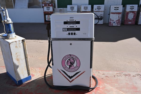
A restored Tokheim gasoline pump standing on a concrete forecourt at Grand Canyon Caverns, filling the frame — white with a chrome band, its dial faces lettered THIS SALE and GALLONS, a black hose looped to the ground, and a Mohawk Gasoline brand disc on its lower door carrying a mid-century Native American head device. A rusted white service cabinet stands at the left, and a row of seven more vintage pumps in white, red and cream is ranged along a building behind, low sun throwing their shadows across the apron. The cavern itself, and the 210-foot descent to it, are not in the frame.

Grand Canyon Caverns

Peach Springs

The largest dry cavern in the country, 210 feet under Route 66 — a Cold War fallout shelter, the deepest hotel room in America, and a Hualapai burial place the tourists once mistook for a sideshow.

View details →

Towns & Gateways

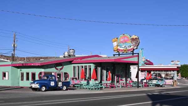
Mr. D'z Route 66 Diner at Kingman — a long single-storey building painted mint green with magenta trim, its rooftop sign carrying a burger, fries and a turquoise cartoon car above ROUTE 66 DINER lettering. A blue 1950s pickup with Route 66 shields on its door is parked at the kerb beside a pink novelty microcar, turquoise and magenta picnic tables and furled red umbrellas stand along the frontage, and a gift shop with its own Route 66 signs adjoins to the right. A dark basalt bluff closes the view at the left and the wide asphalt of the highway crosses the foreground. The railroad the town grew around is not in the frame.

Kingman

Kingman

The working hub of Route 66 in Arizona — a railroad town named for a surveyor, Andy Devine's hometown, and the last real stop before the road's two wildest endings.

View details →
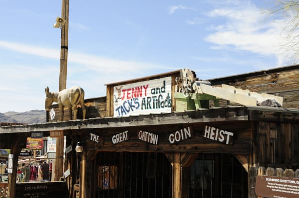
Storefronts on the main street of Oatman shot from below the eaves — a model burro standing on the porch roof at the left beside a Route 66 shield, a hand-lettered board reading JENNY and JACK'S ARTifacts behind it, and a piece of old ore-processing machinery with a green frame and a chute set along the roofline. A heavy timber beam across the front is painted THE GREAT OATMAN COIN HEIST, and the shopfronts beneath carry hand-painted signs for ice-cold drinks, burro food, leather goods and local artists. An interpretive panel headed GOLD MINING GHOST TOWN stands at the right. The live burros that roam the street, the Black Mountains and the Sitgreaves Pass switchbacks are all out of frame.

Oatman

Oatman

A gold camp in the Black Mountains that outlived its mines, now run by wild burros — reached by the wildest switchbacks left on Route 66, and named for a history worth telling straight.

View details →
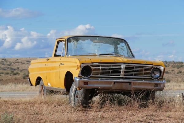
A derelict yellow Ford with a low open cargo bed standing in dry roadside grass near Peach Springs, filling the frame in three-quarter view. Its windscreen is crazed from edge to edge, one headlight is missing from its bezel, the panels and wheel arches are rusting through, and the near wheel is a bare rim with a rotted tyre still on it; FORD is lettered in chrome across the front edge above the grille. A strip of pavement runs behind it and open scrub reaches away to low ground under a blue sky with cumulus. Peach Springs itself is not in the frame: no part of the town, none of the Hualapai tribal government buildings, and no view to the canyon rim.

Peach Springs

Peach Springs

The capital of the Hualapai Nation — the People of the Tall Pines — on Route 66 at the rim of the Grand Canyon, gateway to Grand Canyon West and the only road to the Colorado's floor.

View details →

Roadside Stops

The roofline of the Hackberry General Store shot from below — a red flying-horse cut-out standing on the rusted corrugated eaves at the left, and beside it a shield-shaped board lettered HACKBERRY GENERAL STORE over POP · ICE · SNACKS · SOUVENIRS, with a black-and-white ROUTE 66 shield above it and a smaller brown board reading YOU ARE HERE! A round Coca-Cola disc and a diamond DRINK Coca-Cola sign hang on the corrugated wall beneath, a HISTORIC US 66 shield at the right, and a cottonwood stands behind. The yard of derelict cars and dead pumps the store is known for is out of frame.

Hackberry General Store

Kingman

Looks like a junkyard, is a shrine — the 1934 store an artist brought back from the dead, and the Route 66 stop that inspired Fillmore in Cars.

View details →
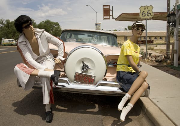
Two shop mannequins posed on the rear bumper of a pink-and-cream 1950s Ford parked at the kerb in Seligman — one dressed as Elvis in a white fringed jumpsuit, dark wig and sunglasses, leaning back against the continental spare-wheel cover, the other in a yellow t-shirt, denim skirt and white visor sitting on the fender with her legs crossed. A CLASSIC CRUISERS decal is on the rear window and an Arizona historic-vehicle plate on the spare cover. Behind them a tall U.S. 66 shield stands on a post beside an awning lettered CHICAGO and SANTA MONICA, with a ROUTE 66 MOTEL sign and a low stone building with arched windows beyond. Angel Delgadillo's barbershop is not in the frame.

Seligman

Seligman

The town that refused to die when the interstate went around it — a barber's crusade made this the Birthplace of Historic Route 66, and the reason the Mother Road still runs.

View details →

Scenic Drives through Route 66 & the Colorado River

Scenic Byway

Historic Route 66

Arizona's stretch of the Mother Road — the longest preserved run of Route 66 in the country, from the ponderosa high country down through Seligman and Kingman to the Oatman switchbacks and the Colorado River.

380 mi · 8 hrs
Scenic Byway

Route 66: The Topock Crossing

Ninety-six miles of the Mother Road's hardest crossing — Kingman over Sitgreaves Pass to Oatman, then down to the Colorado River at Topock, where three bridges, a sacred Mojave geoglyph and a chromium plume all sit on the same half mile of ground.

96 mi · 3 hrs
Scenic Byway

US-93: The Hoover Dam Crossing

The desert run from Kingman to Las Vegas — over the one place where Arizona and Nevada physically meet: Hoover Dam, wedged into Black Canyon, and the reservoir and neon it made possible.

109 mi · 2.5 hrs

Stories from Route 66 & the Colorado River

Culture

The Older Country Under the Mother Road

Route 66 turns a hundred in 2026 — and its Arizona miles run the length of a far older country than the one the postcards sell.

5 min read

Route 66 & the Colorado River rewards the unhurried. Pick a base, fan out, and let the country between the headline stops surprise you.

← Explore more of Open Road Guide