Home / North Carolina / Boone & the High Country / Grandfather Mountain
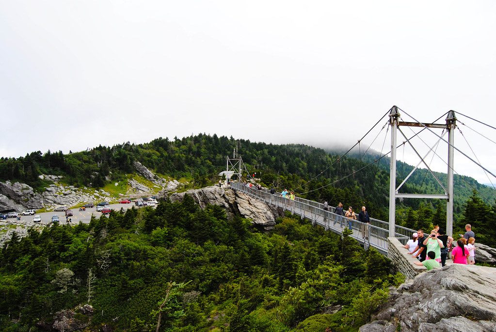
Visitors cross a cable suspension footbridge between two rocky peaks above spruce forest, with a parking lot and cloud-capped ridge behind.Elizabeth Albert / CC BY 2.0 via Flickr
🌲Natural

Grandfather Mountain

Part ofBoone & the High Country

The Cherokee Tanawha, highest point on the Blue Ridge escarpment, with Hugh Morton's 1952 swinging bridge and a state park backcountry since 2009.

⏱
Duration
Half a day for the attraction; a full day for the backcountry trails.
🎟
Admission
Admission is charged at the Grandfather Mountain Stewardship Foundation gate on US 221; the state park's backcountry trails have no day-use fee (2026).
📅
Best Season
Late spring through October; open every day except Thanksgiving and Christmas, weather permitting, and wind or ice can close the upper mountain (2026).

The Story

The Cherokee name for this mountain was Tanawha, meaning a fabulous hawk or eagle, and settlers later called it Grandfather for the old man's face they saw in its cliffs. Calloway Peak, the highest of its summits at 5,946 feet, crowns the eastern escarpment of the Blue Ridge and the Eastern Continental Divide. The mountain rises so abruptly from its neighbors that the French botanist Andre Michaux, climbing it in August 1794, believed he had reached the highest point in North America.

Most of the tracts on the mountain were bought in the 1880s from a grandson of Gen. William Lenoir for the Linville resort company that Donald MacRae's family came to control. Hugh Morton, grandson of Hugh MacRae, became sole owner in 1952, widened the road, carried it to the summit and built the Mile High Swinging Bridge that year. Mildred, a black bear bought in 1968 to be set free, would not return to the wild, and her enclosure grew into the animal habitats.

After Morton died in 2006, his family sold about 2,600 acres of backcountry to North Carolina, which opened Grandfather Mountain State Park in 2009, and gave the attraction to a nonprofit stewardship foundation. The ticketed gate on US 221 leads to the bridge, habitats and nature museum; the state park trails are free and steep. On the eastern flank the Blue Ridge Parkway crosses the Linn Cove Viaduct, 1,243 feet of concrete segments finished in 1983, part of the last stretch of a road begun in 1935 and opened in 1987.

Visitor Info

⏱
Time Needed
Half a day for the attraction; a full day for the backcountry trails.
🎟
Admission
Admission is charged at the Grandfather Mountain Stewardship Foundation gate on US 221; the state park's backcountry trails have no day-use fee (2026).
📅
Best Season
Late spring through October; open every day except Thanksgiving and Christmas, weather permitting, and wind or ice can close the upper mountain (2026).
🛣️
Highway
US 221 (Blowing Rock Highway)

On the Map

Nearby

The closest stops worth working into your route

historical9.6 mi away
Moses H. Cone Memorial Park
The Denim King's 1901 summer manor above Blowing Rock, its orchards worked by local families and its house by African American servants, given to the Parkway in 1949.
natural10 mi away
Linville Falls and Linville Gorge
The river the Cherokee called the river of many cliffs drops over twin falls into an old-growth gorge, one of the first wilderness areas in the nation.
cultural13 mi away
Doc Watson Statue
A bronze of Doc Watson on a bench at King and Depot streets, where the blind guitarist from Deep Gap first played for tips in the 1940s.
natural15 mi away
Roan Mountain and Carvers Gap
The saddle on the Tennessee-North Carolina line where the Appalachian Trail crosses the Roan Highlands' grass balds, with Catawba rhododendron gardens, rare spruce-fir forest and the site of the Cloudland Hotel.
cultural18 mi away
Penland School of Craft
Lucy Morgan's 1923 weaving cooperative for mountain women grew into a national craft school, with a gallery and a campus visitors can walk.
historical20 mi away
Fort Defiance
William Lenoir's 1792 plantation house in Happy Valley, named for a frontier stockade of the 1776 Cherokee war, with tours that include the people he enslaved.

Historical markers nearby

Roadside plaques and monuments within a short detour

Marker0 mi away
Asa Gray
Linville
Marker0.1 mi away
Andre Michaux
Linville
Marker5.6 mi away
Shepherd M. Dugger
Banner Elk
Marker5.6 mi away
Lees-McRae College
Banner Elk
Marker6.3 mi away
Crossnore School
Crossnore
Marker8 mi away
Cranberry Mines
Cranberry