Home / Kentucky / Cumberland Gap & the Coalfields / Breaks Interstate Park
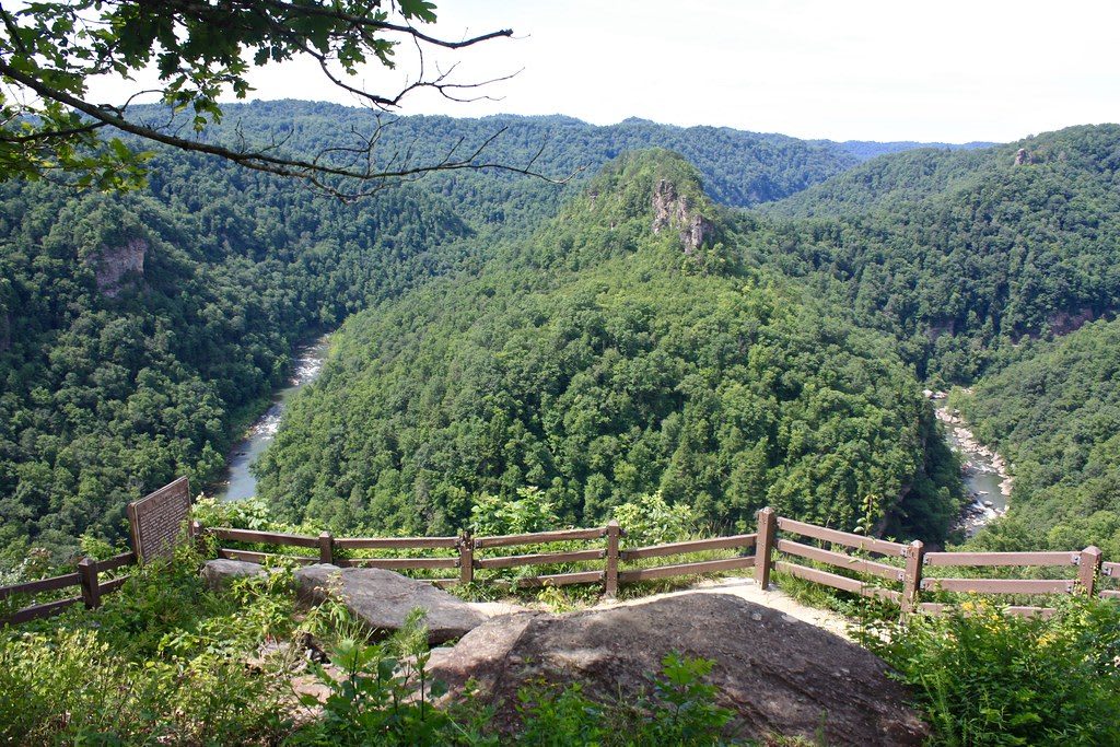
A wooden-railed overlook above a horseshoe bend of the Russell Fork, which loops around a forested ridge topped by rock towers.Virginia State Parks / CC BY 2.0 via Flickr
🌲Natural

Breaks Interstate Park

Part ofCumberland Gap & the Coalfields

The Russell Fork's five-mile gorge through Pine Mountain on the Kentucky-Virginia line, run by both states since 1954, reached from Elkhorn City on KY-80.

⏱
Duration
Half a day to a full day.
🎟
Admission
See the park commission for current fees.
📅
Best Season
Spring through fall; October for the whitewater releases and color.

The Story

The Russell Fork of the Big Sandy cuts through the northeastern end of Pine Mountain here, and the gorge it made is about five miles long and in places more than 1,000 feet deep. The land was hunting ground for Shawnee and Cherokee people. Tradition says Daniel Boone came through in 1767 looking for an easier way west across the mountain and gave the place its name, the Breaks.

A newspaper story in 1930 predicted a national park here; the Second World War interrupted that plan, and a campaign led by the Pikeville businessman Kelley Day won protection of another kind. Kentucky and Virginia formed the Breaks Interstate Park Commission in 1954, four members from each state, and the park is still one of only two in the country run under an interstate compact. The CSX line, once the Clinchfield, runs through the canyon below the overlooks, which include the Towers, where a river bend circles a rock island, and Stateline, a sunset view to the west.

The Russell Fork drops nearly 280 feet through the gorge, and its rapids reach Class V. On the first four weekends of October releases from John W. Flannagan Dam upstream bring expert paddlers from across the East. Elk, restored to Kentucky and then to Virginia from Kentucky stock, range nearby. From Elkhorn City, KY-80 crosses into Virginia within a few miles; the visitor center and lodge stand just over the line.

Visitor Info

⏱
Time Needed
Half a day to a full day.
🎟
Admission
See the park commission for current fees.
📅
Best Season
Spring through fall; October for the whitewater releases and color.
🛣️
Highway
KY-80

On the Map

Nearby

The closest stops worth working into your route

historical16 mi away
Dils Cemetery
Pikeville's 1871 hillside cemetery, an early integrated burial ground, where Randolph and Sarah McCoy lie after the feud drove them off Blackberry Creek.
historical35 mi away
Hindman Settlement School
The 1902 school at the forks of Troublesome Creek, the first rural settlement school in the country, home of the Appalachian Writers Workshop and James Still's grave.
natural39 mi away
Lilley Cornett Woods
Two hundred fifty-two acres of old-growth Appalachian forest in Letcher County, kept uncut by one owner and walked today with Eastern Kentucky University guides.
cultural39 mi away
Loretta Lynn's Homeplace, Butcher Hollow
The Webb family cabin in Butcher Hollow above Van Lear, the Consolidation Coal town in Coal Miner's Daughter, with tours from the 1918 Mine No. 5 store.
industrial39 mi away
Portal 31 Underground Mine Tour
A rail-car ride into one of the original entries of U.S. Steel's Lynch mines, in the 1917 coal town that drew miners from 38 nations.
industrial41 mi away
Kentucky Coal Museum
Four floors of coal-camp life in International Harvester's 1923 commissary at Benham, the company town Wisconsin Steel built on Looney Creek.

Historical markers nearby

Roadside plaques and monuments within a short detour

Marker16 mi away
Pikeville Collegiate Institute
Pikeville
Marker16 mi away
John Paul Riddle, 1901-1989
Pikeville
Marker16 mi away
Effie Waller Smith
Pikeville
Marker18 mi away
Dunham High School
Jenkins
Marker18 mi away
Lt. Darwin K. Kyle
Jenkins
Marker19 mi away
Pound Gap
Jenkins